


GM-22 — Geology of Brazos Peak quadrangle
We are a research and service division of:
By William R. Muehlberger, 1968, lat 36°45' to 37°00', long 106°15' to 106°30', 7 pp., 3 sheets and 7 page booklet, scale 1:48,000.
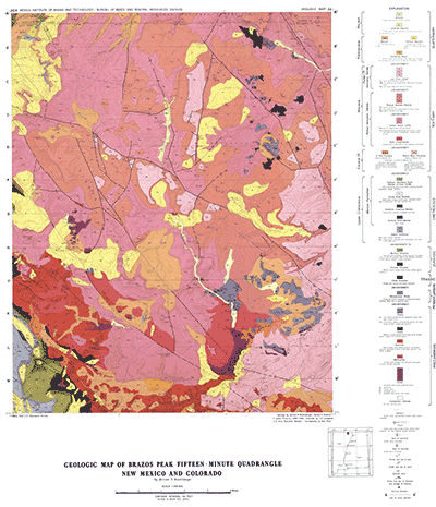
The Brazos Peak quadrangle lies adjacent to the Chama quadrangle along the New Mexico-Colorado line in the north-central part of the state. In addition to the geologic maps, a short text describes stratigraphic sequences of the Precambrian and Cenozoic rocks of the area and briefly reviews geologic structure, which here has a history intimately related to that of the Chama quadrangle.
$6.50
Buy
Now
Also available as a free download.
Download
| File Name | Size | Last Modified |
|---|---|---|
| GM-22_booklet.pdf | 8.79 MB | 02/05/2021 02:54:25 PM |
| GM-22_complete.zip | 23.63 MB | 02/05/2021 02:57:27 PM |
| GM-22_map.pdf | 14.67 MB | 02/05/2021 02:54:31 PM |
| GM-22_structure-tectonic.pdf | 1.11 MB | 02/05/2021 02:55:26 PM |
| GM-22_xsects.pdf | 1.44 MB | 02/05/2021 02:56:30 PM |
| TIFF: | ||
| GM-22_map-pal.tif | 34.99 MB | 09/18/2018 09:33:58 AM |
| GM-22_map.tif | 203.20 MB | 09/18/2018 09:32:03 AM |
| GM-22_structure-tectonic.tif | 1.52 MB | 09/18/2018 09:36:30 AM |
| GM-22_xsects.tif | 1.98 MB | 09/18/2018 09:38:18 AM |