


GM-36—Geology of east half Corralitos Ranch Quadrangle, New Mexico
We are a research and service division of:
By R. E. Clemons, 1976, lat 32°22'30" to 32°50', long 107°00' to 107°07'30", text, 2 sheets, scale 1:24,000.
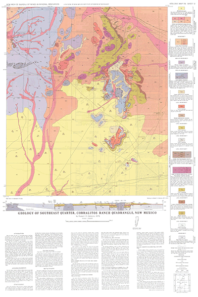
These two sheets are part of a continuing program of geologic investigations of the Rio Grande trough and adjacent uplifts between Hatch and Las Cruces. Field data were plotted on aerial photographs with a scale of 2½ inches to the mile, then transferred to the topographic bases enlarged to 1:24,000 scale.
The map area is located 14 miles northwest of Las Cruces. Access to the area is provided by a paved road to the Corralitos Ranch microwave tower from I-10 west of Las Cruces. A good gravel road continues from the microwave tower across the area to the New Mexico State University Observatory at Blue Mesa in the Sierra de las Uvas. Access to the northeastern part of the area is provided by the travertine quarries road from US-85, 1 mile north of Radium Springs. A complex of ranch roads and jeep trails penetrates most of the map area. The entire area is sparsely vegetated grazing land, with the only permanent habitation being the Corralitos Ranch headquarters near the southeastern edge of the area. A completed discussion of the climate and vegetation is included in Seager and Hawley (1973) and Seager, Clemons, and Hawley (1975). The Butterfield Trail crossed the map area through the southern part of T. 22 S.
$7.00
Buy
Now
Also available as a free download.
Download
| File Name | Size | Last Modified |
|---|---|---|
| GM-36_RoughAndReadyHills-SleepingLadyHills.pdf | 24.39 MB | 02/05/2021 03:07:58 PM |
| GISdata: | ||
| GeMSVariationRedaMe.txt | 1 KB | 07/31/2019 12:31:59 PM |
| RoughandReadyHills_GM-36.mpk | 3.49 MB | 07/08/2019 02:28:09 PM |
| SleepingLadyHills_GM-36.mpk | 3.08 MB | 07/08/2019 02:46:18 PM |