


GM-57—Geology of east half of Las Cruces and northeast El Paso 1º x 2º sheets, New Mexico
We are a research and service division of:
By W. R. Seager, J. W. Hawley, F. E. Kottlowski, and S. A. Kelley, 1987, lat 32°00' to 33°00', long 106°00' to 107°00', 1 table, 3 sheets (geologic map, seven cross sections and corresponding gravity profiles on two sheets, and a translucent Bouguer anomaly map overlay on two sheets), scale 1:125,000.
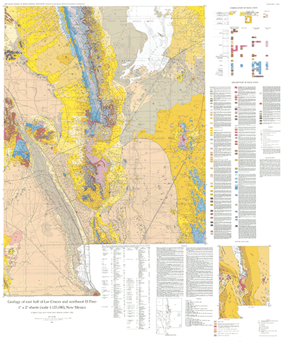
The 42" x 50" geologic map sheet includes approximately 80 unit descriptions, a small tectonic map of the area, and a table describing 56 wells within the map boundary. GM-57 is the second in a series of three maps that covers the entire Las Cruces 1º x 2º quadrangle and the northern portion of the El Paso 1º x 2º quadrangle. It is preceded by GM-53, Geology of northwest part of Las Cruces 1º x 2º sheet, New Mexico, published in 1982. The third and final map in the series, GM-60, Geology of southwest quarter of Las Cruces and northwest El Paso 1º x 2º sheets, New Mexico was published in 1995. More detail is covered in GM 63 and Bulletin 113.
$21.00
Buy
Now
Also available as a free download.
Download
| File Name | Size | Last Modified |
|---|---|---|
| GM-57_map.pdf | 26.63 MB | 02/05/2021 03:47:51 PM |
| GM-57_Sheet-2a.pdf | 4.70 MB | 02/05/2021 03:48:05 PM |
| GM-57_Sheet-2b.pdf | 5.04 MB | 02/05/2021 03:50:09 PM |
| ReadMe.txt | 0 KB | 09/10/2018 02:07:40 PM |
| GIS Data: | ||
| GM57.mpk | 7.88 MB | 12/06/2018 01:41:44 PM |
| TIFF: | ||
| GM-57_map-pal.tif | 75.15 MB | 09/10/2018 01:53:59 PM |
| GM-57_map.tif | 351.30 MB | 09/10/2018 12:20:54 PM |