


GM-59—Geology of South Peak Quadrangle, Luna County, New Mexico
We are a research and service division of:
By R. E. Clemons, 1985, lat 32°00' to 32°07'30", long 107°37'30" to 107°45', 3 sheets with text, scale 1:24,000.
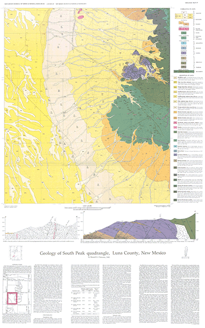
South Peak quadrangle is one of four conterminous 7½-minute quadrangles mapped in the Florida Mountains in east-central Luna County. GM-59 is the fourth phase of a comprehensive geologic and mineral-resource investigation of the Florida Mountains. It is preceded in publication by GM-52, Geology of the Florida Gap quadrangle, GM-56, Geology of the Capitol Dome quadrangle, and GM-58, Geology of the Gym Peak quadrangle. A comprehensive layout is found in Memoir 43.
South Peak quadrangle is in east-central Luna County, approximately 12 mi southeast of Deming. Good access to the base of the Florida Mountains is provided by gravel roads and jeep trails leading eastward from NM-11, which crosses the southeast part of the quadrangle about midway between Deming and Columbus. The Nathan Crawford Ranch headquarters and several permanent dwellings are in the north-central to northwest parts of the quadrangle.
$6.75
Buy
Now
Also available as a free download.
Download
| File Name | Size | Last Modified |
|---|---|---|
| GM-59.pdf | 13.15 MB | 02/05/2021 03:51:03 PM |
| GeoPDF: | ||
| SouthPeakGeoPDF.pdf | 2.80 MB | 08/09/2021 08:46:26 AM |
| GISdata: | ||
| SouthPeak.mpk | 23.09 MB | 07/08/2021 02:36:56 PM |