


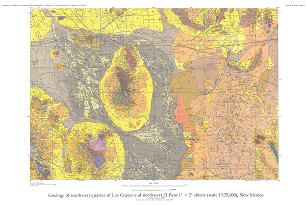
GM-60—Geology of southwest quarter of Las Cruces and northwest El Paso 1º x 2º sheets, New Mexico
We are a research and service division of:
By W. R. Seager, 1995, lat 31°47'02" (U.S. - Mexico border) to 32°22'30", long 107° to 108°00', 5 sheets (including geologic map and six cross-section interpretations based on gravity data and outcropping geologic formations), scale 1:125,000.
GM-60 is the third and final map in a series that covers the entire Las Cruces 1º x 2º quadrangle and the northern part of the El Paso 1º x 2º quadrangle. GM-60 is preceded by GM-53, Geology of northwest part of Las Cruces 1º x 2º sheet, New Mexico, and GM-57, Geology of east half of Las Cruces and northeast El Paso 1º x 2º sheets, New Mexico.
Included in this area, which covers roughly 40 mi north-south and 60 mi east-west, are the towns of Deming and Columbus; the Potrillo, Florida, Tres Hermanas, and Cedar Mountains; the Mt. Riley-Mt. Cox volcanic domes; and the Mimbres and Deming Basins. Eighty map units are correlated graphically and described briefly. The rocks in the map area range from Precambrian granitic and syenitic plutonic and metamorphic rocks to Paleozoic limestone, dolomite, sandstone, siltstone, and shale to Tertiary volcanic, volcaniclastic, and epiclastic rocks and Quaternary basin fill associated with the huge Mogollon-Datil volcanic field and the southern Rio Grande rift.
More detailed mapping (1:24,000) of the southeast and southwest corners of the GM-60 map area has been published in Bulletin 113, Geology of East Potrillo Mountains and vicinity, Doña Ana County, New Mexico, and as GM-63, Geology of Hermanas quadrangle, Luna County, New Mexico. The East Potrillo Mountains offered an excellent opportunity to study Laramide deformation and middle Tertiary low-angle normal faulting. Detailed mapping of the Hermanas 7½-min quadrangle revealed complexly faulted and altered volcanic rocks that could not be represented on a 1:125,00-scale map.
$15.00
Buy
Now
Also available as a free download.
Download
| File Name | Size | Last Modified |
|---|---|---|
| GM-60_GeologicMap.pdf | 5.38 MB | 02/05/2021 03:56:02 PM |
| GM-60_Sheet2.pdf | 2.35 MB | 02/05/2021 03:58:21 PM |
| GM-60_Sheet3.pdf | 3.14 MB | 02/05/2021 03:57:42 PM |
| GM-60_Sheet4.pdf | 1.46 MB | 02/05/2021 03:59:04 PM |
| ReadMe.txt | 0 KB | 02/05/2021 03:55:48 PM |
| GISdata: | ||
| GeMSVariationRedaMe.txt | 1 KB | 07/31/2019 12:31:59 PM |
| GM_60.mpk | 6.41 MB | 07/09/2019 01:36:50 PM |
| TIFF: | ||
| GM-60_GeologicMap-pal.tif | 13.20 MB | 09/10/2018 11:21:04 AM |
| GM-60_GeologicMap.tif | 73.73 MB | 09/10/2018 11:18:30 AM |