


GM-62—Geology and coal resources of Fence Lake 1:50,000 quadrangle, New Mexico (sw quadrant of Fence Lake 1:100,000 sheet)
We are a research and service division of:
By F. Campbell, 1989, lat 34°30'00" to 45'00", long 108°30'00" to 109°00', 2 sheets, scale 1:50,000.
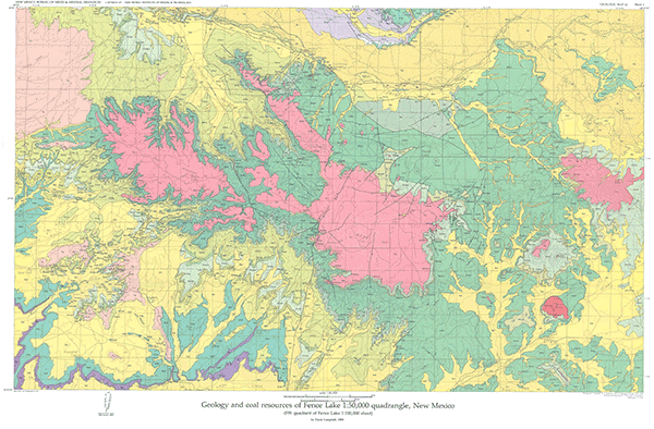
Detailed mapping of eight 7½-min quadrangles, geophysical logs from 38 drill holes, and chemical analyses of coals from the Moreno Hill Formation provided the primary data for this compilation of the geology and coal resources in the southwest quadrant of the Fence Lake 1:100,000 metric-scale map. GM-62 lies adjacent to and supplements previously published GM-61, Geology and coal resources of Atarque Lake 1:50,000 quadrangle, New Mexico, by extending geologic compilation to the eight 7½-min quadrangles immediately to the south, an area just north of Quemado that extends to within 3 mi of the Arizona border. It encompasses the northern part of the Salt Lake coal field and the type area of the Fence Lake Formation (late Tertiary). Rock exposures range from the Triassic Chinle Formation to the 1.41 Ma Jaralosa Draw lobe of the North Plains lava field. A discussion of the stratigraphy, detailed analyses of the coal resources, generalized geologic column, and 21 map-unit descriptions accompany the geologic map.
$7.00
Buy
Now
Also available as a free download.
Download
| File Name | Size | Last Modified |
|---|---|---|
| GM-62_complete.zip | 13.70 MB | 02/05/2021 04:01:23 PM |
| GM-62_discussion.pdf | 9.44 MB | 02/05/2021 04:01:11 PM |
| GM-62_map.pdf | 5.21 MB | 02/05/2021 04:01:17 PM |
| TIFF: | ||
| GM-62_map-pal.tif | 15.71 MB | 09/07/2018 04:39:02 PM |
| GM-62_map.tif | 88.48 MB | 09/07/2018 04:37:36 PM |