


GM-65—Geology and mineral resources of the Jones Ranch School Quadrangle, McKinley County, New Mexico
We are a research and service division of:
By O. J. Anderson, 1989, lat 35°15' to 35°22'30", long 108°52'30" to 109°00', 1 sheet with text, scale 1:24,000.
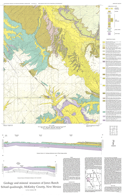
Jones Ranch School 7½-min quadrangle in southwestern McKinley County lies in the northwestern part of the Zuni Basin. NM-602 (old NM-32) south of Gallup and the Jones Ranch School Road provides access to the quadrangle. Jones Ranch School quadrangle is bisected diagonally northwest-southeast by the Piñon Springs anticline, which creates as much as 1,200 ft of structural relief and interrupts the rather uniform and gentle northeastward dips of the Paleozoic and Mesozoic rock sequence. Rock exposures range from the Triassic Chinle Formation to the Tertiary Bidahochi Formation. GM-65 includes a detailed discussion of the stratigraphy, a short discussion on mineral-resource potential, two cross sections, and 15 map-unit descriptions. This is a companion to GMs 64 and 66.
$6.00
Buy
Now
Also available as a free download.
Download
| File Name | Size | Last Modified |
|---|---|---|
| GM_65.pdf | 9.31 MB | 02/05/2021 04:01:51 PM |
| TIFF: | ||
| GM_65_map.tif | 9.28 MB | 09/07/2018 03:56:27 PM |