


GM-67—Geology of French Mesa quadrangle, Rio Arriba County, New Mexico
We are a research and service division of:
By D. L. Crouse, M. C. Hultgren, and L. A. Woodward, 1992, lat 36°15' to 36°22'30", long 106°45' to 106°52'30", 1 sheet with text, scale 1:24,000.
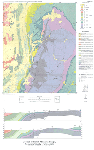
French Mesa 7½-min quadrangle is in Rio Arriba County, just north of Gallina and NM-96. The two major tectonic features in the quadrangle, the Gallina-Archuleta arch and the San Juan Basin, are separated by the north-south-trending Hogback monocline. Two major north-northeast-trending faults that also bisect the quadrangle are the Gallina and Cañada faults. The oldest rock unit exposed in the French Mesa quadrangle is the Lower Permian Cutler Formation. On French Mesa in the eastern part of the quadrangle, extensive areas of Chinle Formation unconformably overlie the Cutler. From the eastern margin of the San Juan Basin westward, large areas of Quaternary alluvium cover progressively younger rock units, from the Jurassic Todilto and Morrison Formations to the Eocene San Jose Formation. Nine wells drilled for hydrocarbons in the French Mesa quadrangle are plotted on the map; four produced oil, with initial production ranging from 55 to 360 barrels of oil per day. Exploration targets are fractured intervals within the Mancos Shale along the steep flexure of the eastern flank of the San Juan Basin. In addition to short discussions of stratigraphy, structure, and mineral resources, GM-67 includes two cross sections and 18 map-unit descriptions.
$6.00
Buy
Now
Also available as a free download.
Download
| File Name | Size | Last Modified |
|---|---|---|
| GM-67_complete.zip | 8.41 MB | 02/05/2021 04:02:30 PM |
| GM-67_discussion.pdf | 5.26 MB | 02/05/2021 04:02:14 PM |
| GM-67_map.pdf | 3.50 MB | 02/05/2021 04:02:20 PM |
| TIFF: | ||
| GM-67_map-pal.tif | 10.66 MB | 09/07/2018 01:52:03 PM |
| GM-67_map.tif | 59.37 MB | 09/07/2018 01:49:43 PM |