


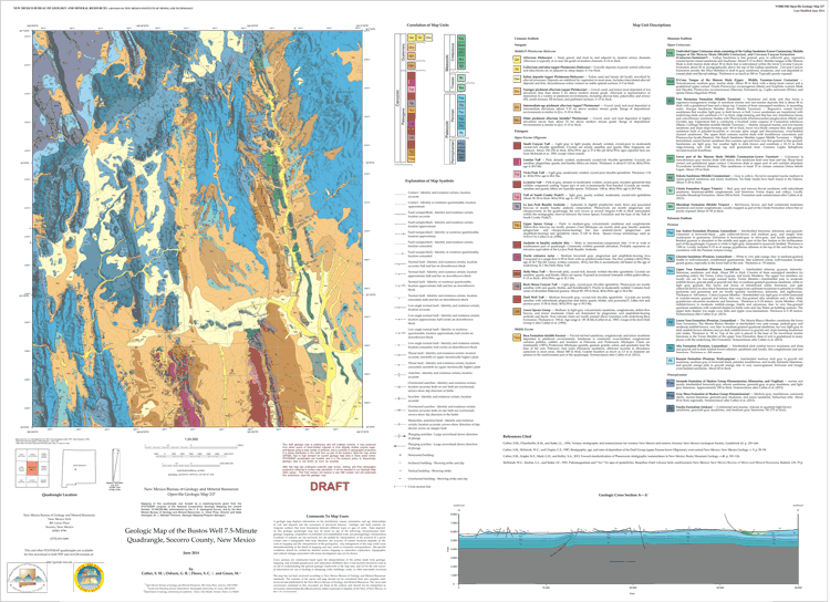
Open-file Geologic Map - 237
Geologic map of the Bustos Well 7.5-Minute Quadrangle, Socorro County, New Mexico
Steven M. Cather, G. Robert Osburn, S. C. Flores, and Mark Green
2014
scale 1 : 24,000
https://doi.org/10.58799/OF-GM-237
Downloads
| File Name | Size | Last Modified |
|---|---|---|
| OFGM-237_BustosWell.pdf | 14.40 MB | 02/19/2021 09:17:33 AM |
| OFGM-237_BustosWellReport.pdf | 223 KB | 02/19/2021 09:17:41 AM |
| Thumbnail: | ||
| MapImage.gif | 127 KB | 01/14/2015 04:58:32 PM |
Notes:
Geologic mapping of this and other 7½-minute quadrangles in New Mexico is being cooperatively funded by the USGS through the STATEMAP program and with matching funds from the Bureau. For a list of quadrangles in this series, please visit the Open-file Geologic Map (OF-GM) page or try our search page for geologic maps of any series.
These maps are open-filed as they become available. Initially, maps are posted as PDF files of scans of the hand-drawn linework, and later as full color maps and GIS products. These files can be downloaded for free or may be purchased on CD-ROM.
These maps are subject to frequent revisions and may be unavailable when being revised. Map Reference dates show the time of initial compilation; Map Revision dates, when given, indicate the most current version of the map; Last Modified dates for files may not accurately reflect the time the map was last revised.
Please direct comments or requests regarding these maps to either the map authors or the Geologic Mapping Program Manager.