


Open-file Geologic Map - 265
Geologic Map of the McCartys 7.5-Minute Quadrangle, Cibola County, New Mexico
Colin T. Cikoski, Paul G. Drakos, and James Riesterer
2017
(last revised: 21-August-2017)
scale 1 : 24,000
https://doi.org/10.58799/OF-GM-265
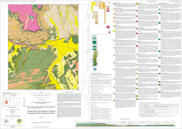
The McCartys quadrangle lies a few kilometers (km) east-southeast of the town of Grants along I40 in northwestern New Mexico. Over half the quadrangle lies on Pueblo of Acoma land, while the remainder is a mix of private ranch land, BLM, and minor state of New Mexico land. The Rio San Jose river valley roughly bisects the quadrangle along an east-west transect. The northeast quarter of the quadrangle lies mainly on the broad, low-relief southern piedmont of Mount Taylor, and is traversed south-southeastward by Rinconada Creek. The northwest quarter of the quadrangle is dominated by Horace Mesa, a broad “prong” of the Mount Taylor highland capped by Plio-Pleistocene basalt flows. The south half of the quadrangle consists of low sandstone-capped mesas separated by broad alluvial valleys. Elevations ranges from about 1,854 meters (m) above mean sea level (amsl) where the Rio San Jose exits the quadrangle to a high of about 2,336 m amsl on Horace Mesa.
Geologically, the quadrangle lies in the Acoma Sag section of the Colorado Plateau along the eastern limb of the McCartys syncline (Woodward, 1982), along or just south of the Jemez lineament and to the south of the Mount Taylor volcanic field and east of the Zuni-Bandera volcanic field. The majority of the quadrangle is underlain by clastic Mesozoic strata capped by a variable thickness of Pliocene to Holocene basalts and Quaternary alluvial cover. Structural relief is generally low.
Downloads
| File Name | Size | Last Modified |
|---|---|---|
| OFGM-265_McCartys.pdf | 11.96 MB | 02/19/2021 02:23:10 PM |
| OFGM-265_McCartysReport.pdf | 2.41 MB | 02/19/2021 02:23:20 PM |
| GISdata: | ||
| OFGM-265_McCartys.mpk | 18.03 MB | 08/21/2017 10:46:25 AM |
Notes:
Geologic mapping of this and other 7½-minute quadrangles in New Mexico is being cooperatively funded by the USGS through the STATEMAP program and with matching funds from the Bureau. For a list of quadrangles in this series, please visit the Open-file Geologic Map (OF-GM) page or try our search page for geologic maps of any series.
These maps are open-filed as they become available. Initially, maps are posted as PDF files of scans of the hand-drawn linework, and later as full color maps and GIS products. These files can be downloaded for free or may be purchased on CD-ROM.
These maps are subject to frequent revisions and may be unavailable when being revised. Map Reference dates show the time of initial compilation; Map Revision dates, when given, indicate the most current version of the map; Last Modified dates for files may not accurately reflect the time the map was last revised.
Please direct comments or requests regarding these maps to either the map authors or the Geologic Mapping Program Manager.