


Open-file Geologic Map - 270
Geologic Map of the Romero Canyon 7.5-Minute Quadrangle, Sierra and Socorro Counties, New Mexico
Colin T. Cikoski
2018
(last revised: 5-July-2018)
scale 1 : 24,000
https://doi.org/10.58799/OF-GM-270
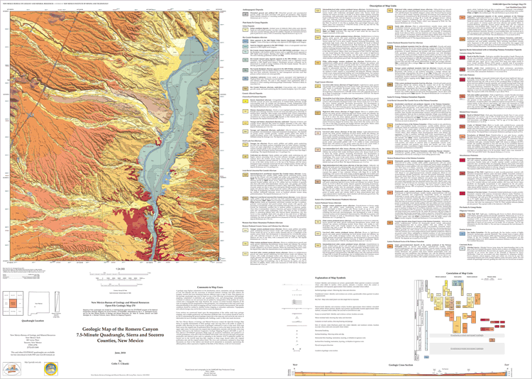
The Romero Canyon 7.5-minute quadrangle straddles the Rio Grande roughly 26 km north of the city of Truth or Consequences. The quadrangle extends from the base of the Fra Cristobal Mountains on the east to about 9 km up the piedmont of the San Mateo Mountainsto the west, and from “The Narrows” of the Rio Grande on the south to about the latitude of the northern end of the Fra Cristobal Mountains on the north. It covers the outlets of Nogal Canyon and San Jose Arroyo as each enters the inner Rio Grande valley from the west. During the time that field work was performed (2016-18), Elephant Butte Lake lay entirely south of the quadrangle, although during high lake levels the lake would extend into the quadrangle and flood the on-quadrangle Rio Grande floodplain. Land surface elevations range from about 1,653 meters (m) above mean sea level (amsl) on a ridge top extending into the quadrangle from the San Mateo Mountains to about 1,338 m amsl where the Rio Grande exits the quadrangle.
Geologically, the quadrangle lies mainly in the Engle basin, an east-tilted rift basin down-dropped along the Hot Springs and Walnut Canyon faults, which lie at the base of the Cutter Sag and Fra Cristobal Mountains, respectively. The basin is of at least Plio-Pleistocene age, during which time it accumulated sediments delivered to the basin by an ancestral Rio Grande as well as piedmont deposits derived from both the Fra Cristobal Mountains to the east (eastern piedmont alluvium) and the San Mateo Mountains, Sierra Cuchillo, and Mud Springs Mountains to the west (western piedmont alluvium). From ~5 to ~0.8 Ma (Mack et al., 2006), the Rio Grande and its tributaries overall aggraded and alluvial sediment accumulated. Since ~0.8 Ma, however, these streams have overall incised, with periods of stability and/or aggradation resulting in flights of terrace deposits along both the Rio Grande and its tributaries. The highest constructional surface associated with the aggradational phase is here referred to as the Cuchillo surface (Lozinsky and Hawley, 1986; McCraw and Love, 2012), and the sediment below this surface that accumulated coeval with an ancestral Rio Grande is referred to the Palomas Formation of the Santa Fe Group (Lozinsky and Hawley, 1986). The aggradational phase was punctuated by a series of basaltic volcanic eruptions associated with the Caballo (also called Engle and Cutter Sag) volcanic field, several vents of which are exposed on the quadrangle.
Pre-Plio-Pleistocene rocks are exposed in a few hills in the northwestern quarter of the quadrangle. These are exclusively underlain by Vicks Peak Tuff, a regional Oligocene ignimbrite that erupted from the Nogal Canyon caldera, located in what is now the San Mateo Mountains. This tuff is generally considered a part of the sequence of volcanic units associated with the Mogollon-Datil volcanic field, the majority of which lies to the west of the quadrangle. That no thick volcanic rocks appear to be found east of the quadrangle suggests that the quadrangle lies at the eastern edge of that volcanic field.
Downloads
| File Name | Size | Last Modified |
|---|---|---|
| OFGM-270_RomeroCanyon.pdf | 15.65 MB | 02/19/2021 02:31:28 PM |
| OFGM-270_RomeroCanyonReport.pdf | 1.86 MB | 02/19/2021 02:31:38 PM |
| GISdata: | ||
| OFGM-270_RomeroCanyon.mpk | 21.14 MB | 07/05/2018 09:23:14 AM |
Notes:
Geologic mapping of this and other 7½-minute quadrangles in New Mexico is being cooperatively funded by the USGS through the STATEMAP program and with matching funds from the Bureau. For a list of quadrangles in this series, please visit the Open-file Geologic Map (OF-GM) page or try our search page for geologic maps of any series.
These maps are open-filed as they become available. Initially, maps are posted as PDF files of scans of the hand-drawn linework, and later as full color maps and GIS products. These files can be downloaded for free or may be purchased on CD-ROM.
These maps are subject to frequent revisions and may be unavailable when being revised. Map Reference dates show the time of initial compilation; Map Revision dates, when given, indicate the most current version of the map; Last Modified dates for files may not accurately reflect the time the map was last revised.
Please direct comments or requests regarding these maps to either the map authors or the Geologic Mapping Program Manager.