Skip Navigation Links

Your browser may be very out of date -- consider upgrading!


NMBGMR Geologic Mapping Program
Open-File Geologic Map Series (OF-GM)

Geologic mapping of 7.5-minute quadrangles is being cooperatively funded by the USGS through the STATEMAP program and with matching funds from the NMBGMR. Mapping for these projects, at a scale of 1 : 24,000 or larger, is completed in one or two years depending on complexity. Because priorities for projects are largely driven by societal needs, most of these maps have been within the Rio Grande watershed where detailed mapping most benefits our population centers. However, our program is now branching out to other important regions and watersheds of our state including the Carlsbad, Ruidoso, Alamogordo, Roswell, Silver City, and Farmington areas.
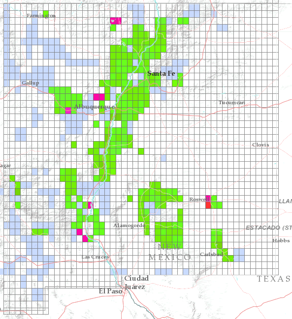
These maps are open-filed as they become available, initially as PDF files of scans of the hand-drawn linework and later as full color maps and GIS products. Following cartographic production and editorial review, these maps may be published within our GM-series or be included in larger maps of regions of particular interest.


Find an OF-GM product: (Also see listings by Title, Author, and Map Number.)


Notes:

These maps are subject to frequent revisions and may be unavailable when being revised. Map reference dates show the time of initial compilation — map revision dates, when given, indicate the most current version of the map.

Please direct comments or requests regarding these maps to either the map authors or the Geologic Mapping Program Manager.


Recent OF-GM Products

Some publications, including those that are out-of-print, are only available on CD-ROM CD icon.

Stock# Title Price
OF-GM-135 Preliminary geologic map of the Cloudcroft quadrangle, Otero County, New Mexico, Hallett, B, 2007, Scale 1:24,000, [CD-ROM on demand], (PDF file). $10.00
CD-ROM format
OF-GM-140 Preliminary geologic map of the La Joya NW quadrangle, Socorro County, New Mexico, Connell, S. D., McCraw, D. J., 2007, Scale 1:24,000, [CD-ROM on demand], (PDF file). $10.00
CD-ROM format
OF-GM-141 Preliminary geologic map of the La Madera quadrangle, Rio Arriba County, New Mexico, Koning, D. J., Karlstrom, K. E., Salem, A., Lombardi, C., 2007, Scale 1:24,000, [CD-ROM on demand], (PDF file). $10.00
CD-ROM format
OF-GM-142 Preliminary geologic map of the Ladron Peak quadrangle, Socorro County, New Mexico., Read, A. S., Cather, S. M., Chamberlin, R. M., Connell, S.D., Karlstrom, K.E., 2007, Scale 1:24,000, [CD-ROM on demand], (PDF file). $10.00
CD-ROM format
OF-GM-143 Preliminary geologic map of the Stanley quadrangle, Santa Fe County, New Mexico., Allen, B. D., 2007, Scale 1:24,000, [CD-ROM on demand], (PDF file). $10.00
CD-ROM format
OF-GM-144 Preliminary geologic map of the Taos Junction quadrangle, Taos County, New Mexico, Koning, D. J.: Aby, S.: Kelson, K., 2007, Scale 1:24,000, [CD-ROM on demand], (PDF file). $10.00
CD-ROM format
OF-GM-145 Preliminary geologic map of the Tres Ritos quadrangle, Taos County, New Mexico, Aby, S.; Hallet, B, 2007, Scale 1:24,000, [CD-ROM on demand], (PDF file). $10.00
CD-ROM format
OF-GM-146 Preliminary geologic map of the CaƱon Agua Buena quadrangle, Socorro County, New Mexico, Cather, S. M., 2007, Scale 1:24,000, [CD-ROM on demand], (PDF file). $10.00
CD-ROM format
OF-GM-147 Preliminary geologic map of the Bay Buck Peaks quadrangle, Socorro County, New Mexico, Osburn, G. R.; Ferguson, C. A., 2007, Scale 1:24,000, [CD-ROM on demand]. $10.00
CD-ROM format
OF-GM-148 Preliminary geologic map of the Welty Hill quadrangle, Socorro, County, New Mexico, Ferguson, C. A.; Osburn, G. R., 2007, Scale 1:24,000, [CD-ROM on demand], (PDF file). $10.00
CD-ROM format
OF-GM-149 Preliminary geologic map of the White Rock 7.5-minute quadrangle, Sandoval and Los Alamos Counties, New Mexico, Dethier, D. P.; Koning, D. J., 2007, Scale 1:24,000, [CD-ROM on demand], (PDF file). $10.00
CD-ROM format
OF-GM-150 Preliminary geologic map of the Canjilon SE quadrangle, Rio Arriba County, New Mexico, Kempter, K. A.; Zeigler, K.; Koning, D. J.; Lucas, S., 2007, Scale 1:24,000, [CD-ROM on demand], (PDF file). $10.00
CD-ROM format
OF-GM-151 Preliminary geologic map of the Bitter Lake quadrangle, Chaves County, New Mexico, McCraw, D. J.; Rawling, G.; Land, L. A., 2007, Scale 1:24,000, [CD-ROM on demand], (PDF file). $10.00
CD-ROM format
OF-GM-152 Preliminary geologic map of the Fort Bayard quadrangle, Grant County, New Mexico, Skotnicki, S. J.; Ferguson, C. A., 2007, Scale 1:24,000, [CD-ROM on demand], (PDF file). $10.00
CD-ROM format
OF-GM-153 Preliminary geologic map of the Alamogordo North 7.5-minute quadrangle, Otero County, New Mexico, Koning, D. J.; Hallett, B.; Shaw, C., 2007, Scale 1:24,000, [CD-ROM on demand], (PDF file). $10.00
CD-ROM format
OF-GM-154 Preliminary geologic map of the Harvey Ranch quadrangle, Otero County, New Mexico, Hallet, B., 2007, Scale 1:24,000, [CD-ROM on demand], (PDF file). $10.00
CD-ROM format
OF-GM-155 Prelimary geologic map of the Mayhill quadrangle, Otero County, New Mexico, Hallet, B., 2007, Scale 1:24,000, [CD-ROM on demand], (PDF file). $10.00
CD-ROM format
OF-GM-163 Preliminary geologic map of the Mound Springs quadrangle, Lincoln, Sierra, Socorro, and Otero counties, New Mexico, Love, D. W.; Allen, B.; Myers, R., 2007, Scale 1:24,000, [CD-ROM on demand], (PDF file). $10.00
CD-ROM format
OF-GM-164 Preliminary geologic map of the Silver City 7.5-minute quadrangle map, Grant County, New Mexico, Hildebrand, Robert S.; Ferguson, Charles A.; Skotnicki, Steve, 2008, Scale 1:24,000, [CD-ROM on demand], (PDF file). $10.00
CD-ROM format
OF-GM-165 Preliminary geologic map of the Carbon Springs 7.5-minute quadrangle map, Socorro County, New Mexico, Chamberlin, Richard M.; Hook, Stephen, C.; Dimeo, Melissa I., 2008, Scale 1:24,000, [CD-ROM on demand], (PDF file). $10.00
CD-ROM format
OF-GM-166 Preliminary geologic map of the El Rito 7.5-minute quadrangle map, Rio Arriba, New Mexico, Koning, Daniel J.; Smith Gary A.; Aby, Scott, 2008, Scale 1:24,000, [CD-ROM on demand], (PDF file). $10.00
CD-ROM format
OF-GM-167 Preliminary geologic map of the Lake McMillan North 7.5-minute quadrangle map, Eddy County, New Mexico, McCraw, David J.; Land, Lewis A., 2008, Scale 1:24,000, [CD-ROM on demand], (PDF file). $10.00
CD-ROM format
OF-GM-169 Preliminary geologic map of the Guadalupe Mountain 7.5-minute quadrangle map, Taos County, New Mexico, Kelson, Keith I.; Thompson, Ren; Bauer, Paul W., 2008, Scale 1:24,000, [CD-ROM on demand], (PDF file). $10.00
CD-ROM format
OF-GM-171 Preliminary geologic map of the South Spring 7.5-minute quadrangle map, Chaves County, New Mexico, McCraw, David J., 2008, Scale 1:24,000, [CD-ROM on demand], (PDF file). $10.00
CD-ROM format
OF-GM-172 Preliminary geologic map of the Table Mountain 7.5-minute quadrangle map, Socorro County, New Mexico, Cather, Steven M.; Baldridge, W. Scott, 2008, Scale 1:24,000, [CD-ROM on demand], (PDF file). $10.00
CD-ROM format
OF-GM-173 Preliminary geologic map of the Flying H NW 7.5-minute quadrangle map, Lincoln and Chaves counties, New Mexico, Timmons, J. Michael, 2008, Scale 1:24,000, [CD-ROM on demand], (PDF file). $10.00
CD-ROM format
OF-GM-174 Preliminary geologic map of the Loco Canyon 7.5-minute quadrangle map, Chaves County, New Mexico, Rawling, Geoffrey C., 2008, Scale 1:24,000, [CD-ROM on demand], (PDF file). $10.00
CD-ROM format
OF-GM-175 Preliminary geologic map of the Elk 7.5-minute quadrangle map, Otero and Chaves counties, New Mexico, Zeigler, Kate, 2008, Scale 1:24,000, [CD-ROM on demand], (PDF file). $10.00
CD-ROM format
OF-GM-176 Preliminary geologic map of the Thimble Canyon 7.5-minute quadrangle map, Chaves County, New Mexico, Zeigler, Kate, 2008, Scale 1:24,000, [CD-ROM on demand], (PDF file). $10.00
CD-ROM format
OF-GM-177 Preliminary geologic map of the Robertson Canyon 7.5-minute quadrangle, Otero and Chaves counties, New Mexico, Skotnicki, Steven J., 2008, Scale 1:24,000, [printed on demand], (PDF file). $10.00
OF-GM-178 Preliminary geologic map of the Dunken 7.5-minute quadrangle, Chaves County, New Mexico, Skotnicki, Steven J., 2008, Scale 1:24,000, [printed on demand], (PDF file). $10.00
OF-GM-179 Preliminary geologic map of the Tularosa 7.5 minite quadrangle, Otero County, New Mexico, Koning, Daniel; Frechette, Jed, 2008, Scale 1:24,000, [printed on demand], (PDF file). $10.00
OF-GM-180 Preliminary geologic map of the Valle Grande Peak 7.5-minute quadrangle map, Rio Arriba County, New Mexico, Kempter, Kirt; Koning, Daniel J.; Karlstrom, Karl E., 2008, Scale 1:24,000, [CD-ROM on demand], (PDF file). $10.00
CD-ROM format
OF-GM-181 Preliminary geologic map of the Lobo Springs Peak 7.5-minute quadrangle map, Cibola County, New Mexico, Goff, Fraser; Kelley, Shari A.; Zeigler, Kate; Drakos, Paul; Goff, Cathy, 2008, Scale 1:24,000, [CD-ROM on demand], (PDF file). $10.00
CD-ROM format
OF-GM-182 Preliminary geologic map of the Servilleta Plaza 7.5-minute quadrangle map, Taos County, New Mexico, Aby, Scott, 2008, Scale 1:24,000, [CD-ROM on demand], (PDF file). $10.00
CD-ROM format
OF-GM-183 Preliminary geologic map of the Cat Mountain 7.5-minute quadrangle map, Otero County, New Mexico, Kelley, Shari A., 2008, Scale 1:24,000, [CD-ROM on demand], (PDF file). $10.00
CD-ROM format
OF-GM-184 Preliminary geologic map of the Sabinata Flat 7.5-minute quadrangle map, Otero County, New Mexico, Allen, Bruce D.; Kelley, Shari A.; Koning, Daniel J., 2008, Scale 1:24,000, [CD-ROM on demand], (PDF file). $10.00
CD-ROM format
OF-GM-185 Preliminary geologic map of the Tularosa NE 7.5-minute quadrangle map, Otero County, New Mexico, Koning, Daniel J.; Kelley, Shari A., 2008, Scale 1:24,000, [CD-ROM on demand], (PDF file). $10.00
CD-ROM format
OF-GM-186 Preliminary geologic map of the Mount Taylor 7.5-minute quadrangle map, Cibola County, New Mexico, Osburn, Glenn R.; Kelley, Shari A.; Goff, Fraser, 2008, Scale 1:24,000, [CD-ROM on demand], (PDF file). $10.00
CD-ROM format

To purchase any of these items, order online from our pricelist, visit one of our offices, or place an order by phone.

Terms of Use | Accessibility

Revised: 4 June, 2008

© 2007 - 2008 NMBGMR
or as specified


Copyright © 2007 - 2008 New Mexico Bureau of Geology & Mineral Resources unless otherwise specified.