


Bulletin 128—Geology of Garfield Quadrangle, Sierra and Doña Ana Counties, New Mexico
We are a research and service division of:
By W. R. Seager and G. H. Mack, 1991, 24 pp., 14 figs., 2 sheets, scale 1:24,000.
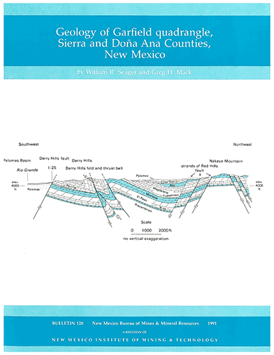
Garfield 7½-min quadrangle, approximately 25 mi south of Truth or Consequences, is located in the Rio Grande rift in south-central NM. Physiographically, the map area can be divided into three parts: (1) distal piedmont slopes of the Black Range to the west of the Rio Grande, (2) the north-south-trending Rio Grande floodplain, and (3) small, outlying fault-block hills of the Caballo Mountains and their alluvial fans, located east of the Rio Grande. Rock exposures range from Precambrian granite and syenite in the Red Hills to approximately 2,900 ft of overlying Paleozoic and lower Tertiary sedimentary strata. The upper Tertiary and lower Quaternary Rincon Valley and Palomas Formations document "early" and "late" stages in rift evolution. Upper Quaternary valley-fill alluvium records the development of the Rio Grande valley and its tributary system. Faults and folds in the Garfield quadrangle are of two ages: older ones formed during the Laramide orogeny in latest Cretaceous to early Cenozoic time and younger ones formed during evolution of the Rio Grande rift in late Tertiary and Quaternary time. Bulletin 128's two oversized sheets include four geologic cross sections, a composite columnar section, and 23 map-unit descriptions.
The Rio Grande nearly bisects the Garfield quadrangle into eastern and western halves, and I-25 parallels the eastern margin of the river's floodplain. Old US-85 also follows the river, partly along its western side and partly along its eastern side. Aside from these major highways, access to the rest of the quadrangle is limited. A good graded road, which joins I-25 at the Garfield interchange, skirts the eastern flank of the Derry Hills and ascends to the pass at the northern end of Nakaye Mountain before dropping into Green Canyon and Apache Valley. Another good graded road leaves US-85 at Derry and winds northward through desert hills parallel to I-25. From this road jeep roads and trails provide access to Nakaye Mountain, Green Canyon Dam, and the southern and central Red Hills.
On the western side of the river, jeep trails extend part of the way up Trujillo, Montoya, and Tierra Blanca Canyons. A good graded road extends from US-85 at the Rio Grande bridge southward along the river to Barrenda Canyon. It provides access to the Barrenda Creek Dam, located approximately 5 km upstream from the Rio Grande. Virtually all of the rest of the western part of the quadrangle is accessible only by foot.
$8.50
Buy
Now
Also available as a free download.
Download
| File Name | Size | Last Modified |
|---|---|---|
| Bulletin128.pdf | 9.17 MB | 01/15/2021 01:15:16 PM |
| Bulletin128_GarfieldGeoPDF.pdf | 7.46 MB | 01/15/2021 01:15:56 PM |
| GISdata: | ||
| GeMSVariationReadMe.txt | 1 KB | 08/21/2020 09:49:52 AM |
| GDB: | ||
| Garfield.gdb.zip | 10.39 MB | 08/21/2020 10:27:34 AM |
| MapPackage: | ||
| Garfield.mpk | 69.87 MB | 08/19/2020 07:58:15 AM |