


New Mexico Geological Society
Fall Field Conference Guidebook - 54
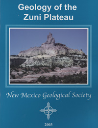
Geology of the Zuni Plateau
We are a research and service division of:
Spencer G. Lucas, Steven C. Semken, William Berglof, Dana Ulmer-Scholle, eds, 2003, 425 pages.
In the summer of 1884, Clarence Dutton (1841-1912), working for a young U. S. Geological Survey, spent two months in west-central New Mexico doing geological field work to produce a map and report on the geology of what he termed the "Zuni Plateau." This area covered approximately 7700 square miles and extended from the Rio Puerco on the east to the Arizona-New Mexico border on the west, and from Zuni Pueblo on the south to the southern end of the Chuska Mountains on the north. Dutton's report stands as a remarkable classic of New Mexico geology. Its mapping, stratigraphy and volcanology provided a solid basis for all subsequent geologic studies in the region. The first day's trip takes us around the southern flank of the Defiance uplift, back over into the southwestern San Juan Basin and ends at the Hogback monocline in Gallup. The trip emphasizes Mesozoic-especially Jurassic-stratigraphy and sedimentation in the Defiance uplift region. The second day focuses on a detailed examination of the Triassic-Jurassic section of sedimentary rocks exposed on the northern flank (dipslope) of the Zuni Mountains. This is a classic section, first described by Clarence Dutton in 1885. The field conference ends focusing on the uranium mining, mill site and tailings reclamation of the Homestake Mining Company and the late Cenozoic volcanic rocks to the northwest of Grants.
Papers from this guidebook are available for download from the NMGS website.
ISBN: 9781585460892
Softcover:
$5.00
Buy
Now
Individual papers from this guidebook are available as free downloads from the NMGS site.