


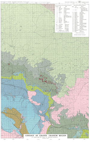
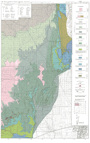
GM-31—Geologic map of Grants uranium region
We are a research and service division of:
By Chapman, Wood, and Griswold, Inc., 1974, reprinted and revised 1979, lat approx. 35°00' to 36°00', long approx. 106°30' to 109°00', 3 sheets, text, scale 1:126,720.

Shows major uranium mines and area of indicated substantial uranium mineralization in Morrison Formation. Text also printed on map.
The Grants region is the largest uranium province in the United States. Located in west-central New Mexico (southern part of Colorado Plateau), the region encompasses all of the known large uranium deposits in the state. At present the region extends from the Rio Puerco (17 mi west of Albuquerque) to northeast of Gallup (136 mi west of Albuquerque)-a distance of about 100 mi. Maximum width (northeast-southwest) is about 25 mi. The region, situated in Sandoval, Valencia, and McKinley Counties, is divided into three mining districts: Laguna on the east, Ambrosia Lake in the middle, and Church Rock (also called the Gallup district) on the west. An area composed of the eastern part of the Church Rock district and the western part of the Ambrosia Lake district is referred to by some as the Smith lake district.
Most of the region is a semiarid terrain of mesas, cuestas, and broad valleys. Lava flows are extensive between Laguna and Grants. Mount Taylor (11,301 ft), a later Tertiary volcano 18 mi northwest of Laguna, is heavily forested. The uranium-producing localities range in elevation from about 5,700 ft to about 7,400 ft.

This publication is out-of-print.
Available as a free download.
Available as a free download.
Download
| File Name | Size | Last Modified |
|---|---|---|
| GM-31_complete.zip | 31.34 MB | 02/05/2021 03:01:45 PM |
| GM-31_discussion.pdf | 401 KB | 02/05/2021 03:00:16 PM |
| GM-31_map-sheet1.pdf | 11.07 MB | 02/05/2021 03:01:11 PM |
| GM-31_map-sheet2.pdf | 10.28 MB | 02/05/2021 03:01:23 PM |
| GM-31_map-sheet3.pdf | 10.04 MB | 02/05/2021 03:01:35 PM |
| TIFF: | ||
| GM-31_map-sheet1-pal.tif | 34.49 MB | 09/14/2018 04:12:11 PM |
| GM-31_map-sheet1.tif | 206.70 MB | 09/14/2018 04:06:54 PM |
| GM-31_map-sheet2-pal.tif | 31.88 MB | 09/14/2018 04:22:08 PM |
| GM-31_map-sheet2.tif | 203.71 MB | 09/14/2018 04:21:50 PM |
| GM-31_map-sheet3-pal.tif | 27.18 MB | 09/14/2018 04:28:26 PM |
| GM-31_map-sheet3.tif | 157.57 MB | 09/14/2018 04:27:42 PM |