


Overview of Fresh and Brackish Water Quality - San Luis Basin
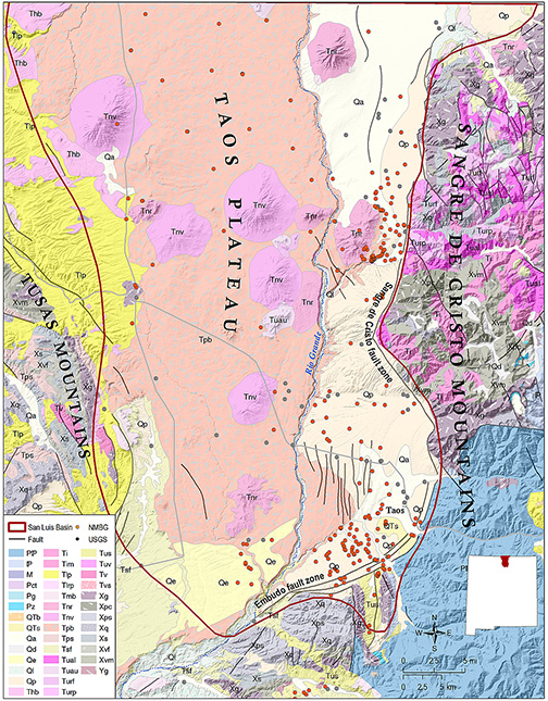
The San Luis Basin is the northernmost and largest basin of the Rio Grande Rift system in New Mexico. Most of the basin is located in Colorado, where it merges to the north with the Upper Arkansas River graben (Grauch and Keller, 2004). The basin is ~150 miles long and 55 miles wide, and has the general form of an east-dipping half graben. Basin-fill material is composed of Tertiary-Quaternary sediments of the Santa Fe Group and late Cenozoic volcanics (Kelley et al., 1976). The basin is bounded to the west by the Tusas and San Juan Mountains and to the east by the Sangre de Cristo Mountains and the Sangre de Cristo fault zone. The deepest part of the basin is found in the Taos graben, a narrow zone 6 to 18 miles wide adjacent to the Sangre de Cristo mountain front (Grauch and Keller, 2004). The southern part of the basin is occupied by the Taos Plateau, which is composed of Pliocene basalt flows that overlie Santa Fe Group basin fill. The southeastern margin of the basin is defined by the Embudo fault zone, which separates the east-tilted San Luis Basin from the west-tilted Española Basin to the south (Bauer and Kelson, 2004).
Both a shallow and a deep aquifer system have been identified in the San Luis Basin. The shallow aquifer system consists of unconsolidated Quaternary fluvial and alluvial fan deposits, overlying and interbedded with basalt flows of the Servilleta Formation. A few wells yield water from fractured Paleozoic carbonates and Precambrian crystalline rocks along the Sangre de Cristo mountain front. These local aquifers are hydraulically connected to the shallow alluvial aquifer system. The deeper aquifer system is associated with Tertiary basin-fill material, consisting of weakly to moderately cemented fluvial, alluvial fan and volcaniclastic sediments that underlie the Servilleta Formation (Drakos et al., 2004a; 2004b). The deep aquifer, where investigated, is >2,000 feet thick, but is probably substantially thicker in the Taos graben, which has a depth of ~16,000 feet (Bauer and Kelson, 2004).
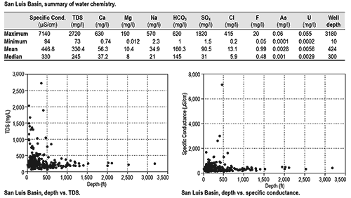
Our data set includes 300 records for the San Luis Basin, which show that water quality in both the shallow and deep aquifers is generally good, with mean and median values of TDS <500 mg/l, and mean chloride concentrations of only 13.1 mg/l. Locally elevated levels of arsenic and fluoride have been observed in wells completed in the deep aquifer (Drakos et al., 2004b). The data set also show locally elevated levels of uranium. There is little evidence that deep brackish water resources are present in the San Luis Basin. However, the mean well depth in this region is only 424 feet. Considering the very substantial thickness of basin fill, if such a resource is present it remains largely uninvestigated.
This project is funded by the New Mexico Environment Department, Drinking Water Bureau, under Source Water Protection.
For more information:
see: Overview of Regional Brackish Water Assessments
or contact:
Lewis Land — Hydrogeologist, lland@nckri.org
References
- Land, Lewis, 2016, Overview of Fresh and Brackish Water Quality in New Mexico - San Luis Basin, Summary sheet.
- Land, Lewis, 2016, Overview of Fresh and Brackish Water Quality in New Mexico, New Mexico Bureau of Geology Mineral Resources, Open-file Report, v. 0583, pp. 55.