


New Mexico: Regional Brackish Water Assessments
As New Mexico considers the use of desalinated brackish water (less than 10,000 mg/L total dissolved solid) to diversify the public water supply, many questions must first be answered. Where are the brackish water resources? What data are available? What exactly is the water chemistry? How feasible is it to use brackish water for public supply?
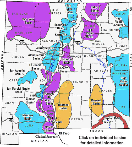
Brackish Water Aquifers
(listed in order of decreasing water quality)
- San Luis Basin
- San Agustin Basin
- Española Basin
- Mimbres Basin
- San Marcial & Engle Basins
- Albuquerque Basin
- High Plains Aquifer
- Socorro & La Jencia Basins
- Mesilla Basin
- Estancia Basin
- Palomas Basin
- Jornada del Muerto Basin
- Raton & Las Vegas Basins
- San Juan Basin
- Tularosa Basin
- Roswell Artesian Basin
- Capitan Reef Aquifer
With funding from the New Mexico Environment Department, Drinking Water Bureau (related to Source Water Protection), the New Mexico Bureau of Geology, Aquifer Mapping Program, has compiled a number of water quality resources and data. These data were derived from the Aquifer Mapping Program, digitized historical water reports, the U.S. Geological Survey, and the New Mexico Environment Department. All publicly available data are now on an interactive map found here, under Water Resources: maps.nmt.edu.
For an analysis and review of the compiled water quality data, we have attempted to assess the brackish water resources in New Mexico in a regional approach. It is apparent that very large regions of the state lack sufficient data to assess brackish water resources. Most of the data compiled in this review are from existing water supply wells, and therefore are not representative of brackish water. These data also represent, in general, the shallowest parts of the aquifers where water wells are commonly completed.
Each of the regions of assessment shown on the map are provided in individual chapters for quick review. These chapters are part of a larger technical report is available from the New Mexico Bureau of Geology and Mineral Resources.
This project is funded by the New Mexico Environment Department, Drinking Water Bureau, under Source Water Protection.
For more information, please contact:
Dr. Lewis Land — Hydrogeologist
or
Stacy Timmons — Associate Director for Hydrogeology Programs
AMP-Relevant Publications
- Land, Lewis; Timmons, Stacy, 2016, New Mexico: A Brackish Water Data Assessment, Fact Sheet (2MB).
- Land, Lewis, 2016, Overview of Fresh and Brackish Water Quality in New Mexico, New Mexico Bureau of Geology Mineral Resources, Open-file Report, v. 0583, pp. 55.