


Overview of Fresh and Brackish Water Quality - Mimbres Basin
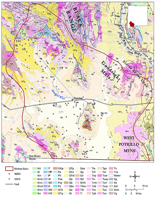
The Mimbres Basin is a structurally complex region in southwestern New Mexico, extending over an area of more than 5,000 square miles in parts of Grant, Luna, Doña Ana and Sierra Counties, and straddling the border with the Mexican Republic. The region has been subject to extensive geologic, geophysical, and hydrologic investigations over a period of almost a century, including Darton (1916), White (1931), Trauger (1972), Hanson et al. (1994), Hawley et al. (2000), and Kennedy et al. (2000). The Mimbres Basin is located at the intersection of the Basin and Range, southern Rio Grande Rift, and southern Transition Zone tectonic provinces (Mack, 2004). Dominant structural features in the region are northwest trending faults and folds associated with the Laramide orogeny, Tertiary magmatism and Quaternary tectonism (Finch et al., 2008). The greater Mimbres Basin is made up of an interconnected group of hydrologic sub-basins separated by fault-bounded uplifts, bounded to the east by the Goodsight Mountains, Sierra de las Uvas, and basalt flows and cinder cones of the West Potrillo Mountains. The Continental Divide defines the northern and western boundaries of the Mimbres Basin. The only major surface drainage in the basin is the Mimbres River (Hawley et al., 2000; Connell et al., 2005; Finch et al., 2008).
Principal water-bearing units in the Mimbres Basin region include Paleozoic carbonate rocks, Cretaceous sedimentary rocks, Tertiary volcanics and volcaniclastic rocks, and a basin-fill aquifer composed of Tertiary to Quaternary Gila Conglomerate and Quaternary alluvium (Finch et al., 2008). Thickness of the basin fill varies from 2,000 to 5,000 feet in the deep structural sub-basins, although productive water-bearing zones usually only occur in the upper 600–1,000 feet of the basin fill sequence (Hawley et al., 2000). Groundwater recharge occurs from direct precipitation, and by mountain-front recharge from infiltration of redistributed runoff through alluvial fans along the basin margins. Regional groundwater flow is predominantly from the northern highlands to the interior basins, and southward toward the Mexican border (Hawley et al., 2000; Finch et al., 2008).
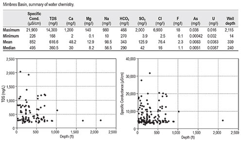
Data distribution in the Mimbres Basin region is sparse (only 265 total data points) and irregularly distributed. A variety of hydrochemical facies have been identified that reflect the complex and varied lithologies that make up the aquifer systems in the basin. This complexity contributes to an irregular distribution of salinity in the Mimbres Basin, varying from fresh to moderately saline (Hawley et al., 2000), with a mean TDS of only 616 mg/l and average chloride concentrations <80 mg/l. Groundwater in the northern part of the basin is relatively fresh (<500 mg/l), while salinities greater than 1,000 mg/l are found in the southern part of the basin. A maximum TDS value of 14,300 mg/l was measured from an unknown depth in an isolated well located near the Mexican border, near the down-gradient end of the system. This distribution of salinity suggests that brackish water resources may be present at depth in the southern Mimbres Basin, but with a mean well depth of only 339 feet those potential resources have been largely uninvestigated.
This project is funded by the New Mexico Environment Department, Drinking Water Bureau, under Source Water Protection.
For more information:
see: Overview of Regional Brackish Water Assessments
or contact:
Lewis Land — Hydrogeologist, lland@nckri.org
References
- Land, Lewis, 2016, Overview of Fresh and Brackish Water Quality in New Mexico - Mimbres Basin, Project Summary Sheet.
- Land, Lewis, 2016, Overview of Fresh and Brackish Water Quality in New Mexico, New Mexico Bureau of Geology Mineral Resources, Open-file Report, v. 0583, pp. 55.