


Overview of Fresh and Brackish Water Quality - Roswell Artesian Basin
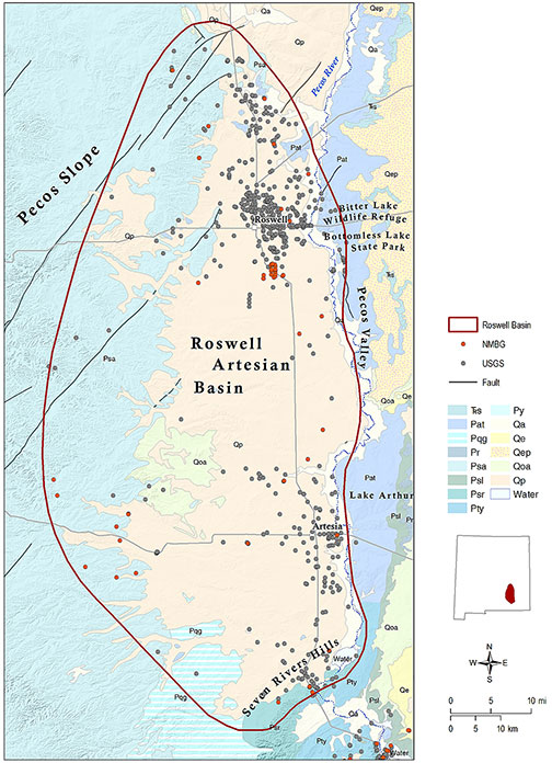
The Roswell Artesian Basin occupies over 4,000 square miles in the lower Pecos Valley in Chaves and northern Eddy Counties, and is one of the most intensively farmed regions in the state outside the Rio Grande Valley (Welder, 1983; Land and Newton, 2008). The eastern margin of the basin occurs just east of the Pecos River; the northern boundary is approximately defined by Macho Draw north of Roswell; and the southern end of the basin is located at the Seven Rivers Hills north of Carlsbad. The western margin of the basin is not as well-defined, but is usually located west of Roswell on the Pecos Slope near the Chaves-Lincoln County Line. The basin derives virtually all of its irrigation and drinking water from groundwater stored in a karstic artesian limestone aquifer contained within the Permian San Andres and Grayburg Formations, and from a shallow unconfined aquifer composed of Tertiary-Quaternary alluvial material deposited by the ancestral Pecos River. The Roswell Basin has been described by many workers as a world-class example of a rechargeable artesian aquifer system (e.g., Fiedler and Nye, 1933; Havenor, 1968).
The recharge area for the basin has been conventionally located within the San Andres limestone outcrop area, on the Pecos Slope in western Chaves County, where east-flowing streams originating in the Sacramento Mountains lose their water through sinkholes and solution-enlarged fissures. (Fiedler and Nye, 1933; Land and Huff, 2010). However, recent work has shown that a substantial portion of groundwater recharge to the basin originates in the southern Sacramento Mountains to the west, and enters the artesian aquifer by underflow from the underlyingYeso Formation (Rawling and Newton, 2016; Land and Timmons, 2016). The San Andres aquifer is unconfined in the western outcrop area, and becomes pressurized when it dips into the subsurface west of Roswell and passes beneath gypsum confining beds of the Seven Rivers Formation (Land and Newton, 2008).
Most discharge from the artesian and shallow aquifers is from irrigation wells, although substantial natural discharge occurs from karstic springs and sinkhole lakes that line both sides of the Pecos River at Bitter Lake National Wildlife Refuge and Bottomless Lakes State Park (Land, 2003; Land and Newton, 2008; Land and Huff, 2010). East of the Pecos River the San Andres limestone is an oil and gas reservoir, and the same interval that produces potable water for the city of Roswell contains oil and brine with chloride concentrations as high as 39,000 mg/l (Havenor, 1968; Gratton and LeMay, 1969).
Personnel from the Pecos Valley Artesian Conservancy District (PVACD) measure chloride concentrations and other water quality parameters in selected wells twice a year, thus water quality and salinity distribution in the Roswell Artesian Basin are well-constrained. Mineral content of groundwater in the artesian aquifer increases downgradient to the east toward the Pecos River, and a well-defined freshwater-saltwater interface has been mapped beneath the city of Roswell (Land and Newton, 2007). Chloride concentrations range from 15 mg/l in the unconfined, western part of the aquifer to as high as 7,000 mg/l in a flowing artesian well east of the city. Discharge from that well was used as feedstock for a pilot desalination facility in the mid-20th century. That facility is now closed, but legacy water quality data from wells in the vicinity of the plant are included in our water chemistry records.
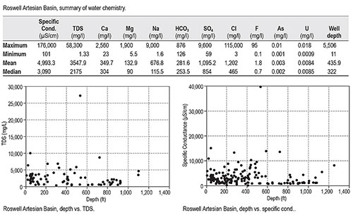
TA substantial data set is available for the Roswell Basin, with 632 total records. Our data show that basin-wide salinity is very high, with a mean TDS content >3,500 mg/l. However, this mean value is influenced by several samples that were collected in the vicinity of the pilot desalination facility in the saline portion of the artesian aquifer. The highest TDS concentration in the basin (58,300 mg/l) was measured in a well of unknown depth immediately east of the desalination plant. Data collected from oil and gas wells in the region also influence our records. Maximum chloride concentrations were measured in an oil test well south of Artesia drilled in 1957, and maximum well depth (5,506 feet) is from an exploratory well drilled between Artesia and Lake Arthur in 1950.
A substantial volume of brackish water resources is available in the Roswell Artesian Basin, and those resources were exploited in the mid-20th century to evaluate desalination technologies. Previous work has shown that TDS and chloride concentrations increase with depth in the aquifer, although this relationship is not well defined in plots of TDS and specific conductance vs. depth based on our records. Hood (1963) reported that in the vicinity of Artesia, a difference of just 100–200 ft in well depth can mean a difference of several hundred mg/l in chloride concentration. However, lateral variations in mineral content are more relevant than depth in characterizing the distribution of salinity in the Roswell Basin.
This project is funded by the New Mexico Environment Department, Drinking Water Bureau, under Source Water Protection.
For more information:
see: Overview of Regional Brackish Water Assessments
or contact:
Lewis Land — Hydrogeologist, lland@nckri.org
References
- Land, Lewis, 2016, Overview of Fresh and Brackish Water Quality in New Mexico - Roswell Artesian Basin, Project Summary Sheet.
- Land, Lewis, 2016, Overview of Fresh and Brackish Water Quality in New Mexico, New Mexico Bureau of Geology Mineral Resources, Open-file Report, v. 0583, pp. 55.