


Overview of Fresh and Brackish Water Quality - San Juan Basin
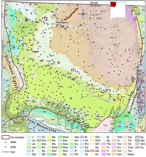
The San Juan Basin is a large structural basin in northwestern New Mexico that formed during the late Cretaceous-Paleogene Laramide orogeny about 75 million years ago. The basin comprises all or parts of San Juan, McKinley, Rio Arriba, and Sandoval Counties, with a northern portion that extends into southwestern Colorado. The basin is bordered by basement-cored Laramide highlands, including the Nacimiento Uplift to the east, the Zuni Mountains to the south, the Defiance uplift to the west, and the San Juan Mountains in Colorado to the north. Laramide-age monoclines form the remaining boundaries of the basin (Kelley et al., 2014). The San Juan Basin region is a major producer of hydrocarbons, primarily natural gas, and extensive studies of the petroleum geology of the region have been conducted over the past several decades. Basin-wide hydrogeological assessments of the San Juan Basin were conducted by Stone et al. (1983), Craigg et al. (1989; 1990), Kaiser et al. (1994), Kernodle (1996), and Levings et al. (1996). Kelley et al. (2014) conducted a thorough hydrologic assessment of oil and gas resource development of the Mancos Shale in the San Juan Basin, which includes detailed discussions of groundwater salinity in the basin by depth and individual aquifers.
The principal water-bearing units in the San Juan Basin are contained in Cretaceous sandstones that were deposited in a marginal marine setting along the southwest margin of the Western Interior Seaway; non-marine Jurassic sandstones of the Morrison, Entrada and Bluff Formations; and non-marine Tertiary sandstone aquifers. Recharge to these aquifers, some of which are also natural gas reservoirs in the center of the basin, occurs in narrow outcrop belts along the basin margin, and also from the San Juan Mountains and Nacimiento Uplift to the north and east (Kelley et al., 2014). The Permian Glorieta sandstone and San Andres limestone are also important sources of groundwater along the northern margin of the Zuni Mountains (Stone et al., 1983).
Kelley et al. (2014) report that groundwater salinity derived from borehole geophysical logs is generally low along the basin margins, where recharge occurs, and high toward the center of the basin for all aquifers considered in their investigation. Some units, such as the Gallup and Morrison Formations, have particularly broad zones of fresher water along the southern and western margins of the basin. However, the distribution of saline water toward the basin center is complex and variable among the different aquifers.
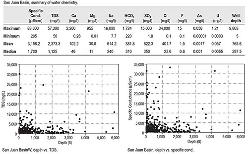
We have an exceptionally large data set for the San Juan Basin (1,011 total data points). Some of the wells sampled are apparently natural gas or oil wells, as indicated by their depth, several of which exceed 4,000 feet. Unlike most of the other basins included in this report, data from the San Juan Basin show evidence of higher TDS values at greater depths. Basin-wide TDS values are high, with a mean of >2300 mg/l, suggesting there could be significant resources of brackish water at depth toward the center of the San Juan Basin. Uranium levels are also elevated, with a mean value of 0.057 mg/l, well in excess of the EPA MCL of 0.03 mg/l. The highest measured uranium level, 1.21 mg/l (40 times greater than the EPA MCL for that constituent), was sampled at what appears to be a surface mining operation between Gallup and Crownpoint.
This project is funded by the New Mexico Environment Department, Drinking Water Bureau, under Source Water Protection.
For more information:
see: Overview of Regional Brackish Water Assessments
or contact:
Lewis Land — Hydrogeologist, lland@nckri.org
References
- Land, Lewis, 2016, Overview of Fresh and Brackish Water Quality in New Mexico - San Juan Basin, Project Summary Sheet.
- Land, Lewis, 2016, Overview of Fresh and Brackish Water Quality in New Mexico, New Mexico Bureau of Geology Mineral Resources, Open-file Report, v. 0583, pp. 55.