


Cookes Peak
We are a research and service division of:
Introduction
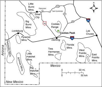
As a crow flies, Cookes Peak is located approximately 17 miles north of Deming (Figure 1). The peak can be accessed from Deming by driving northeast on New Mexico Highway 26 about 13.5 miles to Cookes Canyon Road NE, which is marked by a green street sign on the left side of the road. This road is also known as County Road A019. Travel northwest on the dirt road about 12.5 miles and park near the foot of the mountain. A high-clearance vehicle is strongly recommended. The peak is on BLM land.
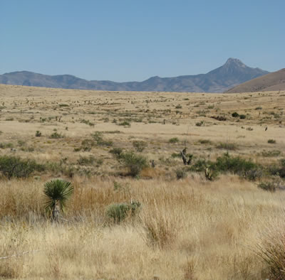
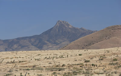
The craggy gray granodiorite spire of Cookes Peak, the highest point in the Cookes Range at 8,404 feet, is a prominent landmark in southwestern New Mexico (Figures 2 and 3). Cookes Spring on the southeast side of the range is one of just a few perennial springs in this part of New Mexico; consequently, this peak was an important marker of water for Native American, Spanish, and American travelers through the region during the 19th century (Julyan, 2006). The peak was named for Captain Phillip St. George Cooke, who led the Mormon Battalion through southern New Mexico during the winter of 1846 while scouting an overland wagon route for the U.S. Army. Later, a Pony Express mail station was established near the spring. Fort Cummings was built nearby in 1863 to protect travelers from Apache attacks; the fort was manned by the U.S. Army off and on until Geronimo surrendered in 1886. Ruins of the Cookes Spring Station of the Butterfield Trail and Fort Cummings are located about a mile south of the present-day Hyatt Ranch.
Ed Orr, a prospector, discovered silver north of the peak in 1876, but prospectors Taylor and Wheeler were the first to find profitable ore bodies in 1880 (Darton, 1916). Economic mineral deposits in the Cookes Range include galena (lead), sphalerite (zinc), silver, copper, gold, manganese, and fluorite. The Cookes Peak mining district was quite productive through the years. According to McLemore et al. (2001), this district was 5th in the state in overall lead production and 9th in zinc production.
Regional Setting
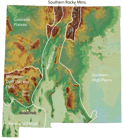
Cookes Peak lies in the Basin and Range Province just south of the the Mogollon-Datil volcanic field near the western margin of the Rio Grande rift (Figure 4). The Mogollon-Datil volcanic field straddles the transitional boundary between the tectonically stable Colorado Plateau to the north and the extensional terrane of the Basin and Range to the south.
The granodiorite intrusion that forms Cookes Peak is associated with volcanism in the Mogollon-Datil field, which was active between 24 to 40 million years ago. Younger Basin and Range extensional faulting has since brought this intrusion to the surface to be carved by erosion into the notable landmark that we see today.
Geologic History
The geologic story preserved in the Cookes Range is remarkable in that the record is nearly complete; the section includes rocks ranging from Proterozoic to late Cenozoic in age (Figures 5 and 6). Like many mountain ranges in this part of southwestern New Mexico, early Mesozoic rocks (Triassic-Jurassic) are absent because sedimentary rocks of this age were never deposited or were eroded. This region was a rift-flank highland during early Mesozoic time (Figure 7).
The oldest rock is coarse-grained Proterozoic granite exposed at the northern end of the south-dipping mountain range. These ancient rocks have been moderately altered by younger volcanism, so we know little about them – we do not know the age, geochemical makeup, or tectonic setting of emplacement of this intrusion. Jicha (1954) mentions that the granite is gneissic in places, which suggests that parts of the Proterozoic basement in the Cookes Range may be 1.6 to 1.7 billion years old.
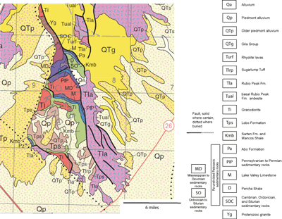
The Cambrian Bliss Formation, a purplish-brown sandstone deposited along the shore of a shallow tropical ocean approximately 500 million years ago (Evans and Clemons, 1987; Matheny et al., 1988), rests on the Proterozoic rocks. At least 650 million years of Earth’s history is missing from the rock record across the Great Unconformity between the Proterozoic basement and the Cambrian strata in this area. Sea level continued to rise over the course of the next 20 million years, leading to deposition of carbonates on top of the sandy Bliss Formation. The dolomite and limestone in the Ordovician-to-Silurian El Paso Formation, Montoya Formation, and Fusselman Dolomite were deposited in a warm, shallow ocean along a tectonically stable, southward-sloping continental shelf between 480 and 425 million years ago. Erosional breaks in the rock record occur between the El Paso and the Montoya and between the Montoya and the Fusselman (Jicha, 1954). In general few fossils are preserved in these units. The Ordovician carbonates contain trilobites, gastropods, brachiopods, crinoids, bryozoans, and corals; the Fusselman Dolomite has the occasional brachiopod or coral (Jicha, 1954).
The Middle Silurian Fusselman Dolomite and the Upper Devonian Percha Formation are separated by a significant unconformity. The Percha Formation, characterized by black shale intercalated with thin discontinuous beds and nodules of gray limestone, was deposited between 385 and 360 million years ago in seawater that contained little oxygen. Fossils are very rare in the Percha Formation. The Mississippian Lake Valley Limestone, a light gray limestone with a few shale beds, gradationally overlies the Percha Shale. The Lake Valley Limestone is quite fossiliferous and contains the remains of bryozoans, crinoids, and brachiopods, indicating that the amount of oxygen in the shallow marine waters returned to life-supporting levels 360 and 340 million years ago.
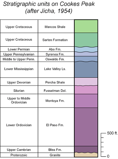
A significant time gap is associated with the conformable contact between the Mississippian Lake Valley Limestone and the overlying Pennsylvanian Oswaldo Formation. The Oswaldo Formation is a cherty limestone with a few beds of shale and sandstone. This unit grades up into the Pennsylvanian Syrena Formation, a shaly limestone and limy shale. Brachiopods, fusilinids, and coral fossils are common in these strata. The Pennsylvanian units were deposited in shallow seas on a southward-deepening continental shelf about 300 to 310 million years ago (Kues and Giles, 2004). The ocean retreated to the south during Permian time. The fluvial Permian Abo Formation, composed of reddish-brown sandstone and shale with thick lenses of chert pebble to limestone cobble conglomerate in a limestone matrix, unconformably overlies the marine Pennsylvanian rocks. The chert pebbles in the Abo Formation conglomerates range in color from white, gray, and black to red (Jicha, 1954). Thin beds of limestone are also present in the Abo Formation in this area (Lucas et al., 1988). The 295-to-300 million-year-old Permian rivers generally flowed to the south (Kues and Giles, 2004).
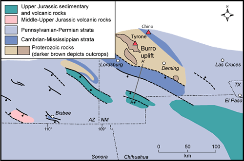
The Early Mesozoic section was either never deposited on or was eroded from the Cookes Range because this area was a highland on the flank of a northwest-trending Jurassic rift basin known as the Bisbee Basin (Figure 7; Lawton, 2000). Upper Cretaceous rocks lapped onto and buried the rift shoulder. Upper Cretaceous Sarten Formation, a succession of gray shale, siltstone and sandstone with a few lenses of pebble conglomerate, unconformably overlies Permian Abo Formation in this area (Jicha, 1954; Mack et al., 1988; Lucas et al., 1988). Lag gravels containing limestone and chert pebbles are present at the base and at the top of the Sarten Formation (Mack et al., 1988). Fossil ammonites, coral, clams and snails are found in the lower part of the Sarten Formation, and oysters, clams, snails, and ammonite fragments are preserved in the upper Sarten Formation (Lucas et al., 1988; Cobban et al., 1989). The Mancos Shale, which is composed of dark gray to black shale with thin gray limestone and tan sandstone beds, unconformably overlies the Sarten Formation. Ammonite, oysters, and clams are common fossils found in the Mancos Shale (Lucas et al., 1988; Cobban et al., 1989). Lucas et al. (1988) note that fossil fish teeth, particularly from selachians (sharks, rays, and skates), are abundant in the Bridge Creek Limestone Member of the Mancos Shale on Rattlesnake Ridge south of Cookes Peak. The Upper Cretaceous rocks preserve a history of the oscillating landward and seaward migration of the shoreline of the Western Interior Seaway across this area about 90-to-105 million years ago (Mack et al., 1988).
Laramide compressional deformation affected southern New Mexico 50-to-60 million years ago, creating a series of northwest-striking highlands and basins (Clemons and Mack, 1988; Mack and Clemons, 1988). Conglomerate, sandstone, and mudstone of the Paleocene to Eocene Lobo Formation accumulated in a northwest-trending basin preserved in the southern Cookes Range. The conglomerates were derived from the Laramide-age Burro uplift, which was located to the southwest of the Cookes Range in the vicinity of Deming and the Florida Mountains.
Cretaceous and older sedimentary rocks were subsequently invaded by several generations of intrusions, some of which were barren and some of which were enriched with ore-generating fluids. The craggy top of Cookes Peak is composed of a granodiorite stock that is 38.8 ± 1.1 million years old, based on a K-Ar date determined by Loring and Loring (1980). A granodiorite intrusion of similar age (38.82±0.57 Ma) is exposed on Fluorite Ridge south of the peak (McLemore et al., 2001). Basaltic-to-dacitic dikes and sills in the southern Cookes Range are 37.6±2.0 to 44.7± 1.9 million years old (Clemons, 1982). These Eocene intrusives are associated with early volcanic activity in the Mogollon-Datil volcanic field to the north. A bit later, the Eocene Rubio Peak Formation, a thick sequence of andesitic to dacitic lava flows and interbedded volcaniclastic sediments derived from volcanoes to the north of Cookes Peak in the Mogollon-Datil volcanic field, lapped onto the older rocks in the region. Interestingly, Jicha (1954) reports that sandstones at the base of the Rubio Peak Formation contain pebbles of granodiorite. The exact age of the Rubio Peak Formation has not yet been determined, but we do know that the unit was deposited before 35.17±0.12 million years ago, based on the age of the overlying Sugarlump Tuff (McIntosh et al., 1991). The regionally extensive ash-flow tuffs that erupted from calderas in the Mogollon-Datil volcanic field are, in general, not preserved in this area; only one small remnant outcrop of Sugerlump Tuff sits on Rubio Peak Formation in the southern Cookes Range.
Extension began in this region about 36 million years ago, forming the Basin and Range topography that we see today. The rising Cookes Range block was bounded on three sides by normal faults and was generally tilted toward the south, so that older rock units are exposed on the northern end of the range. A subalkaline basalt flow of uncertain age that likely was erupted during Basin and Range extension is exposed in Fort Cummings Draw in the southeastern Cookes Range (Anthony et al., 1992). Large alluvial fans were subsequently deposited around the eroding mountain block during Miocene to Pliocene time. This process continues today.
Mineralization
The Cookes Peak granodiorite stock was the source of the mineralizing fluids in the Cookes Peak mining district (Jicha, 1954). The lead-zinc-silver deposits form tabular to cylindrical-shaped replacement ore bodies along northeast-striking fractures and faults at or irregularly shaped bodies just below the contact between the Fusselman Dolomite and Percha Shale (Jicha, 1954). The irregularly shaped ore bodies are often lead carbonate with a core of galena or fluorite (Jicha, 1954). Jasperoid, which forms when silica-enriched fluids replace carbonate with quartz, is common in the Fusselman Dolomite just underneath the impermeable Percha Shale. The jasperoid can contain fluorite, calcite, quartz, pyrite, and cerrusite (an oxidized lead mineral) (McLemore et al., 2001).
McLemore et al. (2001) note that geodes can be found in rhyolitic tuff exposed north of Fort Cummings and agate is common throughout the Cookes Peak district.
References
- Anthony E.Y., Hoffer J.M., Waggoner W.K., and Chen W., 1992, Compositional diversity in Late Cenozoic mafic lavas in the Rio Grande Rift and Basin and Range Province, southern New Mexico. Geologic Society of America Bulletin, v. 104, p. 973-979.
- Clemons, 1982, Geology of Massacre Peak quadrangle, Luna County, New Mexico: New Mexico Bureau of Mines and Mineral Resources, Geologic Map 51, scale 1:24,000.
- Clemons, R. E., and Mack, G. H., 1988, Geology of southwestern New Mexico, in Mack, G. H., Lawton, T. F., and Lucas, S. G., ed., Cretaceous and Laramide evolution of southwestern New Mexico, New Mexico Geological Society, Guidebook 39, p. 45-57.
- Cobban, W. A., Hook, S. C., and Kennedy, W. J., 1989, Upper Cretaceous rocks and ammonite faunas of southwestern New Mexico, New Mexico Bureau of Mines and Mineral Resources, Memoir 45,137 p.
- Darton, N.H., 1916, Geology and underground water of Luna County, New Mexico: U.S. Geological Survey Bulletin 618, 188 p.
- Evans, K.V., and Clemons, R.E., 1987, U-Pb geochronology of the Florida Mountains New Mexico: new evidence for latest Cambrian-earliest Ordovician alkali plutonism: Geological Society of America Abstracts with Programs, v. 19, p. 657-658.
- Jicha, H.L.,Jr., 1954, Geology and mineral deposits of Lake Valley quadrangle, Grant, Luna, and Sierra Counties, New Mexico: New Mexico Bureau of Mining and Mineral Resources Bulletin 37, 93 p.
- Julyan, R., 2006, The Mountains of New Mexico: University of New Mexico Press, Albuquerque, NM, p. 245.
- Kues, B.S., and Giles, K.A., 2004, The late Paleozoic Ancestral Rocky Mountains System in New Mexico, in Mack, G.H. and Giles, K.A., editors, The Geology of New Mexico: A Geologic History: New Mexico Geological Society Special Publication 11, p. 95-136.
- Lawton, T.F., 2000, Inversion of Late Jurassic-Early Cretaceous extensional faults of the Bisbee Basin, southeastern Arizona and southwestern New Mexico: New Mexico Geological Society Guidebook, 51st Fall Field Conference, p. 95-102.
- Loring, A. K., and Loring, R. B., 1980, K/Ar ages of Middle Tertiary igneous rocks from southern New Mexico: Isochron/West, no. 28, p. 17-19.
- Lucas, S. G., Kues, B. S., Hayden, S. N., Allen, B. D., Kietzke, K. K., Williamson, T. E., Sealy, P., and Pence, R., 1988, Cretaceous stratigraphy and biostratigraphy, Cooke's Range, Luna Country, New Mexico, in Mack, G. H., Lawton, T.F., and Lucas, S.G., ed., New Mexico Geological Society, Guidebook 39, p. 143-167.
- Mack, G.H., and Clemons, R.E., 1988, Structural and stratigraphic evidence for the Laramide (early Tertiary) Burro uplift in southwestern New Mexico: in Mack, G. H., Lawton, T.F., and Lucas, S.G., ed., New Mexico Geological Society, Guidebook 39, p. 59-66..
- Mack, G. H., Galemore, J. A., and Kaczmarek, E. L., 1988a, The Cretaceous foreland basin in southwestern New Mexico, in Mack, G. H., Lawton, T. F., and Lucas, S. G., ed., Cretaceous and Laramide tectonic evolution of southwestern New Mexico, New Mexico Geological Society, Guidebook 39, p. 135-141.
- Matheny, R.K., Shafiqullah, M., Brookins, D.G., Damon, P.E., and Wallin, T., 1988, Geochronologic studies of the Florida Mountains, New Mexico: New Mexico Geological Society Guidebook 39, p. 99-107.
- McIntosh, W.C., Kedzei, L.L., and Sutter, J.F., 1991, Paleomagnetism and40Ar/39Ar ages of ignimbrites, Mogollon-Datil volcanic field, southwestern New Mexico: New Mexico Bureau of Mines and Mineral Resources Bulletin 135, 79 p.
- McLemore, V.T., Donahue, K., Breese, M., Jackson, M.L., Arbuckle,J. and Jones, G., 2001, Mineral resource assessment of Luna County, New Mexico: New Mexico Bureau of Geology and Mineral Resources Open-file Report OF-459, 85 p.