


Monument Rock
We are a research and service division of:
Location
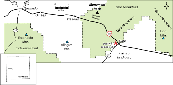
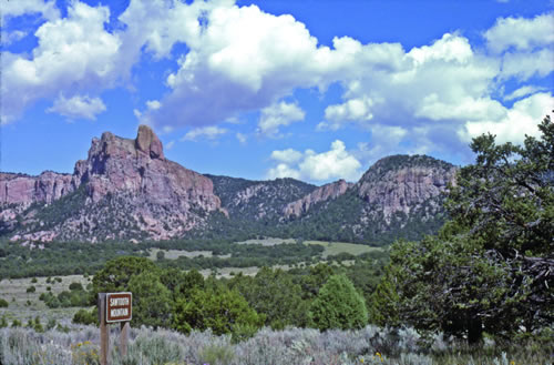
Monument Rock is located west of Socorro and north of U.S. Highway 60 in the eastern Sawtooth Mountains of Catron County, New Mexico (Figure 1). The area can be reached from Datil by traveling west along Highway 60, 12.3 miles to Forest Road 6A. Turn right on Forest Road 6A and drive north 3.7 miles to the prominent spire of Monument Rock (Figure 2).
The area can also be accessed from Pie Town by driving east along U.S. Highway 60 to Forest Road 316. Turn left onto Forest Road 316 and drive northeast 3.5 miles to Forest Road 6A. Turn left and drive 1.1 miles to Monument Rock.
Regional Geologic Setting
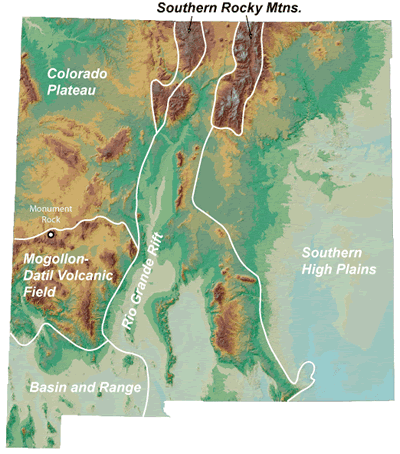
The northern sedimentary apron derived from the Mogollon–Datil volcanic field laps across the southern margin of the tectonically-stable Colorado Plateau in the vicinity of Monument Rock (Figure 3). The Mogollon–Datil volcanic field is made up of lavas and tuffs that erupted from andesitic to silicic volcanoes, domes, and calderas 24 to 40 million years ago. The rocks in the vicinity of Monument Rock are composed of debris eroded from the volcanic highlands to the south. Sediment-choked streams flowing toward the north deposited the fluvial sandstones of the lower Dog Springs Formation near Datil and Quemado (Figure 1) about 37 million years ago (Chamberlin and Harris, 1994). The upper Dog Springs Formation in the Sawtooth, Datil, and Gallinas mountains (Figure 1) consists of debris flows and breccias composed of clasts of andesite and dacite. The debris flows locally contain large slabs of Pennsylvanian limestones north of Datil (Chamberlin et al., 1994). Lateral east-west changes in the size of the boulders and cobbles in the unit suggest that the major eruptive center that shed most of the Dog Springs Formation was probably located south of Datil, under what is now the southern Plains of San Agustin (Figure 1).
The sedimentary rocks are tilted gently to the south about 2 degrees. Chamberlin et al. (1994) speculate the southward dip is caused by the weight of the voluminous volcanic rocks of the Mogollon–Datil volcanic field loading and depressing the earth’s crust. Alternatively, uplift of the Colorado Plateau relative to the volcanic field after 24 million years ago could also result in a southward dip.
Geologic History
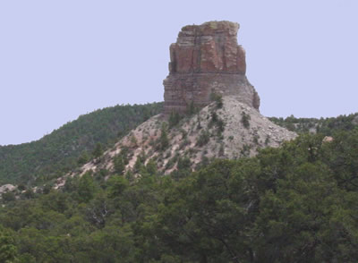
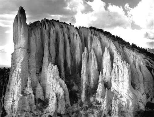
Monument Rock is an erosional pillar of undeformed 37-million-year-old volcaniclastic conglomeratic sandstone beds that contain andesitic-to-dacitic clasts (Figure 2). The most interesting geologic feature in the area is preserved in cliffs to the northeast of Monument Rock (Figure 4) on a hill with spot summit elevation of 8919 (topographic map; informally called "Peak 8,919" by Chamberlin et al., 1994). Complexly contorted volcaniclastic sandstone and debris flows are exposed in the cliffs. The deformation occurred while the water-saturated sediments of the Dog Springs Formation were still soft, before the sand, gravel, and silt were converted to hard sandstone, conglomerate, and siltstone by burial and cementation. The soft sediment deformation may record regional-scale liquifaction of the sandstone and conglomerate following a large earthquake that occurred in late Eocene time (Chamberlin et al., 1994). Soft sediment deformation in the late Eocene Dog Springs Formation has been observed between the eastern Gallinas Mountains northeast of Datil and the Escondido Mountain area southwest of Quemado, across a distance of ~60 miles (Figure 1). Notably, Monument Rock is a rare example of undeformed beds (i.e., nearly horizontal beds) in the lower Dog Springs Formation.
References
- Chamberlin, R. M., and Harris, J. S., 1994, Upper Eocene and Oligocene volcaniclastic sedimentary stratigraphy of the Quemado–Escondido Mountain area, Catron County, New Mexico: New Mexico Geological Society, Guidebook 45, pp. 269–275.
- Chamberlin, R. M., Cather, S. M., McIntosh, W. C., Anderson, O. J., and Rattè, J. C., 1994, First-day road log from Socorro to Magdalena, Datil, western Crosby Mountains, Sawtooth Mountains, Pie Town, Quemado and Quemado Lake: New Mexico Geological Society, Guidebook 45, pp. 1–45.