


Bottomless Lakes State Park
We are a research and service division of:
modified and updated from McLemore, V.T., 1999, Bottomless Lakes: New Mexico Geology, v. 21, no. 2, p. 51-55.
Introduction
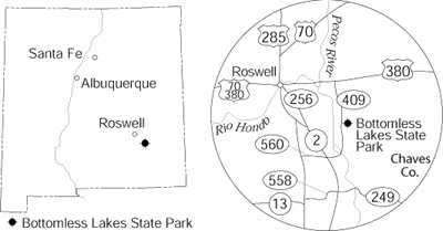
Bottomless Lakes State Park is located 14 mi southeast of Roswell, on the east edge of the Pecos River valley (Fig. 1). The park is 4 mi long, and the loop drive is 9 mi long. The park consists of approximately 1,611 acres and includes eight of nine lakes; the Fin and Feather Club owns Dimmitt Lake, the southernmost lake. Vaqueros (cowboys) who could not find the bottom of the lakes reportedly gave them their name (Young, 1984). They would tie two or three ropes together and drop them into the lakes to try to reach the bottom. The ropes were not long enough, so the vaqueros thought the lakes were bottomless! The greenish-blue color created by algae and other aquatic plants also added to the illusion of great depth.
Other tall tales and folklore abound. One tells of a horse that fell into one of the Figure Eight lakes, drowned, and was pulled out of the other. Numerous objects reportedly have been lost in the lakes, only to be retrieved later from Carlsbad Caverns or even the Gulf of Mexico. How about the stories of strong underground currents that suck divers and swimmers deep into the bowels of the Earth, never to be seen again! And of course every lake has its monster; the Bottomless Lakes monsters are fictitious giant turtles that lurk in the deep, murky waters!
Lazy Lagoon (also No Name or Intermittent Lake) is the northernmost and largest lake with a water surface area of approximately 26.1 acres. It looks deceptively shallow, but it is 70–90 ft deep in places. The white salt flats surrounding the lake actually are thin crusts of gypsum covering thick deposits of bad-smelling alkaline mud. Lazy Lagoon is formed by three sinkholes that are 90, 42, and 46 ft deep. In the summer, much of the lake evaporites except for the sinkholes. Lazy Lagoon lies along an abandoned channel of the Pecos River (Allen and Kottlowski, 1981).
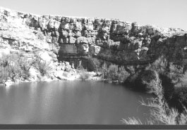
The Visitor Center lies in front of Cottonwood Lake, south of Lazy Lagoon. Cottonwood Lake is 30 ft deep and has a surface area of 0.52 acre (Fig. 2 ). It was named for a large cottonwood tree that once grew on the shore. Near-vertical rock walls rise above the lake’s surface, and very little vegetation grows along the sides. The lake is stocked with channel catfish and rainbow trout.
A hiking trail leads from Cottonwood Lake through Lake-in-the-Making, a sinkhole without water, to a scenic view of Mirror Lake. Mirror Lake has a surface area of 3.44 acres and a maximum depth of 50 ft. The lake is named after reflections of the surrounding red cliffs. Mirror Lake was once two ponds that were separated by a thin strip of land. The northern pond was too salty for fish, but the southern pond was not. Today the ponds form a single lake that is able to support fish. Mirror Lake was created by three sinkholes; two are 33 ft deep, and the third is 40 ft deep.
Devil's Inkwell, the smallest of the lakes, is named for its steep sides and dark waters, the result of algae and various aquatic plants growing along the bottom. It is 32 ft deep and has a surface area of 0.36 acre. Rainbow trout are stocked in the winter.
South of Devil's Inkwell lies Figure Eight Lake, which is actually two separate lakes formed by two sinkholes. At one time water covered the strip of land between the two lakes, and together they formed the shape of a figure eight. The southern lake is 0.76 acre and 22 ft deep, and the northern lake is 1.46 acres and 37 ft deep. Salt cedar trees border both lakes.
Pasture Lake lies south of Figure Eight Lake and is the shallowest of the lakes at Bottomless Lakes State Park. It is 18 ft deep and has a surface area of 0.76 acre. It is uncertain as to the origin of the name, but some say it was named because of a large flock of ducks that once lived here, making it appear as a pasture. South of Pasture Lake is Picnic Dell, another dry sinkhole.
Lost Lake is found hiding along the escarpment in between Picnic Dell and Lea Lake. It is small (less than 1 acre) and accessible only by hiking.
Lea Lake is the most popular lake and the only lake where swimming is allowed. Most of the developed facilities are at Lea Lake. It was named after Captain Joseph C. Lea, a rancher, veteran of the Civil War, and early settler of Roswell. Lea rode with Clark Quantrill and Frank and Jesse James during the Civil War and was a friend of William Bonney, alias Billy the Kid. Three sinkholes, 40, 60, and 90 ft deep, form the lake. A mesa overlook provides a bird's eye view of the park.
Rare and endangered species are found in the park. The small Pecos pupfish and rainwater killifish live in the lakes. The eastern barking frog and the cricket frog, also endangered species, live in the park. Their croaking can be heard throughout the day. Other animals include deer, skunk, snakes, lizards, jackrabbits, and birds.
Geology
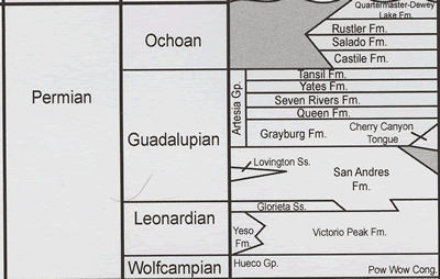
Bottomless Lakes State Park lies along the eastern bluffs of the Pecos River valley. Two major geologic units are exposed at Bottomless Lakes State Park, Quaternary river and alluvial deposits and rocks of the Permian Artesia Group, which is about 230 million yrs old (Fig. 3; Kelley, 1971; Kottlowski, 1979). Before deposition of the Artesia Group, carbonates and evaporites were being deposited by the marine seas in the Delaware Basin, which occupied much of southeastern New Mexico, in part forming the underlying San Andres Formation. The Roswell area lies on the thinner northwestern edge or shelf of the Delaware Basin. The San Andres Formation consists of interbedded limestones, dolomite, gypsum, and minor sandstone and siltstone; these rocks are not exposed in the park.
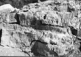
As the Delaware Basin subsided, the shelf region of the basin became more saline, and the Artesia Group was deposited. The Artesia Group consists of five formations: Grayburg (oldest), Queen, Seven Rivers, Yates, and Tansill Formations (Figure 3). These rocks consist of alternating layers of red to green to gray to white gypsum, limestone, sandstone, siltstone, and shale (Figs. 2,4,5). Later the beds were tilted gently 2°–3° to the east. Some of these beds host oil and gas deeper in the Delaware Basin to the southeast.
Petroleum is generated from source rocks rich in organic material and then migrates into reservoir rocks where it is trapped. Petroleum is less dense than the water residing in the pore spaces of the reservoir rocks and tends to migrate updip until it is trapped by an impermeable shale, sandstone, limestone, or sealing faults. Petroleum can also accumulate at the top of anticlines or in stratigraphic traps resulting from changes from one type of rock deposit to another. These structural and stratigraphic traps are common in southeastern New Mexico.
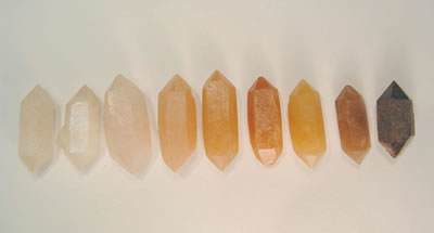
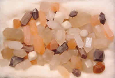
The Artesia Group is also known for "Pecos diamonds," small, doubly terminated quartz crystals found in the gypsum outcrops of the Seven Rivers Formation (Tarr, 1929; Tarr and Lonsdale, 1929; Kottlowski, 1979; Albright and Lueth, 2003). These unusual crystals range in size from microscopic to 6.5 cm in length; the average length is 2.5 cm (Albright and Lueth, 2003). The crystals vary from transparent to translucent, and the translucent crystals are white to red to yellow to nearly black (Figure 6). The crystals are found in the vicinity of the Pecos River; the northernmost locality is at Overton Ranch near the community of Dunlap in De Baca County and the southernmost locality is near Artesia, a north-south distance of about 110 miles (Albright and Lueth, 2003). These crystals are most likely formed by low-temperature solutions that permeated the gypsum beds and replaced the gypsum with the silica in the fluids. The morphology of the crystals from simple prismatic to rhombohedral shapes is consistent with a replacement origin. Most of the crystals have incompletely developed faces that also indicate a replacement origin (Tarr, 1929). Well-formed dolomite crystals also grew in the Seven Rivers Formation. A display of "Pecos diamonds" is exhibited at the Visitor Center.
Originally the Pecos River flowed west of Roswell, but the tilting of the Permian beds forced the river to shift eastward as downcutting continued. The river continued to change course to occupy the lowest point in the valley. The Quaternary river deposits consist mostly of clay and silt with minor sand and gravel. The present river channel occupies the lowest point in the valley and is bordered by floodplains of oxbow lakes and swamps that formed as a result of abandonment of the older Pecos River.
Above the Pecos River, several terraces of older sand and silt remain (Kottlowski, 1979). The upper Orchard Terrace is approximately 40 ft above the river, and the lower Lakewood Terrace is approximately 20 ft above the river. Floods that resulted from melting of glaciers in the Sangre de Cristo Mountains formed these features during the Pleistocene Ice Age, 10,000–20,000 yrs ago.
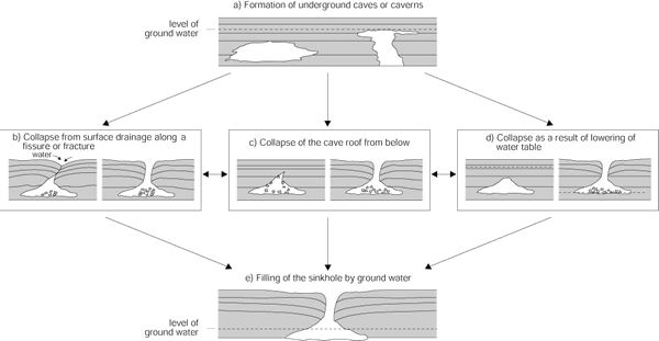
The Bottomless Lakes are actually cenotes, small perennial lakes within deep, steep-walled sinkholes that extend below the water table (Caran, 1988; Ford and Williams, 1989). The formation of cenotes begins with the dissolution of carbonates and evaporites by underground water forming underground caves. Hydrogen sulfide gas, a byproduct of oil migration, may also produce sulfuric acid that enhances the formation of underground caves and caverns. One or a combination of three processes then forms the cenotes (Fig. 6; Ford and Williams, 1989). Dissolution from above a cave, such as water percolating down a fissure, will weaken the roof of the cave and cause collapse or stoping of the roof along the fissure or other zones of weakness. Cenotes are also formed by collapse of the cave roof from below by excessive weight that widens as the collapse progressively migrates upward. The third process involves the removal of the cave roof by lowering the water table, causing an increase in the effective weight of the roof, which then collapses under its own weight.
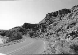
At Bottomless Lakes, water flowing through the San Andres Formation, predominantly from the Sacramento Mountains to the west (Land, 2006), slowly dissolves gypsum, halite, and limestone forming underground caves and caverns that result in collapse of the overlying rocks from their own weight. A combination of all three processes of solution, collapse, and water-table fluctuations forms the sinkholes (Fig. 7). Lakes form when the sinkholes extend below the water table. The sinkholes at Lazy Lagoon probably formed by fluctuations in the water level. Lake-in-the-Making is a sinkhole that has not yet reached the water table. This process is seen at Lea and Cottonwood Lakes where steeply dipping or sagging beds are observed in the bluffs above the lake (Fig. 2). The regional dip of the beds in this area is to the east, and the southwestward slumping of the beds above Lea Lake is a result of underground dissolution and subsidence. Folds seen elsewhere along the bluffs overlooking the park are probably a result of dissolution of underlying rocks and only partial collapse at the surface (Fig. 4 ). Any fissures or fractures that form in the overlying rocks will tend to channel surface drainage and increase the underlying collapse.
At Bottomless Lakes, evaporation rates far exceed the precipitation rates because of the present semi-arid climate. Therefore, Bottomless Lakes are actually fed by the upward movement of ground water, not downward surface drainage, as many of the legends would imply. Subsequent irrigation in the Pecos Valley has resulted in lowering of the water levels such that water no longer spills over the lake shores as it did in the early 1900s. Local fluctuations in the lake levels are also a result of seasonal changes in precipitation and available ground water. Gradual subsidence and local catastrophic collapse can still occur (Caran, 1988). Rockfalls along the bluffs and cliffs surrounding the lakes are common, so take care in hiking near the steep walls. Hiking is not allowed along the rim of these bluffs because of the potential for rockfalls.
Much of the soil present along the lake edges at Bottomless Lakes State Park is white and salty. The salts are formed by the upward migration of underground water containing gypsum and salt that precipitates when the water evaporates. Locally, a white crust is formed over deep, seemingly bottomless alkaline mud. Vehicles that travel off maintained roads could become stuck.
References
- Adams, J. E., 1965, Stratigraphic-tectonic development of Delaware Basin: American Association of Petroleum Geologists, Bulletin, v. 49, pp. 2140–2148.
- Albright, J.L., and Lueth, V.W., 2003, Pecos diamonds-quartz and dolomite crystals from the Seven Rivers Formation outcrops of southeastern New Mexico: New Mexico Geology, v. 25, p. 63-74.
- Allen, J. E., and Kottlowski, F. E., 1981, Roswell–Ruidoso–Valley of Fires: New Mexico Bureau of Mines and Mineral Resources, Scenic Trip 3, 96 pp.
- Caran, S., 1988, Bottomless Lakes, New Mexico—A model for the origin and development of ground water lakes (abs.): Geological Society of America, Abstracts with Programs, v. 20, no. 2, p. 93.
- DeFord, R. K., and Wahlstrom, E. A., 1932, Hobbs field, Lea County, New Mexico: American Association of Petroleum Geologists, Bulletin, v. 16, pp. 51– 90.
- Ford, D. C., and Williams, P. W., 1989, Karst geomorphology and hydrology: Unwin Hyman, London, 601 pp.
- Hills, J. M., 1984, Sedimentation, tectonism, and hydrocarbon generation in Delaware Basin, west Texas and southeastern New Mexico: American Association of Petroleum Geologists, Bulletin, v. 68, pp. 250–267.
- Julyan, R., 1996, The place names of New Mexico: University of New Mexico Press, Albuquerque, 385 pp.
- Kelley, V. C., 1971, Geology of the Pecos country, southeastern New Mexico: New Mexico Bureau of Mines and Mineral Resources, Memoir 24, 78 pp.
- Kottlowski, F. E., 1979, Bottomless Lakes: New Mexico Geology, v. 1, pp. 57-58.
- Land, L., 2006, Hydrogeology of Bottomless Lakes State Park: New Mexico Geological Society Guidebook 57, p. 95-96.
- Tarr, W. A., 1929, Doubly terminated quartz crystals occurring in gypsum: American Mineralogist, v. 14, pp. 19–25.
- Tarr, W. A., and Lonsdale, J. T., 1929, Pseudo-cubic quartz crystals from Artesia, New Mexico: American Mineralogist, v. 14, pp. 50–53.
- Ward, R. F., Kendall, C. G. St. C., and Harris, P. M., 1986, Upper Permian (Guadalupian) facies and their association with hydrocarbons—Permian Basin, west Texas and New Mexico: American Association of Petroleum Geologists, Bulletin, v. 70, pp. 239–262.
- Young, J. V., 1984, The state parks of New Mexico: University of New Mexico Press, Albuquerque, 160 pp.
- Zeigler, K.E., 2006, Stratigraphic chart: New Mexico Geological Society Guidebook 57, inside back cover.