


Smokey Bear Historical Park
We are a research and service division of:
modified from McLemore, V.T., 1996, Smokey Bear State Park: New Mexico Geology, v. 18, p. 104-107.
Location
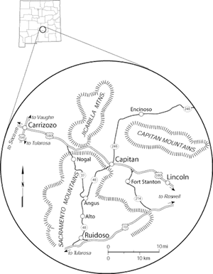
Smokey Bear Historical Park is in the center of the town of Capitan (Fig. 1), which was founded as Gray, New Mexico, in 1884 when Seaborn T. Gray homesteaded and built a small store. A post office was established in 1894. The El Paso and Northeastern (EP&NE) Railroad built a spur into Gray from Carrizozo in 1899 to obtain coal for the railroad and changed the name to Capitan after the surrounding mountains (Pearce, 1965). Capitan was a stop on the EP&NE Railroad for coal until 1905 when the railroad into the Dawson coal field in northeastern New Mexico was completed and the Carrizozo to Capitan spur was abandoned. The town was incorporated in 1941. In 1950 the townspeople took pride in being the birthplace of Smokey Bear and erected signs at each end of town on US–380 proclaiming it the home of Smokey Bear. The city museum, now next to the state one, was built of logs in the early 1950s. The Forest Service gave special permission to the town to build the Smokey Bear Motel and Cafe, which is still in operation and must, by law, advertise fire-prevention messages. A Presidential award, the Smokey Oscar, was awarded to the townspeople of Capitan in 1958 for their conservation efforts.
History
In May 1950, a raging forest fire blackened approximately 17,000 acres of the Capitan Mountains in the Lincoln National Forest in central New Mexico (Fig. 1). As forest fire fighters brought the blaze under control, a small black bear cub was found clinging to the remains of a charred tree. First aid was administered to the badly burned bear cub and he was sent to Santa Fe for further treatment. Although the fire fighters didn’t realize it then, a national symbol had been born. The story of the bear cub was told in newspapers and on radio throughout the country. The cub, named Smokey Bear, went to the National Zoo in Washington, D. C. and became the living symbol for fire prevention. Through many successful campaigns, Smokey not only was responsible for reducing the number of man-made forest fires but he also raised more than $27 billion through donations in the past 40 years (Young, 1984).
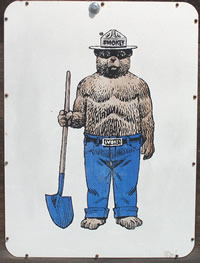
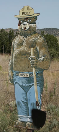
Actually, the idea of a Smokey Bear representing the national symbol for forest fire prevention originated in 1944 when Japanese fire balloons coming in from the Pacific endangered the forests on the West Coast (Young, 1984; Morrison, 1989). Most of the nation’s forest fire fighters had gone off to war, and the Japanese fire balloons emphasized the need to do something to prevent forest fires across the nation. The War Advertising Committee was formed who created Smokey Bear as a picture of a bear wearing a ranger’s uniform and carrying a shovel, saying “Remember—only YOU can prevent forest fires.” His hat was patterned after the hat of the Boy Scouts of America. Smokey was named after “Smokey Joe” Martin, the Assistant Chief of the New York City Fire Department from 1919 to 1930 (Young, 1984). The advertising campaign worked, and when the bear cub was found in the Capitan Mountains, the victim of a forest fire, it was only natural to name him Smokey and continue the fire-prevention campaign.
Smokey Bear is a national hero; he has appeared in numerous parades, in cartoons, on television, and on fire-prevention posters throughout America. Other countries have adopted the idea of a bear to symbolize fire prevention (Young, 1984). Smokey receives so much mail that he has his own zip code (20252) and each letter is answered and signed with a pawprint. The Smokey Bear Act of 1952 protects Smokey Bear and provides that only the USDA Forest Service can license Smokey Bear products (Morrison, 1989). A portion of the sale of these products goes for fire-prevention programs. A commemorative stamp was issued on August 13, 1984 at Capitan commemorating Smokey Bear (Morrison, 1989).
After Smokey died on November 9, 1976 from natural causes, his body was returned to Capitan, New Mexico where he is buried at the Smokey Bear Historical State Park (Fig. 1). A new bear cub, also the victim of a forest fire in the Capitan Mountains, was moved to the National Zoo to carry on as Smokey II.
Geology
Capitan rests in the Capitan Valley, a west-plunging syncline related to the Sierra Blanca basin. The rocks in the Capitan area are younger to the west as one travels from Hondo and Lincoln westward toward Carrizozo (Fig. 2). The oldest unit in the vicinity of Capitan is the Morrison Formation of Jurassic age found in the roadcut of NM–380 east of Capitan (Lucas, 1991). The roadcut consists of approximately 64 ft of variegated grayish-green, gray, and reddish-purple siltstones, shales, and green to yellowish-green limestones. These rocks were most likely deposited in a shallow marine sea at the extreme southern edge of the Morrison depositional basin, located in the Colorado Plateau region (Lucas, 1991). This is the southernmost exposure of the Morrison Formation in New Mexico.
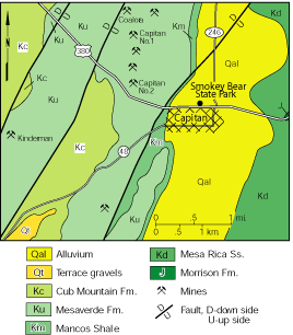
The Mesa Rica Sandstone of the Dakota Group (Lower Cretaceous) overlies the Morrison Formation at this roadcut (Lucas, 1991). This unit consists of a massive, dark-yellow to orange, crossbedded quartzarenite as thick as 150 ft that was deposited in streams and beaches along the margin of the Cretaceous sea.
The Mancos Shale (Upper Cretaceous) overlies the Mesa Rica Sandstone and makes up most of the valley surrounding Capitan. This unit consists of gray to black fissile shale with thin interbeds of gray massive limestone and thin massive beds of quartz sandstone near the top (Bodine, 1956). Although outcrops are rare, the Mancos Shale forms much of the Capitan Valley and the lower slopes of the surrounding mesas. Ammonites and bivalves are found in the shale along Salado Creek, east of Capitan, and indicate marine to brackish-water environments during Coniacian time, 88.5–87.5 million years ago (Cobban, 1986). The Mancos Shale represents one of many transgressions of marine seas during Late Cretaceous time.
Overlying the Mancos Shale is the Mesaverde Formation, which consists of a lower sandstone (150 ft thick), a middle shale and coal (150–200 ft thick), and an upper sandstone (100–150 ft thick) unit (Bodine, 1956; Kelley, 1971). The upper and lower sandstones are massive to medium bedded, white to buff and fine to medium grained (Kelley, 1971). The shale is light gray to black with thin interbeds of siltstone, sandstone, and coal. The lower sandstone represents retreat of the Mancos sea, followed by another minor transgression which deposited the middle shale. The coal was probably deposited in back-barrier or lower delta-plain environments along the coast adjacent to the Cretaceous sea. The sea once again retreated, as represented by the coal and overlying upper sandstone.
In 1884, coal was discovered east of Capitan (Fig. 2) and became known as the Capitan or Salado coal field (Slagle, 1991). Coal was produced in 1885 by Seaborn T. Gray, original settler of Capitan. The bituminous coal beds range from 2.5 to 5.5 ft thick. At least 20 mines were opened in the Mancos Shale, and total production from 1895 to 1939 amounted to 714,869 tons (Gretchen Hoffman, oral comm. July 1995). Coal was used by the railroad until 1905 when the Carrizozo to Capitan spur was abandoned. After 1905, coal was mined for local use. Future resource potential is low because of variable thickness of the beds, excessive faulting, intrusion by Tertiary dikes, and low tonnage (Bodine, 1956).
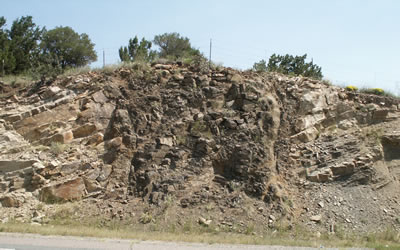
Tertiary dikes and sills related to the Sierra Blanca igneous complex and Lincoln County porphyry belt cut the Cretaceous rocks in roadcuts just west of Capitan (Figs. 3 and 4). These igneous rocks are 26 to 38 million years old (Allen and McLemore, 1991)
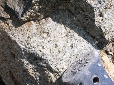
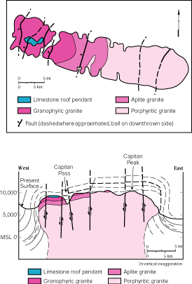
The Capitan Mountains, the birthplace of Smokey Bear, form the skyline behind Smokey Bear Historical State Park and represent the largest Tertiary intrusive pluton in New Mexico (McLemore and Phillips, 1991; Allen and McLemore, 1991). The pluton consists of texturally and chemically zoned alkali-feldspar granite (Fig. 5). The textural zones are not easily recognized in outcrop, but can be distinguished by looking at thin sections of the rock through a special, high-power microscope. The roof of the pluton (west end) consists of high-silica micromiarolitic, granophyric granite. Micromiarolites are small cavities in the granite that are commonly filled with very tiny crystals (typically less than 1 mm) of fluorite, titanite, feldspar, quartz, and other minerals. A granophyric texture refers to a specific microscopic texture formed by the intergrowth of quartz and alkali-feldspar that resembles zebra stripes. This granite is gradational with the transitional or central zone of aplite granite, which refers to the fine-grained texture. The core of the pluton, also gradational with the transitional zone, consists of porphyritic granite, which refers to the specific texture formed by large phenocrysts of plagioclase feldspars surrounded by a fine-grained matrix. The pluton intrudes Paleozoic limestone and has been dated as 28.3 ± 0.1 Ma by 40Ar/39Ar on feldspar (Campbell et al., 1994). Outcrops of Paleozoic limestone form roof pendants on top of the Tertiary Capitan pluton (Fig. 5).
The eastern Capitan Mountains are known for contact-metasomatic replacement iron deposits, which are genetically related to the pluton. The Smokey iron mine (Fig. 2) has operated sporadically since 1921 (Smith, 1991). The deposit consists of pods and irregular veins of magnetite, hematite, and other iron oxides replacing limestones of the San Andres Formation of middle to late Permian age (approximately 268–245 million years old). The deposits are 100 ft thick and 1,300 ft in diameter and are surrounded by a zone of calc-silicate minerals (garnet, epidote, phlogopite, and tremolite). Minor veins of manganese, fluorite with quartz, rare-earth elements, and uranium also are found in the Capitan Mountains, but only minor amounts of manganese and uranium have been produced (McLemore and Phillips, 1991).
Some of the upper steep slopes of the Capitan Mountains are covered by rock talus or debris deposits, called rock glaciers. These rock glaciers consist of cobbles and boulders of the Capitan alkali-feldspar granite and were formed by ice glaciers during the Late Pleistocene, approximately 128,000 to 71,000 years ago (Blagbrough, 1991, 1994).
References
- Allen, M. S., and McLemore, V. T., 1991, The geology and petrogenesis of the Capitan pluton, New Mexico; in Barker, J. M., Kues, B. S, Austin, G. S., and Lucas, S. G. (eds.), Geology of the Sierra Blanca, Sacramento, and Capitan Ranges, New Mexico: New Mexico Geological Society, Socorro, Guidebook 42, pp. 115–127.
- Blagbrough, J. W., 1991, Late Pleistocene rock glaciers in the western part of the Capitan Mountains, Lincoln County, New Mexico: description, age, and climatic significance; in Barker, J. M., Kues, B. S, Austin, G. S., and Lucas, S. G. (eds.), Geology of the Sierra Blanca, Sacramento, and Capitan Ranges, New Mexico: New Mexico Geological Society, Socorro, Guidebook 42, pp. 333–338.
- Blagbrough, J. W., 1994, Late Wisconsin climatic inferences from rock glaciers in south-central and west-central New Mexico and east-central Arizona: New Mexico Geology, v. 16, no. 4, pp. 65–71.
- Bodine, M. W., Jr., 1956, Geology of the Capitan coal field, Lincoln County, New Mexico: New Mexico Bureau of Mines and Mineral Resources, Circular 35, 27 pp.
- Campbell, A. R., Heizler, M. T., and Dunbar, N. W., 1994, 40Ar/39Ar dating of fluid inclusions in quartz from the Capitan pluton, New Mexico (abs.): Fifth Biennial Pan-American Conference on Research on Fluid Inclusions, Abstracts, p. 11.
- Cobban, W. A., 1986, Upper Cretaceous molluscan record from Lincoln County, New Mexico; in Southeast Section of AAPG, Transactions and Guidebook of 1986 convention: New Mexico Bureau of Mines and Mineral Resources, pp. 77–89.
- Kelley, V. C., 1971, Geology of the Pecos country, southeastern New Mexico: New Mexico Bureau of Mines and Mineral Resources, Memoir 24, 78 pp.
- Lucas, S. G., 1991, Southeasternmost outcrops of the Morrison Formation, Capitan, Lincoln County, New Mexico; in Barker, J. M., Kues, B. S, Austin, G. S., and Lucas, S. G. (eds.), Geology of the Sierra Blanca, Sacramento, and Capitan Ranges, New Mexico: New Mexico Geological Society, Socorro, Guidebook 42, p. 41.
- McLemore, V. T., and Phillips, R. S., 1991, Geology of mineralization and associated alteration in the Capitan Mountains, Lincoln County, New Mexico; in Barker, J. M., Kues, B. S, Austin, G. S., and Lucas, S. G. (eds.), Geology of the Sierra Blanca, Sacramento, and Capitan Ranges, New Mexico: New Mexico Geological Society, Guidebook 42, pp. 291–298.
- Morrison, E. E., 1989, Guardian of the forest: a history of the Smokey Bear program: 2nd edition, Moralle Press, Alexandria, Virginia, 132 pp.
- Pearce, T. M., 1965, New Mexico place names: University of New Mexico Press, Albuquerque, 187 pp.
- Slagle, E. S., 1991, History of coal mining in the Sierra Blanca coal field, Lincoln and Otero Counties, New Mexico; in Barker, J. M., Kues, B. S, Austin, G. S., and Lucas, S. G. (eds.), Geology of the Sierra Blanca, Sacramento, and Capitan Ranges, New Mexico: New Mexico Geological Society, Guidebook 42, pp. 54–57.
- Smith, C. T., 1991, Notes on the Smokey mine, Capitan iron deposits, Lincoln County, New Mexico; in Barker, J. M., Kues, B. S, Austin, G. S., and Lucas, S. G. (eds.), Geology of the Sierra Blanca, Sacramento, and Capitan Ranges, New Mexico: New Mexico Geological Society, Guidebook 42, pp. 42–44.
- Young, J. V., 1984, The State Parks of New Mexico: University of New Mexico Press, Albuquerque, 160 pp.