


Overview of Fresh and Brackish Water Quality - Palomas Basin
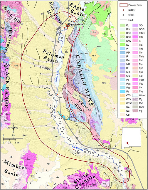
The Palomas Basin is an east-tilted half graben ~35 miles long by 12 miles wide, bordered to the east by the Caballo Mountains and Red Hills, and to the west by the Black Range, Animas Hills, Salado Hills, and southern Sierra Cuchillo. The north end of the Palomas Basin is defined by the Mud Springs Mountains and several faults that intersect near Truth or Consequences, which separate the Palomas Basin from the Engle Basin to the north. The basin merges to the south with the eastern Mimbres Basin (Chapin, 1971). The Palomas Basin contains up to 6,500 feet of Tertiary alluvial fan and lacustrine sediments of the Santa Fe Group along its deep eastern margin, overlain by ~500 feet of alluvial fan and axial-fluvial sediments of the Plio-Pleistocene Palomas Formation (Mack, 2012).
Groundwater recharge occurs along the western edge of the Palomas Basin, through alluvial fans at the edge of the Animas Hills, and flows east toward the Rio Grande and Caballo Lake. A north to south regional groundwater flow system is also present, representing flow-through drainage through alluvial sediments of the Rio Grande Rift (Jones et al., 2014). Principal water-bearing units are alluvial fan deposits and fluvial sands and gravels of the Santa Fe Group, and Quaternary alluvium of the inner Rio Grande valley and its principal tributaries (Hawley and Kennedy, 2004). Stratification and heterogeneity of the Santa Fe Group has created confined conditions at depth in the lower Palomas Basin, resulting in artesian conditions in the basin down-gradient from recharge zones (Jones et al., 2014). Upwelling of mineralized geothermal waters also occurs in the vicinity of Truth or Consequences at the faulted north end of the basin, originating from Precambrian crystalline basement rocks that discharge into the overlying alluvium (Person et al., 2013).
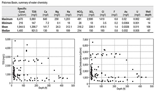
Our rather limited data set (203 total data points) indicates that water resources in the Palomas Basin have a relatively high mineral content, with mean TDS of almost 1,300 mg/l and mean chloride concentrations >400 mg/l. Plots of depth vs. TDS and specific conductance show a bimodal distribution of dissolved solids. Slightly less than half the wells sampled show dissolved solids below 1,000 mg/l. However, a significant population of data points exceed 2,000 mg/l, at depths ranging from 14 to 292 feet. This bimodal distribution reflects in part samples that were collected from the Truth or Consequences hot springs resort district, although slightly to moderately brackish water was also sampled farther south, near Hatch. This sampling bias is also reflected in arsenic concentrations, which show a basin-wide mean of just 0.0028 mg/l. However, a maximum arsenic concentration of 0.02 mg/l, or 20 ppb, was measured in a well in Truth or Consequences, reflecting upwelling of highly mineralized geothermal water in that area.
Saline water resources are apparently present at depth in the northern Palomas Basin, probably originating in deep Precambrian basement rocks, and mixing with groundwater in Paleozoic carbonate aquifers, and are currently being exploited by hot springs resorts in Truth or Consequences. Recent investigations (Person et al., 2013) indicate that the volume and sustainability of this geothermal resource is not well-understood.
This project is funded by the New Mexico Environment Department, Drinking Water Bureau, under Source Water Protection.
For more information:
see: Overview of Regional Brackish Water Assessments
or contact:
Lewis Land — Hydrogeologist, lland@nckri.org
References
- Land, Lewis, 2016, Overview of Fresh and Brackish Water Quality in New Mexico - Palomas Basin, Project Summary Sheet.
- Land, Lewis, 2016, Overview of Fresh and Brackish Water Quality in New Mexico, New Mexico Bureau of Geology Mineral Resources, Open-file Report, v. 0583, pp. 55.