


Tsiping
We are a research and service division of:
Introduction

Tsiping, also called Tsi’pin or Tsi’pinouinge, is a remarkable pueblo ruin located on Pueblo Mesa near the village of Cañones in the northern Jemez Mountains. Although the site is on Santa Fe National Forest land, the site is off limits unless you have a permit. Permits can be obtained from the Coyote Ranger Station.
Tsi’pinouinge means “village of the flaking stone”, a reference to the village’s proximity to lithic-source quarries in the Pedernal Chert on Cerro Pedernal. Based on tree-ring measurements and ceramic styles, Tsiping was occupied between 1200 AD and 1325 AD, during the Classic Period. Tsiping was the northernmost and largest of the Classic Period pueblos. The village had somewhere between 335 to 400 ground floor rooms, sixteen kivas, and a central plaza. Cavate dwellings are located on the southeastern side of the mesa.
Location
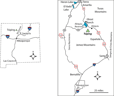
Take County Road 189 (Forest Road 31) south from the village of Abiquiu (Figure 1). The first 1.1 miles of the road are paved, but the rest of the journey will be on reasonably good dirt roads. After traveling 6.4 miles south on Forest Road 31, you will reach an intersection with Forest Road 27. Turn right on Forest Road 27 and drive 8.1 miles to Forest Road 27D, a two track road to the right. Drive along 27D for 1.2 miles to a parking lot on the north end of Polvadera Mesa. A trail leads from the west end of the parking lot to the ruins on Pueblo Mesa. The elevation drop on the trail is about 500 feet, and the trail is approximately 2 miles long.
While it is tempting to gain access to Tsiping via the village of Cañones, it is not advisable to do so. The residents of Cañones value their privacy; please respect their wishes.
Regional Geologic Setting
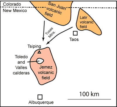
Tsiping is in the northern Jemez Mountains, which were formed by a volcanic field that was active ~16 million to ~50,000 years ago. This area lies near the boundary of two major physiographic provinces, the Colorado Plateau, and the Rio Grande rift (Figure 3). The Cañones fault zone, a major northeast-striking structure along the boundary, is located just to the west of Pueblo Mesa.
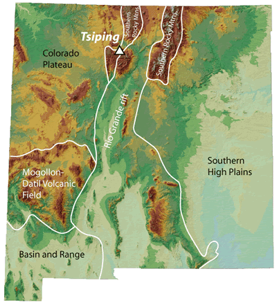 Figure 3. Physiographic setting of Tsiping.
Stratigraphy and Geologic History
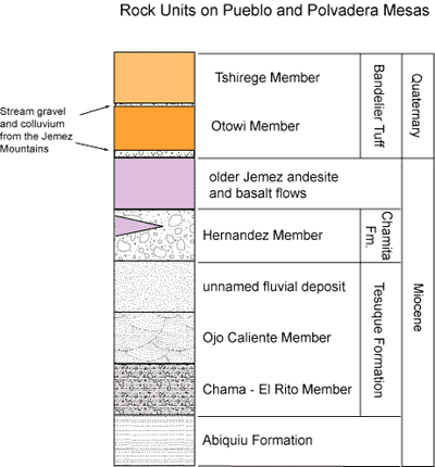
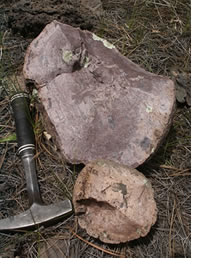
The ruins of Tsiping are sited on a mesa that preserves a remarkable geologic history (Figure 4). The oldest unit at the base of the north end of the mesa is composed of well-cemented, tabular-bedded, white to tan sandstone of the Abiquiu Formation. This 27-to-18 million-year-old sandstone was deposited by sediment-choked southwest-flowing streams. The Abiquiu Formation contains distinctive clasts of Amalia Tuff (Figure 5) and dacitic pumice derived from the Latir volcanic field north of Taos (Figure 6). The Abiquiu Formation grades up into reddish tabular-to-cross-bedded sandstone and mudstone laid down by a south-flowing river. This reddish unit is called the Chama–El Rito Member of the Tesuque Formation. The clasts in the Chama–El Rito Member include Amalia Tuff, as well as volcanic pebbles derived from the San Juan volcanic field in Colorado (Figure 6). The river deposits are overlain by a sandstone with large-scale cross-beds that generally dip toward the northeast. Wind blowing from the southwest toward the northeast deposited this sandstone, which is called the Ojo Caliente Sandstone. Sand dunes covered much of the area now occupied by the northern Jemez Mountains and the northwestern Española Basin. A river system was reestablished locally in the Cañones area, re-working the sand from the sand dunes. A younger, regional-scale, south-flowing river system deposited conglomerates containing clasts of volcanic rocks from the San Juan field, Proterozoic granite and quartzite from the Tusas Mountains, and occasionally Amalia Tuff from the Latir volcanic field (Figure 5). These deposits belong to the Hernandez Member of the Chamita Formation. Volcanic centers in the northern Jemez Mountains a few miles to the southwest of Pueblo Mesa were active 7-to-8 million years ago, at the same time that the Hernandez river system was flowing through the area. The andesite and basalt on Polvadera Mesa is interbedded with the Hernandez Member.
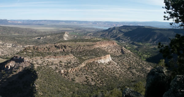
After a period of faulting and erosion, the ~3 million year old dacite, andesite, and basalt flows that form Cañones Mesa to the east of Pueblo Mesa were erupted. Erosion in the area began again and a north-flowing stream valley formed under what is now Tsiping. The violent volcanic eruption that led to the formation of the Toledo caldera a few miles to the south (Figure 5) 1.6 million years ago sent hot, roiling Otowi Member tuff down the valley, clogging the drainage. An episode of erosion led to the reestablishment of the valley, leaving a sharp pinnacle of Otowi Member of the Bandelier Tuff and a deep gash cut into the tuff. A second violent eruption formed the Valles caldera to the south 1.25 million years ago, and hot ignimbrite once again came swirling down the valley, surrounding the Otowi Member pinnacle and filling in the low spots around the paleohigh (Figures 1 and 7). More recent erosion has formed valleys on either side of Tsiping, leaving the former valley as a mesa, and creating a striking example of inverted topography (Figure 1 and 8).
What You Can See Along the Trail
The trailhead on Polvadera Mesa is on ~7.8 million year old andesite that was erupted from a vent a few miles to the southwest in the Jemez Mountains. The trail starts down the side of the mesa toward the east, switches back to the west, then turns back toward the east again. If you look up through the trees at this second switchback, you can see the base of one of the andesite flows. If you look carefully at the rocks in the trail, you will notice rounded volcanic pebbles weathering out of the Hernandez Member of the Chamita Formation.
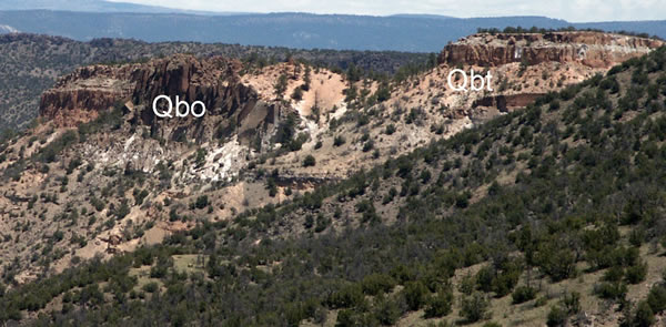
The trail descends to a narrow ridge that is formed by the localized sandy fluvial deposit in the Tesuque Formation. The trail continues north across the ridge to Pueblo Mesa, which is capped by white to orange-tan tuff. The main pueblo ruin is on the Otowi Member of the Bandelier Tuff, which is distinctive because the tuff contains abundant chocolate-brown rock fragments.
References
- Kelley, S.A., Osburn, G.R., Lawrence, J.R., Ferguson, C., Moore, J., Kempter, K., 2005 (updated 2007), Preliminary geologic map of the Cañones 7.5-minute quadrangle, Rio Arriba County, New Mexico, New Mexico Bureau of Geology and Mineral Resources, Open-file Geologic Map OF-GM 107, scale 1:24,000.
- Koning, D.J., Kelley, S.A., and Kempter, K.A., 2007, Geologic structures near the boundary of the Abiquiu embayment and Colorado Plateau — A long history of faulting: New Mexico Geological Society Guidebook 58, p. 43-46.