


Morphy Lake State Park
We are a research and service division of:
modified from McLemore, V.T., 2002, Morphy Lake State Park: New Mexico Geology, v. 24, no. 2, p. 52-56.
Introduction
Morphy Lake State Park offers fishermen, campers, hikers, and other visitors a rustic alpine setting in the Sangre de Cristo Mountains. Spectacular views are the result of complex geologic processes active since Proterozoic time (1,700 m.y. ago): two major periods of mountain building (called orogenies) and most recently erosion and sedimentation by glaciers and rivers.
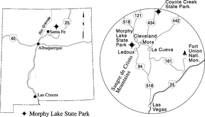
The state park is 7 miles southwest of Mora and 3 miles northwest of Ledoux in the eastern Sangre de Cristo Mountains in northern New Mexico (Fig. 1). It is the least accessible of the New Mexico state parks. From Ledoux on NM–94, the park is reached by a marked, 3-mile dirt road that can become impassable in bad weather. Four-wheel drive vehicles are recommended; trailers and low-clearance vehicles are discouraged. The park surrounds a lake that is 15–25 acres in size. An earthen dam was built in the late 1930s to enlarge the natural lake. An intake canal north of the dam feeds the lake. An outlet tower at the southeast end of the dam allows for overflow into the creek that enters Rito Morphy. The Sangre de Cristo Mountains and the Pecos Wilderness on the skyline rise to elevations in excess of 10,000 ft.
The New Mexico Department of Game and Fish stocks the lake with rainbow trout, and native German brown trout also are common. Ice fishing is popular in winter. Ducks and geese can be found on the lake, and many other birds, including ravens, crows, blackbirds, and jays, frequent the state park. Squirrels, raccoons, porcupines, coyotes, deer, and black bear also wander through. Wildflowers dot the landscape after a rain.
Geology
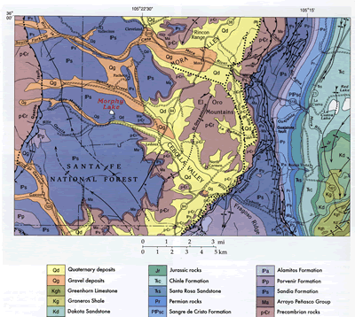
The mountain forming the western skyline is Cebolla Peak (elevation 11,879 ft) of the Sangre de Cristo Mountains. Most of the mountain range is composed of Proterozoic rocks of the Vadito and Hondo Groups, which consist of as much as 20,800 ft of mixed sedimentary and volcanic rocks that were subsequently metamorphosed (Fig. 2; Montgomery, 1963; Baltz and Meyers, 1999; Read et al., 1999; Williams et al., 1999). The Hondo Group, dominated by the Ortega Quartzite, is younger than the 1,720–1,700 m.y. old Vadito Group that is exposed near Coyote Creek State Park approximately 20 miles to the northeast (Williams, 1990; McLemore, 1999). Deformation and metamorphism of the rocks probably occurred during several episodes between 1,650 and 1,400 m.y. ago (Williams et al., 1999). These metamorphic rocks also are exposed along the dirt road from Ledoux to the state park. Eroded boulders and pebbles of multicolored white to gray to brown gneiss, schist, and quartzite from the Rincon Range to the north and the Sangre de Cristo Mountains to the west are found throughout the park. The Proterozoic rocks are similar to those forming El Oro Mountains east of Morphy Lake State Park, which consist of Proterozoic gneiss, muscovite schist, and amphibolites that are intruded by granitic pegmatites (Cepeda, 1972; Baltz and O’Neill, 1984; Baltz and Myers, 1999). The metamorphic rocks were once sedimentary and volcanic rocks that were intruded by mafic sills (amphibolites) and granitic pegmatites. At least two periods of deformation and metamorphism occurred during the Proterozoic, as evidenced by complex folds, regional doming, and shearing.
The brown arkosic sandstone and conglomerate and interbedded gray shale found at Morphy Lake State Park belong to the Pennsylvanian Sandia Formation, which was deposited about 320–315 m.y. ago in a deep marine basin called the Rowe–Mora Basin (Bachman, 1953). The Sandia Formation lies unconformably above the steeply dipping Proterozoic rocks (Baltz and O’Neill, 1984; Baltz and Myers, 1999). The sandstone consists of quartz, feldspar, rock fragments, and mica derived from older Proterozoic metamorphic rocks. The shales are brown to black and vary in thickness. Brachiopod fossils (marine shelled animals) are found in thin limestone and shale beds south of the dam. In this area, most of the sediments in the Sandia Formation were shed from the Uncompahgre uplift to the west. Both the basin and the uplift formed at the same time as the Ancestral Rocky Mountains during the Pennsylvanian Period (330–290 m.y. ago). Subsequently, shallow seas retreated and returned several times during Permian through Cretaceous (65 m.y. ago) time. Only the oldest marine rocks of Pennsylvanian age are exposed at Morphy Lake; the younger sedimentary rocks have been eroded.
The rugged topography of the Sangre de Cristo Mountains that we see today on the western skyline is the result of a series of relatively recent geologic events. Starting about 70 m.y. ago during Late Cretaceous–early Tertiary time, the region was subjected to uplifting, faulting, folding, and tilting during a mountain-building event known as the Laramide orogeny. Evidence of this orogeny is visible to the east of the park, where the Rocky Mountains meet the Great Plains along a dramatic zone of faults and folds. Major periods of erosion followed uplift, carving river valleys, forming alluvial fan and stream deposits along the eastern foothills and valleys of the Sangre de Cristo Mountains, and depositing great thicknesses of alluvium over the Great Plains to the east.
More than 10,000 yrs ago during the wetter Pleistocene climate, small mountain glaciers developed on the mountain ridge. Glaciers are formed when fallen snow, over many years, compresses into large, thickened, slowly flowing ice masses. These alpine glaciers actually moved down the mountain a short way, similar to a slow river, and formed deep, bowl-shaped, steep-walled reentrants called cirques. Glaciers slowly erode the mountain, not by the ice, which is too soft to cut rocks, but by rock fragments embedded within the ice, which are effective cutting tools. The rock-choked ice grazes over the glacier bed, removing rock obstacles and leaving the bedrock rounded and smoothed. The depressions left behind by the glaciers later filled with water and formed Pacheco, Santiago, and Enchanted Lakes in the Sangre de Cristo Mountains. These three lakes, at an elevation of approximately 10,700–10,900 ft, mark the extent of downward movement by the alpine glaciers. As the climate warmed, the glaciers melted, and streams carved the mountain below the lakes and formed Morphy Lake and Rito Morphy, which visitors cross just before entering Morphy Lake State Park. The upper reaches of Rito Morphy consist of glacial boulders and pebbles that geologists call glacial outwash, whereas the lower parts consist of deposits of coarse- to medium-grained fluvial material.
References
- Bachman, G. O., 1953, Geology of a part of northwestern Mora County, New Mexico: U.S. Geological Survey, Oil and Gas Investigations Map OM–137, 1 sheet, scale 1.25 inch to 1 mi.
- Baltz, E. H., and Myers, D. A., 1999, Stratigraphic framework of upper Paleozoic rocks, southeastern Sangre de Cristo Mountains, New Mexico, with a section on speculations and implications for regional interpretation of Ancestral Rocky Mountains paleotectonics: New Mexico Bureau of Mines and Mineral Resources, Memoir 48, 269 pp.
- Baltz, E. H., and O’Neill, J. M., 1984, Geologic map and cross sections of the Mora River area, Sangre de Cristo Mountains, Mora County, New Mexico: U.S. Geological Survey, Miscellaneous Investigations Map I–1456, scale 1:24,000.
- Cepeda, J. C., 1972, Geology of Precambrian rocks of the El Oro Mountains and vicinity, Mora County, New Mexico: Unpublished M.S. thesis, New Mexico Institute of Mining and Technology, 63 pp.
- McLemore, V. T., 1999, Coyote Creek State Park: New Mexico Geology, v. 21, no. 1, pp. 18–21.
- Montgomery, A., 1963, Precambrian rocks; in Miller, J. P., Montgomery, A., and Sutherland, P. K., Geology of part of the southern Sangre de Cristo Mountains, New Mexico: New Mexico Bureau of Mines and Mineral Resources, Memoir 11, pp. 7–21.
- Read, A. S., Karlstrom, K. E., Grambling, J. A., Bowring, S. A., Heizler, M., and Daniel, C., 1999, A middle-crustal cross section from the Rincon Range, northern New Mexico—evidence for 1.68-Ga, pluton-influenced tectonism and 1.4-Ga regional metamorphism: Rocky Mountain Geology, v. 34, pp. 67–91.
- Williams, M. L., 1990, Proterozoic geology of northern New Mexico: Recent advances and ongoing questions; in Bauer, P. W., Lucas, S. G., Mawer, C. K., and McIntosh, W. C. (eds.), Tectonic development of the southern Sangre de Cristo Mountains, New Mexico: New Mexico Geological Society, Guidebook 41, pp. 151–159.
- Williams, M. L., Karlstrom, K. E., Lanzirotti, A., Read, A. S., Bishop, J. L., Lombardi, C. E., Pedrick, J. N., and Wingsted, M. B., 1999, New Mexico middle-crustal cross sections: 1.65-Ga macroscopic geometry, 1.4-Ga thermal structure, and continued problems in understanding crustal evolution: Rocky Mountain Geology, v. 34, pp. 53–66.
- Young, J. V., 1984, The state parks of New Mexico: University of New Mexico Press, Albuquerque, 160 pp.