


Red Rock Park
We are a research and service division of:
modified and updated from:
McLemore, V.T., 1989, Red Rock State Park: New Mexico Geology, v. 11, no. 2, p. 34-37.
McLemore, V.T., 2003, Red Rock Park, New Mexico Geological Society Guidebook 54, p. 54-55.
Introduction
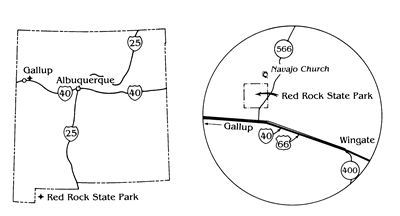
Red Rock Park takes its name from the spectacular red sandstone cliffs surrounding an impressive array of public facilities, including a rodeo arena, convention center, museum, and campgrounds. Church Rock, or Navaho Church, is a prominent landmark in the park. The 640-acre park offers excellent scenery for balloonists, hikers, campers, and other visitors. Red Rock Park opened in 1972 as a state park at a cost of $6 million (McLemore, 1989), but in 1989 the park was turned over to the Navajo Nation. The park is located 10 miles east of Gallup in McKinley County, north of I-40 via NM-566 (Figure 1).
Geology
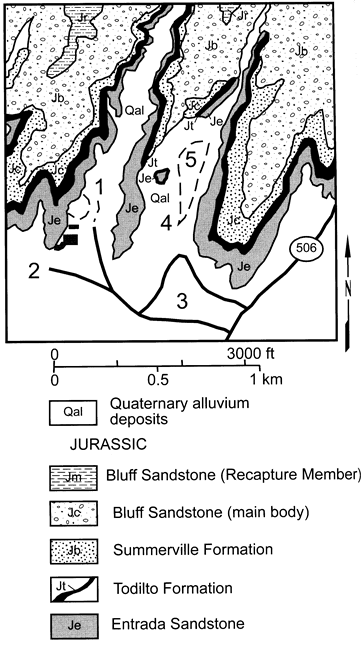
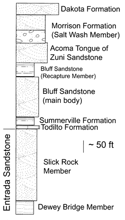
Middle to Upper Jurassic (175-145 million years old) and Quaternary ( less than 1 m.y.) rocks are exposed in Red Rock Park (Figures 2 and 3). Older rocks, the Triassic river deposits of the Chinle Group, are exposed in the plains to the south of the park and younger Cretaceous rocks form the high ridges north of the park. The spectacular massive cliffs forming background for the public facilities in the park belong mostly to the Jurassic Entrada Sandstone. The Entrada Sandstone is divided into two members, Dewey Bridge Member and overlying Slick Rock Member. The Dewey Bridge Member consists of 40-60 ft of reddish-brown, reddish-orange silty sandstone and siltstone that form slope the base of the massive cliffs. The Slick Rock Member forms the spectacular cliffs and consists of 100-400 ft of reddish-orange well-cemented, thick-bedded, well-rounded sandstones, typical of ancient sand dunes. High-angle crossbeds or layers are seen in the sandstone. The sand dunes were cemented by silica and calcite from ground water and compacted to form the massive rock cliffs seen today.
The Jurassic Todilto and Summerville formations overlie the Entrada Sandstone. The Todilto Formation is the older unit and forms a thin, white to gray, resistant cap on top of the Entrada Sandstone. It consists of as much as 10 ft of fine-grained limestone that was deposited in a saline lake. Overlying the Todilto Formation are slopes of interbedded white, pink, and reddish-brown sandstone, siltstone, and shale belonging to the Summerville Formation. The Summerville Formation is locally as much as 50 ft thick and was deposited in a shallow-water coastal plain.
The Jurassic Bluff Sandstone overlies the Summerville Formation and consists of 190 ft of green-gray to pink, well-cemented sandstone (Green and Jackson, 1975). The lower, main body, was deposited in an arid environment as sand dunes (Condors and Peterson, 1986). The overlying Recapture Member consists of 100 ft of reddish-brown to brick-red siltstone interbedded with white to green to yellow sandstone (Green and Jackson, 1975). The Recapture Member is well exposed at the base of Navajo Church, as seen from the Outlaw Trading Post. The Recapture Member was deposited in both fluvial and eolian, sand-dune environments. The overlying Acoma Tongue of the Zuni Sandstone is the prominent eolian sandstone with east-dipping crossbeds at the base of Church Rock (Anderson, 1993).
The Jurassic Morrison Formation overlies the Acoma Tongue and consists of two members: Salt Wash and overlying Brushy Basin members. The Salt Wash Member is not exposed within the park boundaries, but it is visible on some of the mesas north of the park and at the top of Navajo Church. This unit consists of 130-230 ft of red to orange sandstone with thin lenses of siltstone and shale (Green and Jackson, 1975). It was deposited in a fluvial environment and is host to most of the uranium resources in the Gallup-Grants area.
The Brushy Basin Member also is not exposed within the park boundaries but crops out north of the park (Green and Jackson, 1975). It consists of green to purple to gray shale, siltstone, and sandstone.
The Upper Cretaceous Dakota Formation on White Rock Mesa can been seen in the distance to the north of Navaho Church. The contact between the Salt Wash Member of the Morrison Formation and the Dakota Formation on White Rock Mesa represents a 50 million year gap in the sediment record (Lucas et al., 2003). The Dakota Formation consists of sandstone and interbedded shales and coal deposited in swamps and rivers adjacent to the Cretaceous seas that covered much of New Mexico approximately 95 million years ago.
The rocks around Red Rock Park were subsequently eroded, mainly by wind and rain, to form mesas and spires such as Navajo Church. Erosion of the rock continues today and contributes to Quaternary alluvium and unconsolidated wind-blown (eolian) sand and silt deposits in the park.
References
- Anderson, O.J., 1993, Zuni Sandstone and Acoma Tongue defined: New Mexico Geology, v. 15, p. 18-19.
- Condon, S. M., and Peterson, Fred, 1986, Stratigraphy of Middle and Upper Jurassic rocks of the San Juan Basin: Historical perspective, current ideas, and remaining problems; in Turner-Peterson, C. E., Santos, E. S., and Fishman, N. S. (eds.), A basin analysis case study: The Morrison Formation Grants uranium region, New Mexico: American Association of Petroleum Geologists, Studies in Geology 22, pp. 7-26.
- Green, M. W., and Jackson, T. J., 1975, Geologic map of the Church Rock quadrangle, McKinley County, New Mexico: U.S. Geological Survey, Open-file Report 75258, scale 1:24,000.
- Lucas, S.G., Heckert, A.B., Berglof, W.R., Kues, B.S., Crumpler, L.S., Aubele, J.C., McLemore, V.T., Owen, D.E., and Semken, S.C., 2003, Second-day road log from Gallup to Fort Wingate, Sixmile Canyon, Ciniza, Red Rock Park, Church Rock, White Mesa, Thoreau, and Grants, New Mexico Geological Society Guidebook 54, p. 35-68.
- McLemore, V.T., 1989, Red Rock State Park: New Mexico Geology, v. 11, no. 2, p. 34-37.