


Ute Lake State Park
We are a research and service division of:
modified from McLemore, V.T., 1997, Ute Lake: New Mexico Geology, v. 19, no. 4, p. 96-98
Introduction
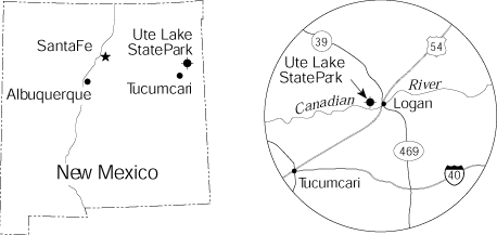
Ute Lake State Park was established in 1964 at a cost of approximately $5 million and was named after Ute Creek, one of the tributaries of the Canadian River that is impounded by a dam. The small town of Logan is on the east side of the lake (Fig. 1), and the lake extends upstream in both the Ute and Canadian Rivers. It is 25 miles northeast of Tucumcari on US–54, NM–39, and NM–540 and is approximately 20 miles west of the Texas–New Mexico state line. Most of the land surrounding Ute Lake is private. All the water is open to the public.
L. Greer Price
The original dam was built in 1963 without any Federal funds by the New Mexico Interstate Streams Commission to store water from the Canadian River and Ute Creek for use in New Mexico (Young, 1984). In 1983–84, the U.S. Bureau of Reclamation increased the capacity of Ute Lake (Fig. 2) by raising the dam and building the largest Labyrinth Weir Spillway in the United States, north of the dam. This 14-cycle spillway increased the height of the lake by 27 ft without using expensive flood gates on the existing Ogee Weir Spillway. The new Labyrinth Weir Spillway is a repetition of triangular shapes that expanded the length of the flood crest and increased the discharge capacity. Construction of the spillway required 27,000 cu yds of concrete reinforced by 7.4 million pounds of steel. It is 840 ft wide, 30 ft high, and 117 ft deep. Each of the 14 cycles has a crest length of 240 ft and is 2–5 ft thick.
Ute Dam is a zoned earth-filled dam that is 148 ft high and 2,050 ft long. Today, the lake has a reservoir capacity of 272,000 acre-ft of water and sediment. A dike 2,860 ft long extends north from the spillway. The dam discharges on the north side of the river, south of the spillway, and has a discharge capacity of 275 ft3/sec. It was the first dam in the United States to use soil-cement protection on the slopes of the dam instead of riprap (Graham, 1985).
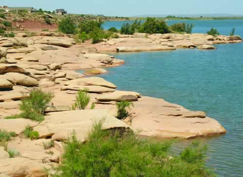
Ute Lake State Park ranges in elevation from 3,700 to 3,900 ft above sea level and occupies 1,480 acres of land and 4,078 acres of water (surface). Piñon, juniper, mesquite, and yucca cover the hillslopes and mesas surrounding the lake, and various wild flowers and cacti, including cholla and prickly pear, are common. Falcons, mountain bluebirds, quail, dove, ducks, and geese are plentiful. A few bald eagles inhabit the area as well. Antelope and deer roam the countryside.
Geology
Ute Lake State Park is in the Pecos Valley section of the Great Plains physiographic province. It lies on the north edge of the Llano Estacado or “staked plains.” This feature extends from the Pecos River on the west to Palo Duro Canyon in Texas on the east and southward to Hobbs, New Mexico, covering an area of about 32,000 mi2 (Reeves, 1972). The origin and meaning of Llano Estacado are controversial. Some claim that the name refers to natural stockades created along the rough rim of this plateau, which rises 150 ft above the adjacent plains and river valleys. Estacada is Spanish for palisade or fence, and canyons along the rim became famous as pasture for cattle and horses. Other explanations for the term range from the tall native yuccas resembling stakes at a distance to tales of Indians and later wagon trains from the east marking their routes across this vast, featureless plateau with stakes (Julyan, 1996). The Canadian escarpment to the northwest raises 1,000 ft above the mesas, buttes, and plains at Ute Lake.
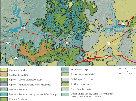
Most of the rocks surrounding the lake, including those that form the bedrock of the dam, belong to the Upper Triassic Chinle Group (Fig. 3). The Chinle Group consists of alternating layers of red-brown to buff to maroon to gray mudstone, siltstone, and sandstone that were deposited in continental fluvial and lacustrine environments about 220 million years ago. The Chinle Group is divided into five formations in this area: Santa Rosa, Garita Creek, Trujillo, Bull Canyon, and Redonda Formations (Lucas, 1995). The medium- to light-gray, massive to crossbedded sandstone exposed at the dam was called the “Logan Sandstone” by earlier geologists, but the unit was never formally described or named. More recent investigations indicate that it belongs to the Trujillo Formation, which extends into west Texas (Lucas et al., 1985; Lucas, 1995; Bureau of Economic Geology, 1977; Finch and Wright, 1983). The crossbeds in the sandstone are consistent with fluvial deposition. Mudcracks found in some sandstones indicate subaerial drying of mud, similar to that found in today’s climate at Ute Lake. The red color is produced by the oxidation of iron in the minerals forming the sandstone; this oxidation is common to seasonally arid events such as existed at the time the Chinle was deposited.
The base of the Garita Creek Formation is not exposed at the surface at Ute Lake, it unconformably overlies the Santa Rosa Sandstone in the subsurface. The Santa Rosa Formation consists of purplish-red to red-brown sandstone with a middle mudstone member (Lucas et al., 1985). Seepage in some excavations during construction of Ute Dam may have come from artesian water in the underlying Santa Rosa Formation (Graham, 1985). Artesian water in the Santa Rosa Formation also acts as an uplifting force on Ute Dam (Spiegel, 1972c; Graham, 1985).
Unconsolidated channel deposits of gravel and sand derived from the glaciated terrains in the Sangre de Cristo Mountains during the Pleistocene are found locally along the Canadian River above and below the dam. Some of these Pleistocene terrace deposits form the upper mesas overlying the Chinle Group. These units are locally 25 ft thick (Graham, 1985). In Ute Creek the Pleistocene deposits are fine sands with little or no gravels because these sediments were eroded from Triassic Chinle Group (Spiegel, 1972a-c). At Ute Dam surfical deposits of Recent alluvium overlie the Chinle Group and are locally as much as 70 ft thick (Graham, 1985). These deposits consist of mostly gravel and sand. Younger sand dunes locally overlie the older Pleistocene terrace deposits as well as the Chinle Group.
The Canadian River formed during the Pleistocene after the Wisconsin glaciation. The headwaters are in the Rocky Mountains in Las Animas County, Colorado, northwest of Raton, New Mexico. The river flows southeastward from the headwaters to Raton, where it flows south to Conchas Lake State Park. At Conchas Lake the river flows due east to Ute Lake State Park and eastward into west Texas and Oklahoma (Fig. 3). For most of the river’s course in New Mexico, it is a sinuous, meander belt that rarely exceeds 750 ft in width (Kessler, 1972). Floods since 1938 have eroded and degraded the river rather than deposited new stream deposits (Kessler, 1972).
References
- Bureau of Economic Geology, 1977, Geologic atlas of Texas, Tucumcari sheet: Bureau of Economic Geology, University of Texas (Austin), 1 sheet, scale 1:250,000.
- Finch, W. I., and Wright, J. C., 1983, Measured stratigraphic sections of uranium-bearing Upper Triassic rocks in eastern New Mexico, west Texas, and the Oklahoma Panhandle with brief discussion of stratigraphic problems: U.S. Geological Survey, Open-file Report 83-701, 118 pp.
- Graham, R. L., 1985, Engineering geology at two Canadian River dam sites; in Lucas, S. G. and Zideck, J. eds.), Santa Rosa–Tucumcari Region: New Mexico Geological Society, Guidebook 36, pp. 337–339.
- Julyan, R., 1996, The Place names of New Mexico: University of New Mexico Press, Albuquerque, 385 pp.
- Kesser, L. G., II, 1972, Channel geometry, development, and variation, South Canadian River, eastern New Mexico and West Texas; in Kelley, V. C., and Trauger, F. D. (eds.), East-central New Mexico: New Mexico Geological Society, Socorro, Guidebook 23, pp. 165– 167.
- Lucas, S. G., 1995, Triassic stratigraphy and chronology in New Mexico: New Mexico Geology, v. 17, no. 1, pp. 8–13, 17.
- Lucas, S. G., Hunt, A. P., and Morales, M., 1985, Stratigraphic nomenclature and correlation of Triassic rocks of east-central New Mexico: a preliminary report; in Lucas, S. G., and Zidek, J. (eds.), Santa Rosa–Tucumcari Region: New Mexico Geological Society, Guidebook 36, pp. 171–184.
- Reeves, C. C., Jr., 1972, Tertiary–Quaternary stratigraphy and geomorphology of west Texas and southeastern New Mexico; in Kelley, V. C., and Trauger, F. D. (eds.), East-central New Mexico: New Mexico Geological Society, Guidebook 23, pp. 108–117.
- Scott, G. R., 1986, Historic trail maps of the Raton and Springer 30’ x 60’ quadrangles, New Mexico and Colorado: U.S. Geological Survey, Miscellaneous Investigations Map I–1641, 2 sheets, 10 pp. text.
- Spiegel, Z., 1972a, Problems of the Triassic stratigraphy in the Canadian River basin, Quay, San Miguel, and Guadalupe Counties, New Mexico; in Kelley, V. C., and Trauger, F. D. (eds.), East-central New Mexico: New Mexico Geological Society, Guidebook 23, pp. 79-83.
- Spiegel, Z., 1972b, Cenozoic geology of the Canadian River valley, New Mexico; in Kelley, V. C., and Trauger, F. D. (eds.), East-central New Mexico: New Mexico Geological Society, Guidebook 23, pp. 118–119.
- Spiegel, Z., 1972c, Engineering problems at dam and reservoir sites in east-central New Mexico; in Kelley, V. C., and Trauger, F. D. (eds.), East-central New Mexico: New Mexico Geological Society, Guidebook 23, pp. 184–186.
- Young, J. V., 1984, The state parks of New Mexico: University of New Mexico Press, Albuquerque, 160 pp.