This document indicates how data collected at a point for faults, joints, and shear zones portrayed on a geologic map should be coded in the data model. See the NMBGMR Symbol set (3.7 Mb PDF) for details on how our standard symbology is constructed. If the fault measurement is for a mapped fault, set MappedFeat="yes" and remove the strike line from the symbol.
| Description | Symbol | Feature Classes & Attributes | Comment |
|---|---|---|---|
| joint-horizontal |  |
Fault_point
|
|
| joint-inclined | 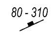 |
Fault_point
|
|
| joint-vertical | 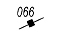 |
Fault_point
|
|
| minor_fault-inclined | 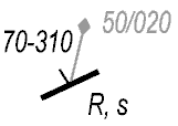 |
Fault_point
|
Minor fault not measured on a mapped fault. Slickenline in gray for clarity. |
| minor_fault-slickenline_rake | 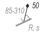 |
Fault_point
|
Minor fault not measured on a mapped fault. Fault plane in gray for clarity. How will we deal with which direction the rake is measured from? Should we use a direction like NE or should we give the azimuth of whichever side the rake was measured from? Alternatively, we could populate the trend and plunge fields when digitizing (need to do the math). |
| shearzone-inclined | 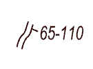 |
Fault_point
|