


GM-56—Geology of Capitol Dome quadrangle, Luna County, New Mexico
We are a research and service division of:
By R. E. Clemons, 1984, lat 32°07'30" to 32°15', long 107°37'30" to 107°45', scale 1:24,000.
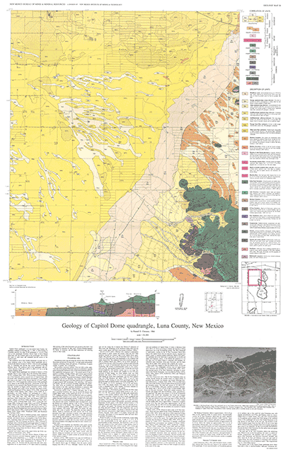
The second of four conterminous 7½-min quadrangles mapped as part of a comprehensive geologic and mineral-resource investigation of the Florida Mountains. The western Mimbres Basin and the northwest end of the Florida Mountains occupy much of the area mapped in east-central Luna County, immediately southeast of Deming. Others in this series are GMs 52, 59, and Memoir 43.
Capitol Dome quadrangle is in east-central Luna County, immediately southeast of Deming. NM-11 from Deming to Columbus parallels the edge of the quadrangle 0.1 mi (0.15 km) west of the quadrangle boundary. Paved roads to Rock Hound State Park cross the northern parts of the quadrangle, and several dirt roads to cattle tanks and windmills provide access to the southern parts.
The northwest end of the Florida Mountains occupies the extreme southeast corner of the Capitol Dome quadrangle and accounts for the highest elevation (7,100 ft; 2,164 m) in the quadrangle. Pediment and alluvial fans extend northwest into the Mimbres Basin. The northwest half of the quadrangle with elevations between 4,220 and 4,320 ft (1,286-1,317 m) is in the western Mimbres Basin.
$6.25
Buy
Now
Also available as a free download.
Download
| File Name | Size | Last Modified |
|---|---|---|
| GM-56_complete.zip | 22.18 MB | 02/05/2021 03:46:09 PM |
| GM-56_discussion.pdf | 12.55 MB | 02/05/2021 03:45:50 PM |
| GM-56_map.pdf | 10.08 MB | 02/05/2021 03:45:56 PM |
| GeoPDF: | ||
| CapitolDomeGeoPDF.pdf | 1.21 MB | 08/09/2021 08:50:50 AM |
| GISdata: | ||
| CapitolDome.mpk | 19.24 MB | 07/08/2021 04:32:14 PM |
| TIFF: | ||
| GM-56_map-pal.tif | 22.50 MB | 09/10/2018 02:31:28 PM |
| GM-56_map.tif | 124.55 MB | 09/10/2018 02:29:52 PM |