


Frequently Asked Questions About Water
We are a research and service division of:
- Where does our drinking water come from?
- What is the depth to groundwater in my area?
- Why do I have a well with low-quality water (or a small amount of water), while my neighbor has a good well?
- How do I determine the quality of my water? Is my water safe to drink?
- How can I protect our water resources?
- How do I determine my water rights?
- I’d like to drill a water well. What procedures are involved in drilling a well?
- Where does our drinking water come from?
-
Drinking water comes from two basics sources: surface water and ground water. These water sources are linked through the hydrologic cycle.

Schematic of the hydrologic cycle Initially, all of New Mexico’s water comes from precipitation, and the principal constraint on our water supply is climate. Most of New Mexico is a desert. A desert is defined as a region with a mean annual precipitation of 10 inches or less, and so devoid of vegetation as to be incapable of supporting any considerable population. Precipitation in New Mexico ranges from 6.7 inches at Shiprock to a maximum of 26.2 inches at Cloudcroft, but much of New Mexico receives less than 10 inches of water per year. Most of the precipitation that falls evaporates within a short time of reaching the ground (or sometimes before). Of the precipitation that reaches land without evaporating, much is taken up and used by plants (called transpiration). The rest either flows across the land surface into rivers and streams, or percolates into the ground, where it recharges underground aquifers. The portion of New Mexico where precipitation exceeds the combination of evaporation and transpiration (called evapotranspiration) is limited to a few areas of high elevation during the cool months of the year.
Surface water refers to all water located on the surface of the land—rivers, lakes and streams. New Mexico’s surface water supply originates as rain or melting snow, but 97 percent of that water evaporates or is transpired by plants.
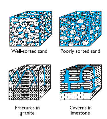
Different types of aquifers Most of New Mexico’s fresh water is stored as groundwater in aquifers below the land surface, where it occupies small open spaces between grains of sand or gravel and small cracks or fractures in rock. These cracks and void spaces are referred to as the porosity of the rock or sediment. All rocks that underlie the earth’s surface are classified as either aquifers or confining beds (also known as aquitards). An aquifer is a saturated rock unit or geologic formation that yields significant quantities of water to wells and springs. A confining bed (or aquitard) is a saturated geologic unit of less permeable material that is incapable of transmitting significant quantities of water, thus restricting the movement of ground water either into or out of adjacent aquifers. Ground water occurs in aquifers under two different conditions. In places where water only partially fills an aquifer, the upper surface of the water table is open to the atmosphere and is free to rise and fall in response to atmospheric pressure and changes in aquifer storage. The water in these aquifers is said to be unconfined, and the aquifers are referred to as unconfined aquifers or water-table aquifers. Where water completely fills an aquifer that is overlain by a confining bed, the water in the aquifer is confined under pressure and the aquifer is referred to as a confined or artesian aquifer.
For more information about our hydrogeologic research, see the Aquifer Mapping Program page.
- What is the depth to groundwater in my area?
-
The best source source of average depth to groundwater information in the state of New Mexico is the Water Column Report from the New Mexico Water Rights Reporting System (NMWRRS) maintained by the New Mexico Office of the State Engineer (OSE). This database can be searched using either Township-Range-section, State Plane, or UTM coordinate location information.
- Why do I have a well with low-quality water (or a small amount of water), while my neighbor has a good well?
-
The quality (and amount) of groundwater encountered in a well is strongly influenced by the rock types penetrated by a borehole. For example, a well penetrating limestone may produce water that is “hard”, meaning the water contains 150 to 300 ppm calcium carbonate, while a well penetrating ash flow tuff will be relatively soft, with water containing <75 ppm calcium carbonate.

How subsurface geology might affect water quality and quantity in adjacent wells. Abrupt changes in water quality (or amount) over short horizontal distances are usually related to the underlying geology. A geologic fault that might juxtapose a tuff against a limestone can cause a difference in water quality across property boundaries. Abrupt changes in rock type (e.g., a sandstone channel within a shale) can lead to sudden changes in water quality and quantity over a short horizontal distance.
Often, examination of a geologic map of your area can help you understand why your water well behaves differently than your neighbor’s water well.
- How do I determine the quality of my water? Is my water safe to drink?
-
The New Mexico Environment Department (NMED) regulates public water systems to ensure drinking water is safe. Their Drinking Water Watch website allows the public to search their water sampling database and also has programs offering free testing of private domestic well water. There are also a number of commercial laboratories in New Mexico that can analyze drinking water for biological and chemical contaminants.
The U.S. Geological Survey also monitors both surface and ground water quality at many localities in the state of New Mexico.
- How can I protect our water resources?
-
The US EPA has these suggestions for protecting drinking water:
- How do I determine my water rights?
-
Hydrologists at the Bureau of Geology are concerned with measuring and documenting the geologic characteristics of aquifers. The Office of the State Engineer (OSE) manages water rights issues. Visit the webpage for the Office of the State Engineer for information about rules, regulations, and guidelines related to water use in New Mexico.
Water rights information can be found in the New Mexico Water Rights Reporting System (NMWRRS) on the OSE website. This system can be searched using either Township-Range-section information, State Plane coordinates, or UTM coordinates.
- I’d like to drill a water well. What procedures are involved in drilling a well?
-
Hydrologists at the Bureau of Geology are engaged in practical research and field studies that delineate and characterize New Mexico’s streams and aquifers, and evaluate water quality problems. The Office of the State Engineer is charged with issuing well drilling permits and overseeing the diversion and beneficial use of the State’s waters. Visit the webpage for the Office of the State Engineer for information about well-drilling procedures, permits, and fees.