


Geologic Mapping Program
Open-File Geologic Map Series (OF-GM)
Recent Open-file Geologic Maps
Some publications, including
those that are out-of-print, are only available for purchase on CD or DVD-ROM ![]() .
.
| Stock# | Title | Price / Details |
|---|---|---|
| OF-GM-304 |
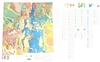 Geologic Map Database of New Mexico, adapted from Geologic Map of New Mexico, New Mexico Bureau of Geology and Mineral Resources, 2003, Scale 1:500,000, New Mexico Bureau of Geology and Mineral Resources, 2022 (Revised: 12/20/22), Scale 1:500,000, [CD/DVD-ROM on demand].
|
$10.00Buy Now
|
| OF-GM-303 |
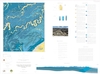
 3D Geologic Model of Aquifer-Bearing Units of the Delaware Basin, New Mexico, Marissa M. Fichera and Snir Attia, 2022 (Revised: 9/7/22), Scale 1:250,000, [CD/DVD-ROM on demand].
|
$10.00Buy Now
|
| OF-GM-302 |
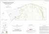
 Geologic Map of the Taylor Well 7.5-Minute Quadrangle, Dona Ana County, New Mexico, Shari A. Kelley and Shannon Rees, 2022 (Revised: 9/7/22), Scale 1:24,000, [CD/DVD-ROM on demand].
|
$10.00Buy Now
|
| OF-GM-301 |
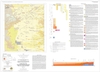
 Geologic Map of the Serpentine Bends 7.5-Minute Quadrangle, Eddy County, New Mexico, Steven J. Skotnicki and Snir Attia, 2022 (Revised: 9/7/22), Scale 1:24,000, [CD/DVD-ROM on demand].
|
$10.00Buy Now
|
| OF-GM-300 |
 Geologic Map of the Rayo Hills 7.5-Minute Quadrangle, Socorro County, New Mexico, Scott B. Aby and Andrew P. Jochems, 2022 (Revised: 9/7/22), Scale 1:24,000, [CD/DVD-ROM on demand].
|
$10.00Buy Now
|
Show All Open-file Geologic Maps
Notes:
These maps are open-filed as they become available, initially as PDF files of scans of the hand-drawn linework and later as full color maps and GIS products. Following cartographic production and editorial review, these maps may be published within our GM-series or be included in larger maps of regions of particular interest.
These maps are subject to frequent revisions and may be unavailable when being revised. Map Reference dates show the time of initial compilation; Map Revision dates, when given, indicate the most current version of the map; Last Modified dates for files may not, accurately reflect the time the map was last revised.
Please direct comments or requests regarding these maps to either the map authors or the Geologic Mapping Program Manager.