


Prehistoric Trackways National Monument
We are a research and service division of:
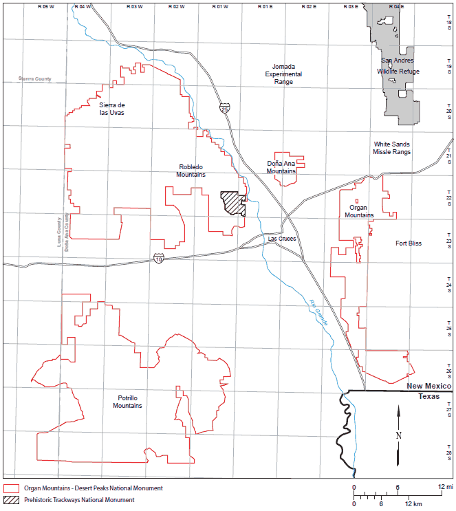
Introduction and Location
The Prehistoric Trackways National Monument is located in the Robledo Mountains just northwest of Las Cruces in Dona Ana County, south-central New Mexico. It contains rocks of Permian age, from the Late Paleozoic Era. They are composed of sediments deposited about 280 million years ago, before the age of the dinosaurs. These rocks contain major deposits of fossilized footprints made by numerous amphibians, reptiles, insects, and crustaceans, as well as plants and petrified wood. Some scientists have called these features the most scientifically significant Permian tracksites in the world. These fossils provide important information about animal behavior in this ancient tropical environment on the edge of the supercontinent Pangea.
The monument was created in 2009 as the 100th active national monument in the United States. The monument is comprised of 5,280 acres of undeveloped terrain, and does not yet have a visitor center, campground, or other facilities (as of early 2015), but facilities development is in the planning stages. The monument is open to the public. According to the U.S. Bureau of Land Management, which manages the monument, it was established to “conserve, protect, and enhance the unique and nationally important paleontological, scientific, educational, scenic, and recreational resources and values” of this unique site. Hiking in the monument is permitted, but collecting rocks containing tracks is not. There are no roads inside the monument, but vehicle access to the eastern border is available from the north or from Las Cruces to the south.
Coming from the North: Exit Interstate 25 at the Dona Ana Exit onto N.M. 320. From N.M. 320 (Thorpe Road) in Doña Ana, go west to U.S. Highway 85. Turn right (north) for about 0.5 mile. Turn left (west) on Shalem Colony Trail. Go about 1.5 miles until you cross over the Rio Grande, and take a right onto Rocky Acres Trail. Go approximately ¼ mile and then turn left onto the only dirt road that goes west, Permian Track Road. Cross over a cattle guard and continue to the west. After about a mile this road may require 4WD.
Coming from the South (Las Cruces): Travel west on Picacho Ave./U.S. Hwy. 70. Turn right (north) onto Shalem Colony Trail at the stop light. Go about 5.5 miles. Prior to reaching the Rio Grande, you will come to a county road, Rocky Acres Trail. Turn left (west) here. Go approximately ¼ mile and then turn left onto the only dirt road that goes west, Permian Track Road. Cross over a cattle guard and continue to the west. After about a mile this road may require 4WD.
Geologic History
Regional Geologic Setting
The Prehistoric Trackways National Monument is located in the southern portion of the Rio Grande rift, which bisects New Mexico from north to south. At this point, the rift is about 100 miles wide, with the Robledo Mountains on the extreme western edge. The rift is an area of crustal extension that runs from Colorado to northern Mexico. The Rio Grande flows roughly down the axis of the rift. Extension began approximately 36 million years ago, with maximum extension rates occurring about 10 to 16 million years ago, although movement continues today. The area of greatest extension is in the south. The rift is characterized by a series of normal faults, some with tens of thousands of feet of displacement, creating a series of roughly north-south trending basins bordered by mountain ranges. Some basins contain in excess of 15,000 feet of sediments. Fault block mountain ranges expose sediments of all ages; the Robledo Mountains are predominantly Permian in age. In addition, all along the Rio Grande rift, volcanic vents associated with the rifting process have created individual volcanoes and extensive volcanic fields. The Robledos contain some of these volcanic rocks.
To the east beyond the Guadalupe Mountains lie the Southern High Plains, which is a large area of relatively undeformed sediments of Permian and Triassic age. These rocks are capped in places by the Tertiary Ogallala Formation, a major aquifer used for irrigation. Known here as the Permian Basin, the region contains large accumulations of oil and gas, and most of the potash resources in the U.S.
Just to the west of the Robledo Mountains, the Basin and Range province begins. It extends from central New Mexico to eastern California, and from Idaho south into Mexico. Over the past 30 million years the Earth’s crust has been stretched, causing a series of normal faults that created a horst and graben terrain, now expressed as a series of narrow, north-south trending, rugged mountain ranges interspersed with wide basins. This arid to semi-arid region has limited water resources (the Colorado River is a notable exception), but contains significant copper deposits.
Iron deposits were discovered in Hueco Group limestones in the southwestern Robledo Mountains (outside of the Prehistoric Trackways National Monument), but are unlikely to be mined in the future due to small tonnages and low grade. A large rock quarry located just outside the eastern boundary of the monument called the Community Pit #1 was sporadically mined for about 40 years, but is now closed. It probably produced less than a million tons of building stone used for construction and landscaping in local markets.
Sedimentary History
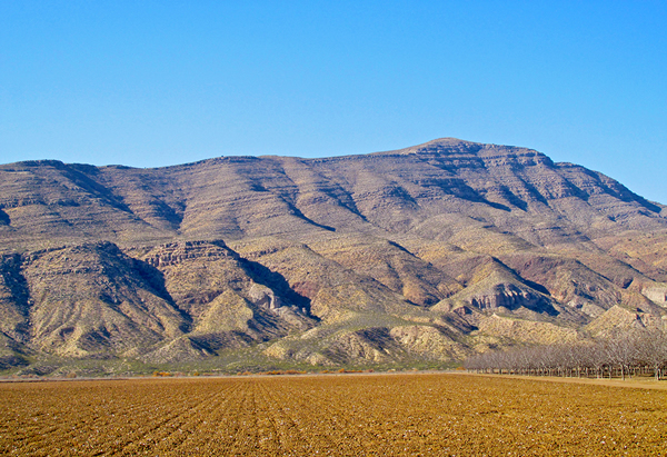
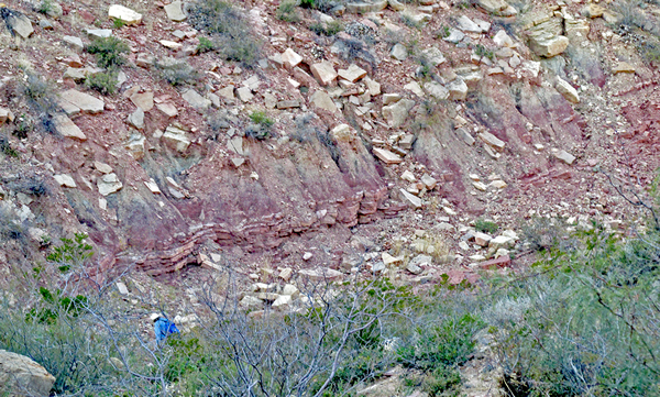
The Prehistoric Trackways National Monument is located in the southeast portion of the Robledo Mountains, which rise more than a thousand feet above the Rio Grande valley immediately to the east. About 10 miles by five miles in size, this range is a wedge-shaped block of Permian and Tertiary rocks that dip 10-14 degrees to the south (Hawley et al., 1975). The Tertiary deposits include igneous intrusions, mostly in the northern part of the range, and andesitic volcaniclastic sedimentary rocks with some lava flows in the south (Wilks, 2005). The flanks of the range also contain river and floodplain deposits of the late Pliocene-early Pleistocene Santa Fe Formation, and conglomerates, sandstones, and mudstones of the Love Ranch and Palm Park Formations of Eocene age.
Most of the Robledo Mountains expose a thick section of Early Permian sedimentary rocks. This section, originally known as the Hueco Formation, was divided into several members. In 1998, Lucas et. al. elevated the Hueco to group status, and its members to formations. In the Robledos, the Hueco Group is more than 1,500 ft thick, and includes (from oldest to youngest) the Shalem Colony, Community Pit, Robledo Mountains, and the Apache Dam Formations (Lucas et. al., 1998b).
The Hueco Group was laid down about 280 million years ago, when all of the Earth’s land masses had come together to form the supercontinent Pangea, and this region was near the shore of a shallow tropical sea called the Hueco Seaway (Lucas, 2011). Most of these sediments were deposited off-shore, and include interspersed limestone, siltstone, and shale. These layers represent different depositional environments as the supply of clastic material derived from land changed over time, and the distance to the shore varied from nearby to relatively distant. Abundant marine fossils are present in numerous strata, including brachiopods, bryozoans, crinoids, echinoids, sponges, corals, fusulinids, and mollusks, including gastropods, bivalves, and ammonites (Lucas, et al., 1998a). Microfossils abound, and tree logs floated off-shore and were preserved in the marine sediments.
The other formations of the Hueco Group are marine in origin, but the Robledo Mountains Formation contains continental sediments interlayered with yellowish-gray marine shales and gray limestones. Sea level fluctuated during these times, and the continental deposits reflect periods when the sea level dropped low enough to expose the shallow sea floor. The sea level declines were due in part to increased glaciation elsewhere across the globe, which locked up water in continental ice sheets and glaciers. Shoreline, tidal mudflat, and river floodplain environments replaced the marine regions, laying down red beds of fine-grained calcareous sandstones, siltstones, and mudstones.
The Trackways
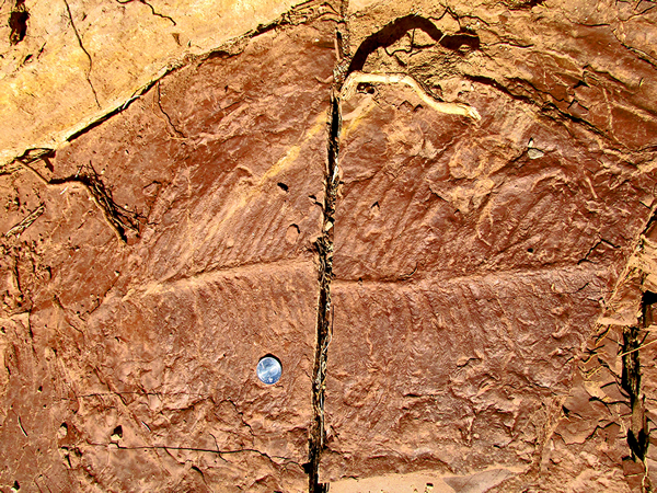
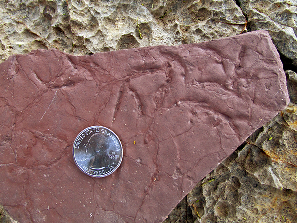
Life was abundant in this tropical environment. Forests, comprised predominantly of an early conifer tree called Walchia were widespread along the floodplains. These trees were covered with short needles on fronds, and looked very similar to today’s Norfolk Island pine. Numerous Walchia fronds were preserved in great detail in the Robledo Mountains Formation. Other types of plant fossils are rare.
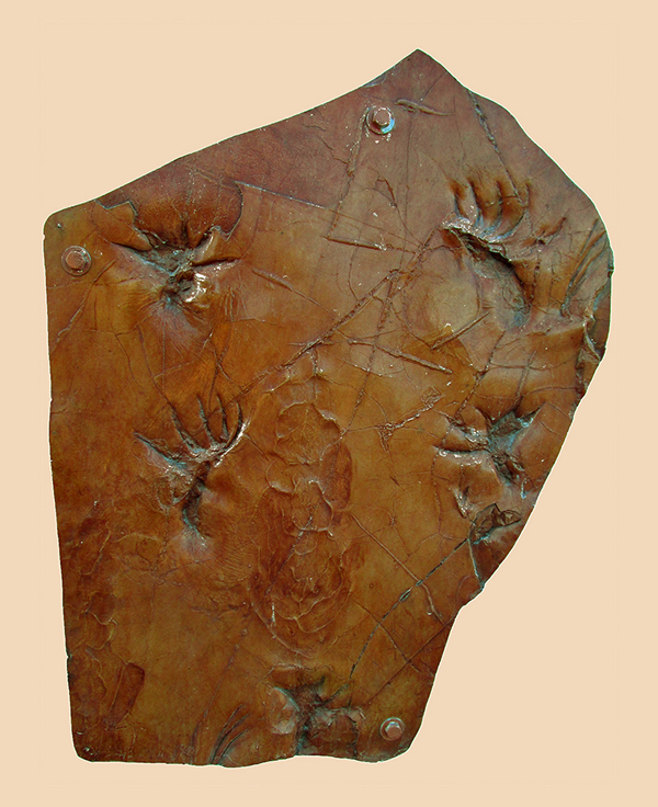
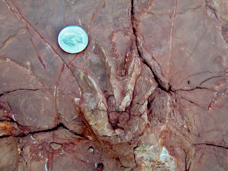
The most notable features in the Prehistoric Trackways National Monument are the animal fossils found at numerous sites in the vicinity, often associated with Walchia fronds. Bones and teeth are not preserved here, although they are common in formations of similar ages farther north in Socorro, Sandoval, and Rio Arriba Counties in New Mexico, as well as other western states. However, trace fossils, also known as ichnofossils, are everywhere. Trace fossils are geologic records of biological activity. Footprints, body impressions, burrows, drag marks from various parts of the body like the tail and belly, and even marks left by swimming just above the bottom are preserved in fine detail. Invertebrates and vertebrates all left their marks, including ancient arthropods (insects), crustaceans, amphibians, and reptiles (Lucas et al., 1998b).
While Early Permian tracksites are found in other locations, the Robledo Mountains stand out for the sheer numbers of fossils, the large number of species represented, and their high quality and excellent preservation. Up to 50 consecutive prints from individual animals are seen, and tracks from multiple species are found together. Analyzing track patterns gives clues as to animal behavior, including movement, interactions with each other, and the environment in which they lived.
Several dozen trackway sites have been identified in the Robledo and nearby Dona Ana Mountains, but the Discovery Site is the most significant. Found by Jerry MacDonald in 1987, it has produced the most extensive collections of tracks, some of which can be seen at the New Mexico Museum of Natural History and Science in Albuquerque, N.M.
The Animals
A variety of animal tracks are preserved in the Prehistoric Trackways National Monument. Paleontologists have named the tracks themselves, as it can be difficult to identify the type of animal responsible, especially when no bones or other body parts are preserved in association with the tracks, which is the case in the Robledo Mountains trackways. However, many tracks resemble those made by certain species alive today, providing evidence regarding the ancient creatures crossing the mud. Lucas, 2011 provides additional information on the trace fossils described below.
Tracks from invertebrates such as arthropods and crustaceans are the most common. Primitive insects, like beetles, create tracks called Lithographus. These animals had six legs, three on each side of the body. The tracks are tiny and linear, and found in groups of three, representing one mark for each leg on one side of the body. Scorpion-like animals likely created Palmichnium and Octopodichnus tracks, using their eight legs, and paddle-shaped limbs or pincers. Selenichnites imprints were probably left behind by the crescent-shaped head shield of a primitive horseshoe crab. When walking, Kouphichnium footprint trackways were left behind by a horseshoe crab. Worm-like creatures burrowed in the sediment, leaving behind a series of curved Augerinoichnus traces. Undichnia fossils were created when a fish swam near the bottom, and its fins skimmed the sediment. Flexing its body back and forth as it swam created the undulating imprints.
Vertebrates such as amphibians and reptiles created other tracks found in the Prehistoric Trackways National Monument. Batrachichnus are the most common vertebrate tracks in the Robledo Mountains, and were made by an amphibian resembling a salamander that had four toes on the front feet and five on the back. They resemble a smaller version of a human baby’s handprint.
True lizards would not evolve for another 100 million years, but Dromopus tracks look very similar to those of today’s lizards. The animal had five thin toes of different lengths on each foot. The toes have a characteristic curvature. Some specimens show marks of joints, scales, and claws. This early reptile probably ate insects.
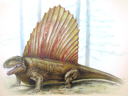
The largest predator in this ecosystem was the Dimetrodon, and its tracks are called Dimetropus. Fossil bones and teeth of this creature have been found in Texas and Oklahoma. Up to 13 ft long and 500 lbs, it had teeth of various sizes and a large sail on its back. The sail was formed from spines projecting from the vertebrae. Reptile-like in appearance, it is often mistaken for a dinosaur, but went extinct about 40 million years before the first dinosaurs appeared. Classified as a synapsid and also called a pelycosaur, it is more closely related to mammals than reptiles.
Interpretations of the body posture of the Dimetrodon based on skeletal analysis from other sites indicated a low, squat animal with splayed limbs. However, analysis of Dimetropus trackways in the Prehistoric Trackways National Monument indicates the animals may have had a semi-erect posture with body and tail held higher, allowing faster motion. Evidence for this includes a lack of tail or belly drag marks, and the position and location of tracks in a set made by an individual (Hunt and Lucas, 1998).
For additional information about visiting the Prehistoric Trackways National Monument and the status of future facilities improvements, contact the Las Cruces, N.M. District Office of the U.S. Bureau of Land Management at (575) 525-4300.
References
- Hunt, A.P., and Lucas, S.G., 1998, Vertebrate Tracks and the Myth of the Belly-Dragging, Tail-Dragging Tetrapods of the Late Paleozoic in Permian Stratigraphy and Paleontology of the Robledo Mountains, New Mexico: El Paso Geological Society Fieldguide, New Mexico Museum of Natural History and Science Bulletin 12, p. 67-69.
- Lucas, S.G., 2011, Traces of a Permian Seacoast: New Mexico Museum of Natural History and Science and U.S. Bureau of Land Management, 49 p.
- Lucas, S.G., Anderson, O.J., Heckert, A.B., and Hunt, A.P., 1995, Geology of early Permian tracksites, Robledo Mountains, south-central New Mexico:New Mexico Museum of Natural History and Science Bulletin 6, p. 13–32.
- Lucas, S.G., Heckert, A.B., Estep, J.W., Hunt, A.P., and Anderson, O.J., 1998a, Stratigraphy, Paleontology and Depositional Environments of the Lower Permian Robledo Mountains Formation of the Hueco Group, Robledo Mountains, New Mexico in Permian Stratigraphy and Paleontology of the Robledo Mountains, New Mexico: El Paso Geological Society Fieldguide, New Mexico Museum of Natural History and Science Bulletin 12, p. 29-41.
- Lucas, S.G., Heckert, A.B., Estep, J.W., Hunt, A.P., and Cook, C.W., 1998b, Stratigraphy of the Lower Permian Hueco Group in the Robledo Mountains, Dona Ana County, New Mexico in Permian Stratigraphy and Paleontology of the Robledo Mountains, New Mexico: El Paso Geological Society Fieldguide, New Mexico Museum of Natural History and Science Bulletin 12, p. 43-54.
- Hawley, J.W., Seager, W.R. and Clemons, R.E., 1975, Third day road log from Las Cruces to north Mesilla Valley, Cedar Hills, San Diego Mountain, and Rincon area: New Mexico Geological Society Guidebook 26, p. 35-53.
- Wilks, M.E., compiler, 2005, New Mexico Geologic Highway Map: New Mexico Geological Society and New Mexico Bureau of Geology and Mineral Resources, 1:1,000,000.