


GM-50—Precambrian rocks of Red River–Wheeler Peak area, New Mexico
We are a research and service division of:
By K. C. Condie, 1981, lat approx. 36°25'00" to 36°45'00", long approx.105°15'00" to 105°30'00", text, 1 sheet, scale 1:48,000.
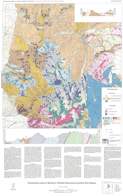
This map covers an area bounded by Cabresto Creek drainage (north), Lucero Canyon (south), the escarpment of the Sangre de Cristo Mountains (west), and the Moreno Valley (east).
Precambrian rocks underlie much of the area; they are intruded by Tertiary plutons and are unconformably overlain by late Paleozoic sediments and Tertiary volcanics. The rocks are also intruded by numerous felsic dikes of Tertiary age (some larger dikes are shown on map). Precambrian rock in the area is generally poorly exposed with the only continuous outcrop occurring on the high mountain ridges. Tertiary deformation and magmatism have resulted in varying degrees of alteration of the Precambrian rocks. The most intensely altered areas are noted on the map.
Precambrian rocks in the area comprise three categories: metasediments, metavolcanics (including hypabyssal rocks), and granites. All supracrustal rocks (rocks formed at or near the earth's surface) except the diabase dikes are metamorphosed to the amphibolite facies. Successions in which sedimentary rocks dominate occur around the outer part of the map area; those in which volcanic rocks dominate occur in the central part. The granitic rocks consist of two types: granite (including quartz monzonite) and tonalite-trondhemite. Both are intrusive into supracrustal rocks; the granites also intrude the tonalite-trondhemite. Although the rock types recognized by McKinley (1956, 1957) were also recognized, the distribution he proposed could not be verified. The fourfold subdivision of Precambrian rocks proposed by Clark and Read (1972) could not be substantiated in any way. In addition, some of the lithologic types proposed by these authors are either nonexistent (such as granulite) or very minor (such as migmatite).
$6.00
Buy
Now
Also available as a free download.
Download
| File Name | Size | Last Modified |
|---|---|---|
| GM-50_complete.zip | 15.75 MB | 02/05/2021 03:37:40 PM |
| GM-50_discussion.pdf | 1.02 MB | 02/05/2021 03:37:26 PM |
| GM-50_map.pdf | 15.09 MB | 02/05/2021 03:37:31 PM |
| TIFF: | ||
| GM-50_map-pal.tif | 27.88 MB | 09/11/2018 02:39:33 PM |
| GM-50_map.tif | 162.12 MB | 09/11/2018 02:37:11 PM |