


GM-9 — Geologic Map of Foster Canyon Quadrangle, Valencia and McKinley Counties, New Mexico
We are a research and service division of:
By Clay T. Smith and others, 1958, scale 1:48,000.
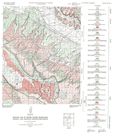
This map covers a portion of the Zuni Mountains in the vicinity of the Continental Divide west of Thoreau, New Mexico. Precambrian igneous rocks core the Zuni Mountains and are overlain by Pennsylvanian to Cretaceous sedimentary rocks.
Note: This is a companion map to GM-4 (Inscription Rock) to the south. Also, since this map was published, Valencia County was split making this area part of what is now Cibola County.
$3.25
Buy
Now
Also available as a free download.
Download
| File Name | Size | Last Modified |
|---|---|---|
| GM-9_map.pdf | 9.97 MB | 02/05/2021 02:49:30 PM |
| TIFF: | ||
| GM-9_map-pal.tif | 9.49 MB | 09/19/2018 03:24:10 PM |
| GM-9_map.tif | 73.23 MB | 09/19/2018 03:22:40 PM |