


RM-5 — Thickness of the Permian Guadalupian Capitan Aquifer, Southeast New Mexico and West Texas
We are a research and service division of:
W. L. Hiss, 1975, Scale 1:500,000.
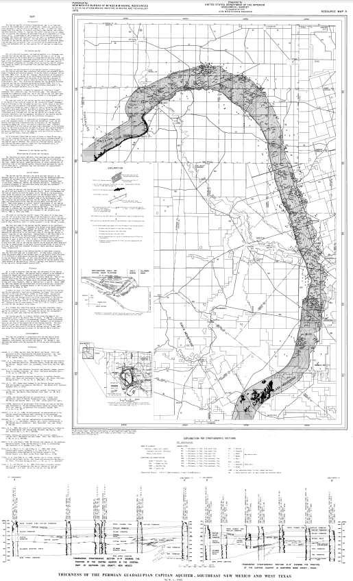
The Capitan aquifer of Permian (Guadalupian} age is an important source of the ground water used for municipal, industrial, and agricultural purposes in the vicinity of Carlsbad, N. Mex. In addition, water pumped from this aquifer in southern Lea County, New Mexico, and Winkler and Ward Counties, Texas, is injected into other reservoirs by oil companies to increase the recovery of petroleum from partly depleted oil fields (Hiss, 1971). A knowledge of the dimensions of the Capitan aquifer in southeast. New Mexico and west Texas will be useful in programs designed to manage this important resource. The map depicting the position and thickness of the Capitan aquifer will also be helpful to petroleum companies who may wish to control "lost circulation" while penetrating this porous and permeable unit as they explore for oil and gas in underlying strata.
$3.50
Buy
Now
Also available as a free download.
Download
| File Name | Size | Last Modified |
|---|---|---|
| RM-5.pdf | 6.31 MB | 02/16/2021 03:53:57 PM |