


Cabezon Peak and the Rio Puerco Necks
We are a research and service division of:
Introduction and Location
Author photo
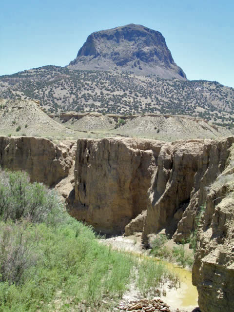
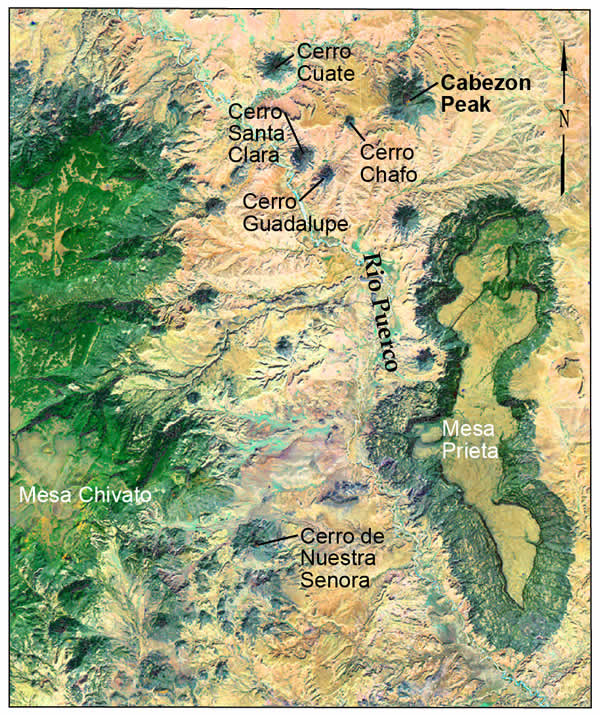
Cabezon Peak is one of the best-known and most visible landmarks in northwest New Mexico. This giant volcanic plug is visible for tens of miles in all directions, and as far away as Placitas. Cabezon means “big head” in Spanish, and it is aptly named. It is the largest of several dozen widely scattered rocky monoliths, called the Rio Puerco necks. Rising above the Rio Puerco valley floor, they are some of the best-preserved examples of volcanic necks in the world. The craggy black peaks stand in sharp contrast to the sparsely vegetated, buff-colored lowlands from which they emerge. Mt. Taylor looms majestically to the southwest, Mesa Prieta borders the valley to the east, and the Jemez Mountains are visible to the north. This starkly beautiful landscape is unique in New Mexico. At an elevation of 7,786 ft, Cabezon Peak towers more than 1,100 ft above its base, and 2,000 ft above the Rio Puerco nearby.
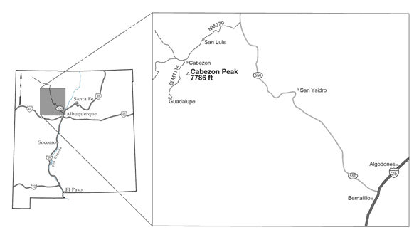
Cabezon is located about 75 miles northwest of Albuquerque (Figure 2). From Albuquerque, travel 17 miles north on I-25 to Bernalillo and take Exit 242, U.S. Highway 550 west. Travel 41 miles to N.M. 279. Turn west (left) at the sign that reads “San Luis, Cabezon, Torreon.” Drive 8.4 miles to the end of the pavement, and continue four more miles until the road forks. Veer left onto BLM 1114 and continue another 3.8 miles (16.2 miles from U.S. 550). Turn left at a BLM sign for Cabezon Peak, and drive .9 miles to the parking area below Cabezon’s west face.
Geologic History
Regional Geologic Setting
Cabezon Peak sits near the junction of three physiographic provinces; it is on the far eastern edge of the Colorado Plateau, and just west of the Rio Grande rift and the southern end of the Southern Rocky Mountains. Cabezon and the Rio Puerco necks are also located in the southeast corner of the San Juan Basin. The necks are volcanic features that are related to volcanism at Mt. Taylor and Mesa Chivato to the west. Erupted between four and 1.5 million years ago, the Mt. Taylor volcanic field is part of a string of late Cenozoic (less than five million years old) volcanic features that stretch in a northeasterly direction across the entire northern half of the state, called the Jemez Lineament. This feature is a zone of volcanism aligned along an ancient suture in the 1.7 to 1.6 billion year old Proterozoic basement (Mayo, 1958; Laughlin et al., 1976; Perry et al., 1990). Just to the east, a series of north-trending normal faults marks the western edge of the Rio Grande rift, which is a series of down-dropped basins that extends from Colorado to Mexico. Crustal stretching and basin subsidence in the rift continue today. The upper Rio Puerco valley is in a transition zone between the rift and the Colorado Plateau, and it contains the Rio Puerco fault zone, which is a series of en-echelon, north-northeast-trending faults about 50 miles long. This fault zone initially formed as a result of compression during the Laramide orogeny, and was later re-activated during extension associated with the Rio Grande rift development (Slack and Campbell, 1976).
Sedimentary History
Author photo
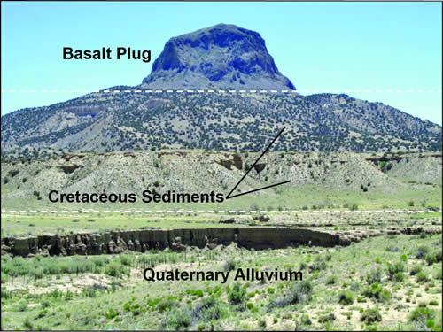
The floor of the Rio Puerco valley that contains Cabezon and the Rio Puerco necks is composed primarily of Cretaceous and Jurassic sediments that generally get older to the south. Rocks in this region primarily are flat-lying or dip gently to the northwest. In the northern and central portions of the valley, formations exposed at the surface include the Point Lookout Sandstone, the Crevasse Canyon Formation, the Mulatto Tongue of the Mancos Shale, the Gallup Sandstone, and the Lower Mancos Shale, (all within the Mesaverde Group), plus the Dakota Sandstone. Farther south, exposures of the Jurassic Morrison Formation and San Rafael Group can be found (Wilks, 2005). These sediments were deposited in marine, near-shore, and transitional environments.
Many of these formations were exposed at the surface when volcanism associated with the Mt. Taylor volcanic field covered them. The Rio Puerco has evolved as a major drainage in the region in the past few million years, and has accelerated erosion in the valley. These sediments erode fairly quickly when vegetation is sparse and summer rain events are powerful. Some of the lowland stream and arroyo channels contain Quaternary alluvium. The slopes of Mesa Chivato to the west and Mesa Prieta to the east are steep enough that landslides occur, and some of these deposits are preserved.
Volcanic Features
Author photo
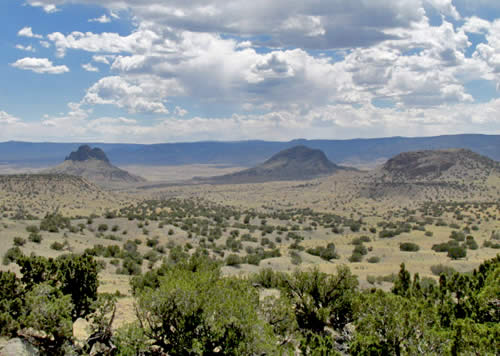
The northern segment of the Rio Puerco valley extends from the Mt. Taylor volcanic field eastward about 10-20 miles. The most notable features are the volcanic necks that rise above the valley floor. The necks are the erosional remnants of volcanoes that were created as part of the Mt. Taylor volcanic field and represent a variety of erosional stages.
Beginning around four million years ago, magma exploded at the surface and continued intermittently for the next 2.5 million years. This relatively long-lasting series of volcanic eruptions created Mt. Taylor, a huge composite volcano. Volcanic activity spread to the northeast and formed what is now Mesa Chivato, which contains many cinder cones, fissure vents, collapse craters, marrs, and trachyte domes (Abuele et al., 1976). Sufficient material was extruded to cover this region in lava hundreds of feet thick in places. The location of eruptions shifted over time, migrating further northeast to the area that is now Mesa Prieta. The Rio Puerco valley lies between these two mesas. It is likely that Mesa Chivato and Mesa Prieta once were part of one continuous volcanic plateau that formed between 3.5 and 2 million years ago (Hallett, 1992). Basalt at Cabezon Peak is 2.6 million years old.
Author photo
During and after this time the Rio Puerco flowed around the east side of Mt. Taylor and accelerated erosion along its course, eroding away most of the volcanic material in what is now the valley and exposing the underlying sediments. Volcanism on Mesa Chivato was more extensive with larger accumulations, and volcanism at Mesa Prieta is younger. Both are somewhat removed from the main Rio Puerco drainage, and therefore subject to less erosion than along the river itself, so portions of the original plateau are still preserved in these locations. However, in the lowlands along the Rio Puerco, only the cores of volcanic vents remain, along with limited lava flows and some dikes. Only at this particular moment in geologic time can we see these volcanic cores; in a few million years’ time, they will vanish as erosion continues.
Petrography
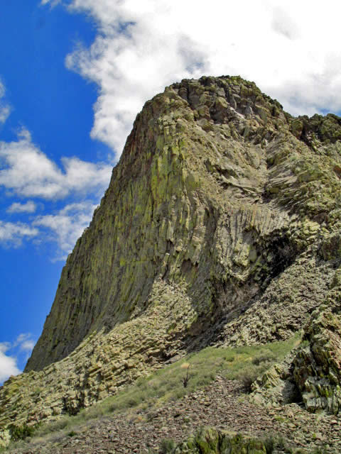
The necks are fine-grained, porphyritic basalts that are surprisingly consistent in mineralogy and texture. They contain up to 20 percent olivine, clinopyroxene, plagioclase, and magnetite phenocrysts (Hallett, 1992). Mantle and crustal xenoliths are found in about two thirds of the necks. Most are ultramafic varieties including periditites, websterites, dunites, harzburgites, clinopyroxenites, and orthopyroxenites (Kudo et al., 1971, Wilshire et. al., 1988). The bulk of Cabezon Peak is composed of non-vesiculated, fine-grained, porphyritic, olivine basalt. Lava flows are similar in mineral composition to the necks they are associated with. Flows are fairly limited in extent and often interbedded with pyroclastic material. Dikes in the Rio Puerco valley are fine- to medium-grained, hypocrystalline basalts that are very similar in their mineralogy to the necks and flows, but can have a glassy matrix (Hallett, 1992).
Cinder Cone Development
Author photo
The volcanic necks of the Rio Puerco valley are the remnants of cinder cones. A typical cinder cone is born when a fissure in the crust allows magma to reach the surface. Pyroclastic material is ejected into the atmosphere, and falls back to form layers of scoria, ash, and spatter in a ring around the vent. Through time, repeated eruptions cause the cone to grow wider and taller, with material piling up and reaching the angle of repose. A deep crater develops around the vent with ash and scoria sliding down the outside and back into the interior of the crater. Welding of material on the inside of the crater by partially molten ejecta may further steepen the crater’s interior walls. As the magma source depletes, the composition changes and a decrease in dissolved gas content often results in less explosive eruptions and more liquid extrusions that can breach the top or sides of the crater and spread out over the landscape as lava flows. As volcanism winds down, the neck of the volcano fills up with scoria, ash, spatter, bombs, and material eroding off the upper portions of the crater walls. This material often is cemented to varying degrees with liquid magma that oozes into the mass, making it more resistant to erosion than the rest of the cone. Subsequent erosion removes the outer portions of the cinder cone, leaving only the neck.
In some cases, during the last stages of eruption of a larger cinder cone, liquid magma can pool in the crater forming a deep lava lake, which eventually cools. When this occurs, the neck can be called a plug, although usage of these two terms is sometimes synonymous (Hallett, 1992). The lava shrinks as it solidifies, creating a series of parallel fractures, or joints, that generally form perpendicular to the nearest cool surface. These fractures propagate downward and inward, forming regular hexagonal columns. Near the top of the plug the columns are vertical. But in the lower portions of the plug, the nearest cool surface is the surrounding country rock, not the upper surface of the plug. Here, the columns form at increasingly shallower angles as depth increases. This creates a plug with vertical columns near the top that flare out at the bottom. The Cabezon columns range in size from two to eight feet in diameter. Subsequent erosion removes the outer material, and for a short period of geologic time, the plug is fully exposed. Most of the features in the Rio Puerco valley are necks, but Cabezon and Cerro de Nuestra Senora are spectacular examples of plugs. Well-developed columns are visible on the sides of both of these plugs. Columnar jointing is also present in some of the necks, but is irregularly developed because the liquid magma, which forms columns, is interspersed with pyroclastic material, which does not.
Viewing the necks and plugs today might give the impression that these masses continue downward with similar dimensions in the subsurface. However, cross sections of volcanoes exposed by erosion, and drilling beneath a neck called Cerro Negro show that the necks are basalt masses that rapidly narrow downward to feeder dikes that may be only a few feet in diameter. This indicates that magma made its way upward through a narrow conduit, which then created a much wider cinder cone on the surface (Crumpler, 2010).
The Rio Puerco necks provide valuable clues regarding the characteristics of the Mt. Taylor volcanic field. These cores allow us to actually see the interior of volcanoes, and therefore provide detailed information about the formation of cinder cones and how they vary. The necks are similar in age, composition, structure, and formation to volcanic features on Mesa Chivato and Mesa Prieta, differing primarily in the extent of erosion. Therefore, by studying them we better understand the uneroded features on the surrounding mesas.
Climbing Cabezon Peak
The best way to understand the geology of the necks and plugs is to go see them. Exploring different necks and plugs illustrates the varied rock types and formation processes. The vertical columns of black basalt that make up the bulk of Cabezon are a magnet for experienced rock climbers, and a number of routes have been tested. However, they are not for the faint of heart, and should only be attempted with proper climbing gear and expert knowledge. For more information, contact the New Mexico Mountain Club.
If you are a strong hiker and comfortable with scree slopes, scrambling, and a bit of climbing, there is an "Easy Way" to summit Cabezon Peak that is non-technical (no ropes required). However, the route is Class 3, with a couple of very short sections that verge on Class 4. From the parking area, an obvious trail heads steeply uphill to the east through Cretaceous sediments. After nearly a mile, on the southeast shoulder of the peak you will see a large rock cairn and a ten-foot-long rock arrow pointing towards a chimney in the rock face above. Here you head up a steep braided trail of loose dirt and basalt rock. In and above the chimney, you will find a mix of rocky trail, boulder hopping, and two places that require finding handholds and footholds to pull yourself up. The last short stretch returns to a good trail and the summit. The 360-degree views from the top are spectacular; this is New Mexico at its best. Round trip hiking time is 3-4 hours. For a more detailed description of the summit hike, see: http://www.summitpost.org/the-easy-way/160860.
Those who are not comfortable taking the spur trail to the summit can continue past the rock arrow on a faint trail that circumnavigates the entire peak, connecting back up with the main trail half way between the parking area and the arrow. This route involves traversing two boulderfields and crossing some sloped areas, but is much easier than the summit climb. The trail can be difficult to find at times, but don’t worry if you lose it. Keeping in mind that you are circling the peak will prevent you from getting lost. This 2.4 mile loop takes about 2-3 hours, and majestic views in all directions from various parts of the circle are your reward. For a more detailed description of both the summit hike and the loop trail, see pages 232-235 of Stephen Ausherman’s book “60 Hikes within 60 Miles”.
References
- Abuele, J.C., Crumpler, L.S., Loeber, K.N., and Kudo, A.M., 1976, Marrs and tuff rings of New Mexico: New Mexico Geological Society Special Publication 6, p. 109-114.
- Ausherman, S., 2008, 60 hikes within 60 miles: Menasha Ridge Press, p. 232-235.
- Crumpler, L.S., 2010, Cabezon Peak and the Rio Puerco volcanic necks: The Geology of Northern New Mexico’s Parks, Monuments, and Public Lands, New Mexico Bureau of Geology and Mineral Resources, p. 61-67.
- Crumpler, L.S., 1980, An alkali-basalt through trachyte suite, Mesa Chivato, Mount Taylor volcanic field, New Mexico: Geological Society of America Bulletin, Part II, v. 91, p. 1293-1331.
- Hallett, R.B., 1992, Volcanic geology of the Rio Puerco necks: New Mexico Geological Society Guidebook, 43rd Field Conference, San Juan Basin IV, p. 135-144.
- Kudo, A.M., Aoki, K., and Brookins, D.G., 1971, The origin of Pliocene-Holocene basalts of New Mexico in the light of Sr-isotopic and major-element abundances: Earth and Planetary Science Letters, v. 13, p. 200-204.
- Laughlin, A.W., Brookins, D.G., and Damon, P.E., 1976, Late Cenozoic basaltic volcanism along the Jemez zone of New Mexico and Arizona: Geological Society of America Abstracts with Programs, v.8, p. 1976.
- Mayo, E.B., 1958, Lineament tectonics and some ore districts of the southwest: Transactions of AIME, v. 211, p. 1169-1175.
- Perry, F.V., Baldridge, W.S., DePaolo, J., and Shafiqullah, M., 1990, Evolution of a magmatic system during continental extension: the Mount Taylor volcanic field, New Mexico: Journal of Geophysical Research, v. 95, p. 19327-19348.
- Slack, P.B. and Campbell, J.A., 1976, Structural geology of the Rio Puerco fault zone and its relationship to central New Mexico tectonics: New Mexico Geological Society Special Publication, v. 6, p. 46-52.
- Wilks, M.E., compiler, 2005, New Mexico Geologic Highway Map: New Mexico Geological Society and New Mexico Bureau of Geology and Mineral Resources, 1:1,000,000.
- Wilshire, H.G., Meyer, C.E., Nakata, J.K., Calk, L.C., Shervais, J.W., Nielson, J.E., and Schwarzman, E.C., 1988, Mafic and ultramafic xenoliths from volcanic rocks of the western United States: U.S. Geological Survey Professional Paper 443.