


Featured Products
We are a research and service division of:
The New Mexico Bureau of Geology and Mineral Resources has published geoscience research and information since its inception in 1927. The bookstore at our main office on the campus of New Mexico Tech in Socorro sells our publications as well as publications from NMGS, USGS, and many other publishers. Our bookstore is accross the hall from our Mineral Museum, which is well worth a visit.
Below is a selection of popular featured products that we currently have available:
Geologic Map-80 — Geologic Map of Mount Taylor Volcano Area, New Mexico
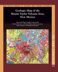
— Fraser Goff, Shari A. Kelley, Cathy J. Goff, David J. McCraw, G. Robert Osburn, John R. Lawrence, Paul G. Drakos, and Steven J. Skotnicki, 2019
The Geologic Map of the Mount Taylor Volcano Area, New Mexico is a 1:36,000 compilation of six recent NMBGMR 1:24,000 geologic quadrangles that encompass this extinct composite stratovolcano. Mount Taylor is New Mexico’s second-largest volcano after the Valles Caldera in the Jemez Mountains. This timely map and accompanying report, resulting from over a decade of thorough work, synthesizes the current geologic understanding of such an important landscape feature of the state.
For such a complex volcanic landform, the report provides an exhaustive description of the volcano area in an easy-to-read format. In addition to providing a detailed description of each of the map’s 339 units and dikes, it documents the volcano’s history and history of research, its geochemical and petrographic composition, the phases of its construction ranging from the initial to the terminal eruptions, 3.72–1.26 million years ago, and its subsequent erosion, resulting in the summit Amphitheater and its extensive apron of debris. It describes the surrounding volcanic centers, the structure of the area, and the extensive dikes and maars. After touching on the water resources, hydrothermal alteration and mineralization, and geothermal potential, the report concludes with a conceptual model of volcano evolution.
Available folded or rolled on field-durable media. There is also a puzzle version of this geologic map.
66 pages
ISBN: 978-1-883905-44-6
https://doi.org/10.58799/GM-80
$24.95
Buy
Now
more details...
One 62" x 44" folded sheet + 66 page booklet
Socks with Valles Caldera geologic map

— McGovern, 2021
Are you looking for the perfect New Mexico-themed gift to give your favorite geologist (even if that geologist is you)? If so, check out these sizzling socks, featuring a map of the Valles Caldera! The caldera formed during two volcanic super-eruptions that took place 1.6 and 1.2 million years ago and were so powerful that erupted ash is found in Kansas, Utah and Wyoming!
,
$26.45
Buy
Now
This price includes $7.50 extra shipping.
The Rio Chama: A River Guide to the Geology and Landscapes
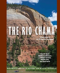
— Paul W. Bauer, Matthew Zimmerer, J. Michael Timmons, Brigitte Felix, and Steve Harris, 2021
The 135-mile Rio Chama of northern New Mexico is a major tributary of the Rio Grande. From its alpine headwaters at the Continental Divide of the glaciated San Juan Mountains in southern Colorado, this hidden gem flows across the Colorado Plateau in a spectacular canyon cut into Mesozoic sedimentary rocks, in places up to 1,500 feet deep. Towering, vibrant, sandstone cliffs, heavily wooded side canyons, superb camping, and a diversity of historical sites offer an outstanding wild river backdrop for the boater, angler, hiker, or camper.
This book contains detailed river maps of the seven sections of the Rio Chama, plus its three resplendent reservoirs, from the Colorado headwaters to its confluence with the Rio Grande near Española. The Chama Canyon section, below El Vado Dam and through the Chama Canyon Wilderness, is one of the finest, multi-day, whitewater trips in the Southwest.
134 pages
ISBN: 978-1-883905-32-3
$18.95
Buy
Now
more details...
Special Publication-15 — A History of the Geology Program at New Mexico State University: 1890 to 2015
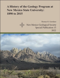
— Thomas H. Giordano, 2022
The history behind the Department of Geological Sciences at New Mexico State University goes back one hundred and thirty years and is complex. This history, as told in the pages of this monograph, documents the important details behind the founding of the NMSU geology program and its growth and evolution to 2015. The program's history is conveniently divided into three administrative phases. Phase I comprises the first 55 years, during which the program's activities were managed by one or two regular academic departments of the University. In the Earth Sciences phase, the geology program was administered as a division, along with one or two other divisions in the same department. In its third phase, the geology program became a regular academic department within the College of Arts and Sciences, its current status as the Department of Geological Sciences. Two obvious legacies of NMSU's geology program are the Department of Geological Sciences and the geophysics program in the Department of Physics. However, the program's legacy is also reflected in the students who have taken its courses and the program's research output through the efforts of its faculty, graduate students, and undergraduate students. Since the mid-1960s, the geology program has produced a vast amount of research that has led to a sophisticated understanding of the geology of southern New Mexico and adjacent areas. Finally, through a better understanding of the geology program's academic evolution, the program's alumni and current students, faculty, and staff will have a more profound appreciation of their academic experience at New Mexico State University
Note:
This publication can be downloaded for free or can be purchased as an on-demand printed book.
NMGS, 45 pages
ISBN: 1-58546-114-8
https://doi.org/10.56577/SP-15
Softcover:
$20.00
Buy
Now
more details...
Satellite mug
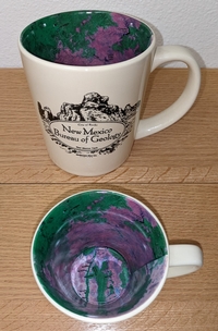
The interior of this mug has a reproduction of our Resource Map-23: Satellite Image of New Mexico. The front of the mug says "New Mexic Bureau of Geology" with a graphic depicting City of Rocks State Park near Deming, New Mexico.
$14.99
Buy
Now
Mount Taylor Puzzle
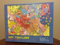
— Fraser Goff, Shari A. Kelley, Cathy J. Goff, David J. McCraw, G. Robert Osbourn, John R. Lawrence, Paul G. Drakos, and Steven J. Skotnicki, 2018
This vibrant 19 x 27" 1000 piece puzzle version of our Geologic Map of Mount Taylor will keep you from finishing that geochemistry paper you should be writing.
$19.95
Buy
Now
calendar- — 2024 Calendar
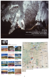
— NMBGMR, 2024
This calendar highlights photographs from the fine amateur photographers on staff at the New Mexico Bureau of Geology. We hold an annual internal contest, and the winning images are used for our calendar. These images were taken throughout the state, and most are geologically themed.
$10.00
Buy
Now
Note: availability of this publication
is limited!
NM Bureau of Geology Mineral Museum Gray Adjustable Souvenir Hat
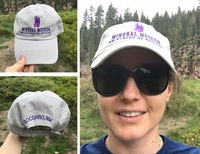
— New Mexico Bureau of Geology and Mineral Resources, 2019
Look great and support the New Mexico Bureau of Geology's Mineral Museum with this fun, stylish hat! Order yours today! *FREE SHIPPING*-LIMITED TIME ONLY! Cart will indicate shipping but you will not be charged!
$29.95
Buy
Now
Adjustable gray cap with purple embroidered front and back lettering and image.
Geologic Road Log: Cumbres & Toltec Scenic Railroad
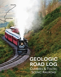
— Shari Kelly, Peter Barkmann, Rob Benson, Jonathan Lovekin, and Lisa Dunn, 2023
This geologic road log describes the diverse geology exposed along the Cumbres & Toltec Scenic Railroad between Antonito, Colorado, and Chama, New Mexico. The booklet was designed for use on the annual "Geotrain" excursion offered by the Cumbres & Toltec Scenic Railroad each summer since 2011. The geologic journey begins in the San Luis Basin in the Rio Grande rift, traverses the southern San Juan volcanic field, and ends in the Chama Basin. The booklet includes a brief introduction to the regional geology of the area, a discussion of the engineering geology associated with building and maintaining the railroad, and descriptions of outcrops exposed in roadcuts along the rail line.
36 pages
ISBN: 978-1-883905-51-4
$9.00
Buy
Now
more details...
Lanyards Various Colors
Clip one of these lanyards to your hand lens and sling it around your neck for your next adventure in the field. Various colors are available, so specify in the comments which color choices you prefer. We'll send you a random color otherwise.
$7.00
Buy
Now