


GM-44 — Geology of West Half Corralitos Ranch Quadrangle, New Mexico
We are a research and service division of:
By Russell E. Clemons, 1977, 2 sheets, scale 1:24,000.
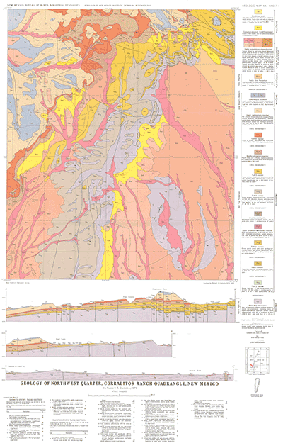
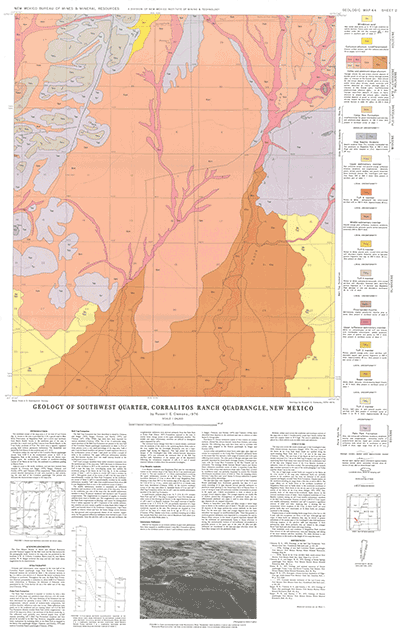
These two sheets are part of a continuing program of geologic investigations of the Rio Grande trough and adjacent uplifts between Hatch and Las Cruces. They were preceeded by two adjacent map sheets published as GM-36.
Note: The latitude coordinates on the south end of Sheet 1 are incorrect, they should read 32°22'30".
$7.00
Buy
Now
Also available as a free download.
Download
| File Name | Size | Last Modified |
|---|---|---|
| GM-44_complete.zip | 13.05 MB | 02/05/2021 03:25:07 PM |
| GM-44_map_sheet1.pdf | 6.76 MB | 02/05/2021 03:24:10 PM |
| GM-44_map_sheet2.pdf | 6.76 MB | 02/05/2021 03:24:52 PM |
| GISdata: | ||
| GeMSVariationRedaMe.txt | 1 KB | 07/31/2019 12:31:59 PM |
| MagdalenaGap_GM44Plate2.mpk | 2.52 MB | 07/08/2019 01:54:17 PM |
| MagdalenaPeak_GM44Plate1.mpk | 3.62 MB | 07/08/2019 02:05:15 PM |
| TIFF: | ||
| GM-44_map_sheet1-pal.tif | 18.86 MB | 09/12/2018 02:59:05 PM |
| GM-44_map_sheet1.tif | 127.34 MB | 09/12/2018 02:56:32 PM |
| GM-44_map_sheet2-pal.tif | 17.44 MB | 09/12/2018 03:05:24 PM |
| GM-44_map_sheet2.tif | 124.26 MB | 09/12/2018 03:03:56 PM |