


Aquifer Mapping and Monitoring Program (AMMP)
The Aquifer Mapping and Monitoring Program (AMMP) collects and interprets earth science data in order to map, characterize, and monitor the state’s groundwater resources. By providing this information, AMMP empowers New Mexicans to make informed water management and planning decisions.
The Aquifer Mapping and Monitoring Program (AMMP) is a growing division of the New Mexico Bureau of Geology and Mineral Resources. Our program, which officially began in 2006, is working to map and characterize New Mexico’s aquifers by providing information on hydrogeology, depth to water, groundwater flow directions, recharge processes, and water quality characteristics.
Funding for AMMP is historically a mixture of a base budget from the Bureau, grants and contracts with state, federal, or local agencies, and philanthropic support. Strong legislative support in 2024 and 2025 has increased the Program’s base budget, enabling AMMP to take a proactive step in securing New Mexico’s water future by developing a statewide initiative focused on understanding and monitoring the state’s groundwater resources. Key pieces of this program are highlighted below.

Geophysical Surveys
New data collection for mapping aquifers started in fall 2025, which includes collecting geophysical data, including low-altitude airborne electromagnetic (AEM) surveys across the state. These helicopter-based surveys will measure the electromagnetic response of geologic materials such as sand, gravel, and clay. The focus is on conducting regional and sub-regional scale geophysical surveys to identify, characterize, and classify geologic structures, aquifer extents, depth to bedrock, and depth to fresh and brackish water. The first phase of these projects will focus on the planning, acquisition, and interpretation of geophysical data for a region. The data collected through these geophysical surveys and additional geological studies will support the development of regional-scale characterizations of fresh and brackish water in alluvial basins across parts of selected groundwater basins. For more information about AEM surveys work and where we are mapping, please see our project page — Airborne Geophysical Survey Project.
Groundwater Monitoring
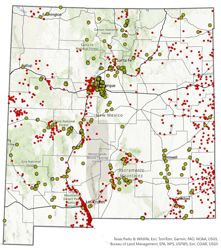
Groundwater is a vital resource for New Mexico’s communities, agriculture, and ecosystems, and unlocking its full potential requires reliable data. By mapping aquifers and establishing a long-term monitoring network, the program generates essential insights into how groundwater moves, where it’s stored, and how it changes over time. Through the ongoing philanthropic support of the Healy Foundation, AMMP created the Collaborative Groundwater Monitoring Network. This network provides critical, baseline information on groundwater trends through collaborative data collection and regular measurements of depth to water across the state. State funding will enable this program to drill new monitoring wells in strategic locations, addressing questions about water quality, water depth, and filling critical gaps in subsurface knowledge.
View our Aquifer Mapping Program Brochure for more information on current projects.
Contact Us
Laila Sturgis — Aquifer Mapping Program Manager, (575) 835-5327