


Types of Geologic Maps
We are a research and service division of:
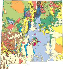
- Statewide Geologic Maps of New Mexico:
- The 1:500,000 Geologic Map of New Mexico provides a great overview of the geology of our state.
- The Geologic Highway Map of New Mexico (1:1,000,000) is perfect for the glove compartment or the saddle bag.
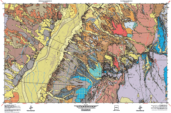
- Geologic maps of 7.5-minute quadrangles (1:24,000 scale):
- Geologic mapping at the standard 1:24,000 scale (1” = 2000’) is a staple of geologic map datasets in New Mexico. For available 1:24,000 scale mapping see our index of quadrangle mapping in New Mexico or the Open File Geologic Map Series home page.
- Our GM-series geologic maps are a series of high-quality map products . Our open-filed products will migrate to this series following rigorous review and cartographic production.
- Our Open File Geologic Map series was created to accommodate our participation in the STATEMAP Program allowing us to quickly disseminate geologic maps. The series has a range of map products, from preliminary hand-drafted maps to fully edited, reviewed and cartographically complete map products, comparable to our GM map series. This series represents the latest geologic field work and basic research that are primary sources of geoscience information for our staff and other geoscientists throughout the state.
- Geologic maps in Bulletins, Circulars, Memoirs and Open-File Reports.
- Geologic Map compilations of other scales:
- For some areas, researchers have compiled geologic map data to create a new geologic map compilation to address basin-scale, mountain-block scale or regional scale geologic maps. This synthesis is usually done to address some pressing need for understanding a broader context of an area. These maps are found in a number of different map series including: Bulletins, Circulars, Memoirs, GM series and Open File Reports .
- Most USGS geologic maps of New Mexico are available from our publications office (contact us to see if a map you need is in stock). You also may be interested in some of the NM-specific USGS map products available via the USGS National Geologic Map Database.
- Open File Geologic Maps (OFGM-series) are products from our STATEMAP Program. The geologic field work and basic research are a primary source of geoscience information for our staff and other geoscientists throughout the region (see our index of STATEMAP open-filed geologic maps).
- Our GM-series geologic maps are high-quality offset-printed paper maps. Our open-filed products will migrate to this series following rigorous review and cartographic production.
- We carry most geologic maps of New Mexico published by the USGS. Please visit or call us to see if the map you're interested in is in stock.
But how do I find what I'm looking for?
Searching for geologic maps that cover a given area can be complicated because maps may cover unpredicable areas (e.g. quadrangles, counties, study areas, etc.) and be at various scales. Aside from our statewide maps, most of our maps are of 7.5 minute quadrangles (search by name). Another way to locate maps is to use either our Interactive Map Portal or the USGS National Geologic Map Database which catalogs maps in various searchable ways.