


Recent Publications
We are a research and service division of:
The New Mexico Bureau of Geology and Mineral Resources has published geoscience research and information since its inception in 1927. Our publishing program serves both the professional geologic community and the general public. Many of our publications are now offered in electronic format, and most of those are available for free download. However, many of our older publications and selected newer publications are available in print.
We also carry publications from the New Mexico Geological Society (NMGS), United States Geological Survey (USGS), as well as other publishers.
Below is a selection of the more recent publications we have available:
calendar- — 2024 Calendar
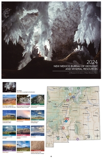
— NMBGMR, 2024
This calendar highlights photographs from the fine amateur photographers on staff at the New Mexico Bureau of Geology. We hold an annual internal contest, and the winning images are used for our calendar. These images were taken throughout the state, and most are geologically themed.
$10.00
Buy
Now
Note: availability of this publication
is limited!
Open-file Report-625 — Winter 2021–2022 Water-Level Elevation Map for the Albuquerque Metropolitan Area
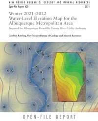
— Geoffrey Rawling, 2023
The residents of the Albuquerque metropolitan area rely in part on groundwater for domestic, municipal, and industrial use. An understanding of changes in groundwater levels and groundwater storage in the aquifer is necessary to achieve groundwater management goals set by the Albuquerque Bernalillo County Water Utility Authority. Periodic and continuous water-level measurements in wells and maps of the water-level elevation surface, or water table, derived from these data are essential tools for understanding the groundwater resources of the region.
This report describes the preparation and interpretation of a water-table map for the Albuquerque area for the winter of 2021–2022. Water-level changes and changes in the amount of groundwater in storage in the aquifer since the predevelopment time period are presented. The present study also recasts recent water-level surface and changes since predevelopment in terms of water-level management criteria defined by the Water Authority.
18 pages
https://doi.org/10.58799/OFR-625
$10.00
Buy
Now
more details...
Also available as a free download.
Geologic Road Log: Cumbres & Toltec Scenic Railroad
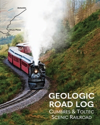
— Shari Kelly, Peter Barkmann, Rob Benson, Jonathan Lovekin, and Lisa Dunn, 2023
This geologic road log describes the diverse geology exposed along the Cumbres & Toltec Scenic Railroad between Antonito, Colorado, and Chama, New Mexico. The booklet was designed for use on the annual "Geotrain" excursion offered by the Cumbres & Toltec Scenic Railroad each summer since 2011. The geologic journey begins in the San Luis Basin in the Rio Grande rift, traverses the southern San Juan volcanic field, and ends in the Chama Basin. The booklet includes a brief introduction to the regional geology of the area, a discussion of the engineering geology associated with building and maintaining the railroad, and descriptions of outcrops exposed in roadcuts along the rail line.
36 pages
ISBN: 978-1-883905-51-4
$9.00
Buy
Now
more details...
Guidebook-73 — Evaporite Karst of the Lower Pecos Region
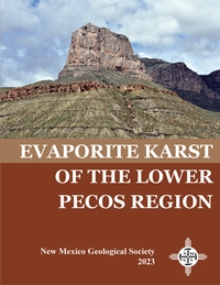
— Lewis Land, Issam Bou Jaoude, Peter Hutchinson, Kate Zeigler, Anne Jakle, and Brittney Van Der Werff, [eds.], 2023
Mirror Lake, one of seven sinkhole lakes, or cenotes, in Bottomless Lakes State Park, is located at the downgradient end of the regional hydrologic system in the Roswell Artesian Basin. Recharge to the artesian aquifer occurs on the Pecos Slope west of Roswell by direct infiltration from precipitation and by runoff from intermittent losing streams flowing eastward across the San Andres limestone outcrop. Groundwater flows east and south, then upward through leaky overlying gypsum confining beds of the Seven Rivers Formation in the Pecos River Valley, where the potentiometric surface in the artesian aquifer is above ground level. Dissolution of gypsum beds caused by this upward artesian flow created and continues to enlarge the cenotes along the Seven Rivers Escarpment. Overflow from Lea Lake, the southernmost and largest of the Bottomless Lakes sinkholes, amounts to roughly 15,000 acre-ft/yr and has caused an expansion of wetlands to the west, which are now hydraulically connected to the Pecos River, resulting in a net gain in streamflow and an increase in salinity in the river downstream from the park.
The gentle eastward regional dip of the area is locally reversed along the escarpment, where strata of the Seven Rivers Formation dip abruptly southwest by as much as 40°. This local dip reversal, clearly visible in the walls of Mirror Lake, is probably not tectonic but the result of subsurface dissolution of gypsum by ascending artesian groundwater and consequent slumping of overlying beds.
There are two versions of this guidebook available, the complete guidebook (152 pages), and a version with just the road logs that is spiral bound (76 pages).
NMGS, 152 pages
ISBN: 1-58546-117-2
https://doi.org/10.56577/FFC-73
Softcover:
$65.00
Buy
Now
more details...
Individual papers from this guidebook are available as free downloads from the NMGS site.
Bulletin-165 — Quaternary and Archaeological Geology of the Mescalero Plain, Southeastern New Mexico
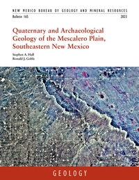
— Stephen A. Hall and Ronald J. Goble, 2023
This bulletin synthesizes 177 optically stimulated luminescence (OSL) and 54 radiocarbon dates, as well as detailed sediment size and chemical signature data, to document the history of eolian sand deposition during the late Pleistocene and Holocene in southeastern New Mexico. The authors use this history, which is based on 20 years of field observations, to assess the preservation potential of archeological sites in this area. The bulletin is richly illustrated with photographs and figures that clearly tell the story of unearthing discoveries that were previously hidden beneath the shifting sands of southeastern New Mexico.
216 pages
https://doi.org/10.58799/B-165
$10.00
Buy
Now
more details...
Also available as a free download.
Open-file Report-620 — Study to Address Erosion and Sedimentation in the Cañon Largo Watershed on the Jicarilla Apache Nation, Rio Arriba and Sandoval Counties, New Mexico
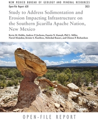
— Kevin M. Hobbs, Kristin S. Pearthree, Andrew P. Jochems, Phil L. Miller, and Faustin N. Kumah, 2023
This report gives a detailed treatment of the geological, hydrological, and engineering factors affecting erosion and sedimentation in the upper Cañon Largo watershed on the southern Jicarilla Apache Nation, New Mexico. We summarize previous studies of geology and hydrology and provide new detail on stream dynamics, sediment transport, and rates of erosion and sedimentation.
Two new maps are complements to and were produced concurrently with this report: the Geologic Map of the Cañon Largo Watershed on the Jicarilla Apache Nation, Rio Arriba and Sandoval Counties, New Mexico, which presents detailed surficial geologic mapping and descriptions at the 1:50,000 scale, and the Erosion and Sedimentation Hazard Map of the Cañon Largo Watershed on the Jicarilla Apache Nation, Rio Arriba and Sandoval Counties, New Mexico, which displays the computed level of risks associated with the potential for an erosion or sedimentation event, also at the 1:50,000 scale. Each of these maps has its own associated report.
https://doi.org/10.58799/OFR-620
$10.00
Buy
Now
more details...
Also see related maps in sub-volumes (A and B).
Also available as a free download.
2022 Fort Stanton Cave Science Conference Road Log & Field Guide
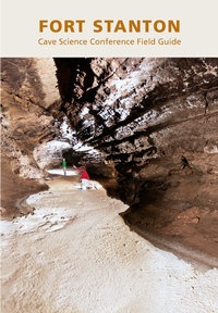
— Steve Peerman, Johanna Blake, Christina Ferguson, Penny Boston, Cynthia Connolly, Keely Miltenberger, Talon Newton, and Mike Spilde, 2022
This free geologic road log and field guide describes the geology in and around Fort Stanton Cave in New Mexico. The guide was prepared for the 2022 Fort Stanton Cave Science Conference Field Trip, which was part of the New Mexico Geological Society Annual Spring Meeting & Ft. Stanton Cave Conference, April 7-9, 2022, Macey Center, Socorro, NM.
More information on the history of the Fort Stanton–Snowy River Cave, including photos, can be found on the Fort Stanton Cave Study Project (FSCSP) website. Information on the history of the Fort Stanton–Snowy River National Conservation Area can be found on the U.S. Bureau of Land Management website.
Suggested citation:
Peerman, Steve; Blake, Johanna; Ferguson, Christina; Boston, Penny; Connolly, Cynthia; Miltenberger, Keely; Newton, Talon; Spilde, Mike; 2022, Fort Stanton Cave Science Conference Road Log & Field Guide, for: New Mexico Geological Society Annual Spring Meeting & Ft. Stanton Cave Conference, April 7-9, 2022, Macey Center, Socorro, NM, New Mexico Bureau of Geology and Mineral Resources, 31p.
31 pages
Available as a free download.
Bulletin-164 — Climate Change in New Mexico Over the Next 50 Years: Impacts on Water Resources
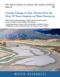
— N.W. Dunbar, D.S. Gutzler, K.S. Pearthree, F.M. Phillips, P.W. Bauer, C.D. Allen, D. DuBois, M.D. Harvey, J.P. King, L.D. McFadden, B.M. Thomson, and A.C. Tillery, 2022
Earth is warming in response to increasing atmospheric carbon dioxide. Global climate models project an average temperature increase across New Mexico of 5° to 7° F over the next 50 years. Other primary impacts are decreased water supply (partly driven by thinner snowpacks and earlier spring melting), lower soil moisture levels, increased frequency and intensity of wildfires, and increased competition and demand for scarce water resources. Snowpack and associated runoff are projected to decline substantially over the next 50 years, generating diminished headwater streamflow. Flow in the state's major rivers is projected to decline by 16% to 28%, and the frequency of extreme precipitation events, coupled with fire-driven disruption of vegetation in watersheds, is projected to at least double river sediment. The impacts of climate change on New Mexico's water resources are overwhelmingly negative.
The bulletin, which is the scientific foundation upon which New Mexico's 50-Year Water Plan is based, represents a compilation, assessment and integration of existing peer-reviewed published research, technical reports and datasets relevant to the broad topic of changes to New Mexico climate over the next 50 years, and resultant impact on water resources. This project, also known as the "Leap Ahead" analysis, also identifies significant data and modeling gaps and uncertainties, and suggests research directions to strengthen our understanding of climate and water resource changes
218 pages
https://doi.org/10.58799/B-164
$10.00
Buy
Now
more details...
Also available as a free download.
Lanyards Various Colors
Clip one of these lanyards to your hand lens and sling it around your neck for your next adventure in the field. Various colors are available, so specify in the comments which color choices you prefer. We'll send you a random color otherwise.
$7.00
Buy
Now
Open-file Report-618 — Hydrogeology and water resources of the Salt Basin, New Mexico and Texas
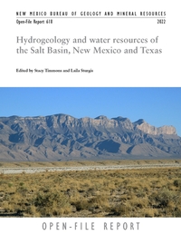
— Stacy Timmons and Laila Sturgis, [eds.], 2022
INTRODUCTION
The Salt Basin is a hydrologically closed, semiarid basin shared across the southern region of New Mexico and westernmost Texas (Figure TS-1). Water resources in the southwestern United States are limited, and they are becoming further strained due to increasing aridity and rising temperatures in the face of climate change. Even with significant changes to current water use and robust conservation, exploration of new or alternative water resources may be necessary as water shortages occur in the Southwest. Historically, in New Mexico water resource exploration efforts have occurred in basins with limited groundwater pumping or population. The Salt Basin has been one such region of exploratory interest for several decades.
The process of determining a firm water budget in this region has long eluded and challenged researchers and consultants. Data density in some areas is too sparse to draw reliable conclusions, especially with regard to the subsurface. One of the biggest obstacles to fully quantifying the water resources in the region is simply its remoteness and isolation, in addition to limited data availability and groundwater access.
PURPOSE AND SCOPE OF THIS PROJECT
Beginning in 2019, the New Mexico Bureau of Geology and Mineral Resources (NMBGMR) and the New Mexico Institute of Mining and Technology (NMT) initiated research to assess the water resources of the Salt Basin region of southern New Mexico and westernmost Texas. This project was funded by the U.S. Bureau of Reclamation and was conducted in coordination with two graduate students at NMT, the U.S. Geological Survey (USGS), the New Mexico Interstate Stream Commission (NMISC), and consultants with the NMISC. The current study was initiated as a result of NMISC considering potential groundwater export from the New Mexico portion of the basin to other regions of New Mexico, particularly during times of reduced surface water availability.
The purpose of this project was to assess the water resources and evaluate the sustainability of pumping 100,000 acre-ft/yr in the Salt Basin region. In particular, the project’s scope addressed the Salt Basin regional water availability by (1) identifying and attempting to address data gaps where there is currently little or no information about the groundwater system; (2) refining estimates of the regional water budget, including groundwater recharge, storage, evapotranspiration, and pumping; (3) building and updating the hydrogeologic framework and numerical hydrologic model; and (4) running specific pumping scenarios in the revised model. These efforts focus attention on the region’s capacity to sustain current groundwater withdrawals in the Salt Basin and implications for future development in New Mexico. Additional techniques applied in this study included electromagnetic geophysical measurements to better characterize the subsurface of the Salt Basin and to evaluate use of these methods in identifying saline or brackish aquifers.
In the first year of this study, the research team compiled previous data and reports to build the data release report NMBGMR Open File Report 608 (Kelley et al., 2020). Kelley et al. (2020) included an overview of the Salt Basin geology, a description of the geophysical and geochemical studies completed by others, a review of the previous estimates for recharge, and discussion of the existing hydrologic models of the region. From this data summary, in the second year of this study, data gaps were identified and efforts were taken to fill them. The research team collected 13 new water chemistry samples, inventoried 20 wells in New Mexico, conducted geophysical surveys, and applied new recharge estimations, along with estimating groundwater storage and water use. Two student master’s theses were completed on portions of this research. This report is the final summary and synthesis of the work completed.
144 pages, 4 appendices
https://doi.org/10.58799/OFR-618
$10.00
Buy
Now
more details...
Also available as a free download.
Guidebook-72 — Socorro Region III
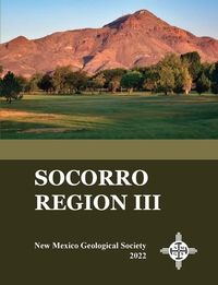
— Daniel J. Koning, Kevin J. Hobbs, Fred M. Phillips, W. John Nelson, Steven M. Cather, Anne C. Jakle, and Brittney Van Der Werff, 2022
Beautifully exposed geologic features in the Socorro region exemplify important events in the geologic history of central New Mexico. The relative ease of access to these intriguing features from the town of Socorro justifies a third NMGS visit to this area. The 2022 Fall Field Conference will showcase new mapping, geochronology, and other geologic studies that have occurred in the Socorro region since the 1983 Fall Field Conference. The array of rocks seen here include Proterozoic crystalline rocks, a relatively complete Pennsylvanian-Permian section, Oligocene volcanic rocks, Santa Fe Group deposits from all phases of rifting, and a complete set of post–Santa Fe Group, Quaternary terraces. Fault-propagation and fault-bend folds associated with the Laramide orogeny, in addition to rift-related domino-block tilting and half-grabens, are also nicely exposed in the Socorro area. This volume includes detailed road logs of the Socorro area, including the Little San Pascual Mountains. Twenty-one peer-reviewed, technical papers and seven minipapers present recent research of this important region.
There are two versions of this guidebook available, the complete guidebook (426 pages), and a version with just the road logs that is spiral bound (146 pages).
NMGS, 426 pages
ISBN: 1-58546-115-6
https://doi.org/10.56577/FFC-72
Softcover:
$65.00
Buy
Now
more details...
Individual papers from this guidebook are available as free downloads from the NMGS site.
Special Publication-15 — A History of the Geology Program at New Mexico State University: 1890 to 2015
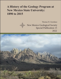
— Thomas H. Giordano, 2022
The history behind the Department of Geological Sciences at New Mexico State University goes back one hundred and thirty years and is complex. This history, as told in the pages of this monograph, documents the important details behind the founding of the NMSU geology program and its growth and evolution to 2015. The program's history is conveniently divided into three administrative phases. Phase I comprises the first 55 years, during which the program's activities were managed by one or two regular academic departments of the University. In the Earth Sciences phase, the geology program was administered as a division, along with one or two other divisions in the same department. In its third phase, the geology program became a regular academic department within the College of Arts and Sciences, its current status as the Department of Geological Sciences. Two obvious legacies of NMSU's geology program are the Department of Geological Sciences and the geophysics program in the Department of Physics. However, the program's legacy is also reflected in the students who have taken its courses and the program's research output through the efforts of its faculty, graduate students, and undergraduate students. Since the mid-1960s, the geology program has produced a vast amount of research that has led to a sophisticated understanding of the geology of southern New Mexico and adjacent areas. Finally, through a better understanding of the geology program's academic evolution, the program's alumni and current students, faculty, and staff will have a more profound appreciation of their academic experience at New Mexico State University
Note:
This publication can be downloaded for free or can be purchased as an on-demand printed book.
NMGS, 45 pages
ISBN: 1-58546-114-8
https://doi.org/10.56577/SP-15
Softcover:
$20.00
Buy
Now
more details...
Socks with Valles Caldera geologic map

— McGovern, 2021
Are you looking for the perfect New Mexico-themed gift to give your favorite geologist (even if that geologist is you)? If so, check out these sizzling socks, featuring a map of the Valles Caldera! The caldera formed during two volcanic super-eruptions that took place 1.6 and 1.2 million years ago and were so powerful that erupted ash is found in Kansas, Utah and Wyoming!
,
$26.45
Buy
Now
This price includes $7.50 extra shipping.
The Rio Chama: A River Guide to the Geology and Landscapes
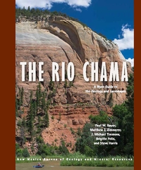
— Paul W. Bauer, Matthew Zimmerer, J. Michael Timmons, Brigitte Felix, and Steve Harris, 2021
The 135-mile Rio Chama of northern New Mexico is a major tributary of the Rio Grande. From its alpine headwaters at the Continental Divide of the glaciated San Juan Mountains in southern Colorado, this hidden gem flows across the Colorado Plateau in a spectacular canyon cut into Mesozoic sedimentary rocks, in places up to 1,500 feet deep. Towering, vibrant, sandstone cliffs, heavily wooded side canyons, superb camping, and a diversity of historical sites offer an outstanding wild river backdrop for the boater, angler, hiker, or camper.
This book contains detailed river maps of the seven sections of the Rio Chama, plus its three resplendent reservoirs, from the Colorado headwaters to its confluence with the Rio Grande near Española. The Chama Canyon section, below El Vado Dam and through the Chama Canyon Wilderness, is one of the finest, multi-day, whitewater trips in the Southwest.
134 pages
ISBN: 978-1-883905-32-3
$18.95
Buy
Now
more details...
The Geology of Southern NM Parks, Monuments, and Public Lands
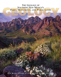
— Peter A. Scholle, Dana S. Ulmer-Scholle, Steven M. Cather, and Shari A. Kelley, [eds.], 2020
Southern New Mexico has a wonderful combination of spectacular scenery and a sparse population. The state’s diverse and interesting geology is reflected in its numerous National and State parks and monuments (including Carlsbad Caverns and White Sands) as well as other publicly accessible lands, which range in size from the multi-million acre Gila wilderness to small roadside turnoffs and picnic areas. This book, crafted by geoscientists but written for the interested public, provides an understanding of the exposed rock units that record more than 1.7 billion years of geologic and biologic changes in this region. With nearly 400 full-color photographs, geologic maps, and illustrations, this book illuminates not just the rocks and fossils of southern New Mexico, but also archaeological/historical sites as well as the water, mineral, and energy resources of the region.
Free sample chapter — White Sands
404 pages
ISBN: 978-1-883905-48-4
$29.95
Buy
Now
more details...
The Rio Grande: A River Guide to the Geology and Landscapes of Northern New Mexico
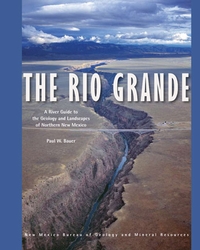
— Paul W. Bauer, 2011
The Rio Grande is the fourth longest river in North America. Flowing nearly 2,000 miles from Colorado to the Gulf of Mexico, in New Mexico it occupies the Rio Grande Valley, where it provides water for habitat, agriculture, and a growing population. In northern New Mexico, where the river has carved a pair of spectacular canyons, the Rio Grande also provides some of the most exceptional recreation opportunities and scenery in North America. This comprehensive, spiral bound, river-friendly, 122-page river guide provides detailed, full-color maps of 153 miles of the Rio Grande, from Lasauses, Colorado to Cochiti Dam in New Mexico. Divided into eleven river stretches—including the popular whitewater runs in the Taos Box, Racecourse, and White Rock Canyon—the guide covers stretches that range in difficulty from placid canoe tours to gripping kayak descents. The river maps are developed on an aerial photographic base (digital orthophoto quads), allowing the user to more easily identify locations.
Minor updates were made to text and figures for reprinting in 2022.
120 pages
ISBN: 978-1-883905-28-6
$23.00
Buy
Now
more details...
Mount Taylor Lava Flow Earrings
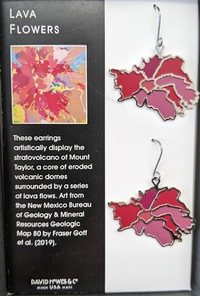
Produced by David Howell & Co., these earrings are a simplified depiction of lava flows shown on our Geologic Map of Mount Taylor, which look a bit like flowers.
$20.95
Buy
Now