


River Guides
We are a research and service division of:
We have published two guides to popular New Mexico rivers. Both guides contain full-color river maps, and detailed geologic, hydrologic, and historical information. Both guides are printed on waterproof paper and will be of interest whitewater enthusiasts, anglers, hikers, campers, and anyone else who spends time on these rivers.
The Rio Chama: A River Guide to the Geology and Landscapes
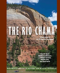
By: Paul W. Bauer, Matthew Zimmerer, J. Michael Timmons, Brigitte Felix, and Steve Harris, 2021
The 135-mile Rio Chama of northern New Mexico is a major tributary of the Rio Grande. From its alpine headwaters at the Continental Divide of the glaciated San Juan Mountains in southern Colorado, this hidden gem flows across the Colorado Plateau in a spectacular canyon cut into Mesozoic sedimentary rocks, in places up to 1,500 feet deep. Towering, vibrant, sandstone cliffs, heavily wooded side canyons, superb camping, and a diversity of historical sites offer an outstanding wild river backdrop for the boater, angler, hiker, or camper.
This book contains detailed river maps of the seven sections of the Rio Chama, plus its three resplendent reservoirs, from the Colorado headwaters to its confluence with the Rio Grande near Española. The Chama Canyon section, below El Vado Dam and through the Chama Canyon Wilderness, is one of the finest, multi-day, whitewater trips in the Southwest.
134 pages
ISBN: 978-1-883905-32-3
$18.95
Buy
Now more details...
The Rio Grande: A River Guide to the Geology and Landscapes of Northern New Mexico
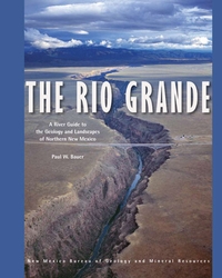
By: Paul W. Bauer, 2011 (reprinted: 2022)
The Rio Grande is the fourth longest river in North America. Flowing nearly 2,000 miles from Colorado to the Gulf of Mexico, in New Mexico it occupies the Rio Grande Valley, where it provides water for habitat, agriculture, and a growing population. In northern New Mexico, where the river has carved a pair of spectacular canyons, the Rio Grande also provides some of the most exceptional recreation opportunities and scenery in North America. This comprehensive, spiral bound, river-friendly, 122-page river guide provides detailed, full-color maps of 153 miles of the Rio Grande, from Lasauses, Colorado to Cochiti Dam in New Mexico. Divided into eleven river stretches—including the popular whitewater runs in the Taos Box, Racecourse, and White Rock Canyon—the guide covers stretches that range in difficulty from placid canoe tours to gripping kayak descents. The river maps are developed on an aerial photographic base (digital orthophoto quads), allowing the user to more easily identify locations.
Minor updates were made to text and figures for reprinting in 2022.
120 pages
ISBN: 978-1-883905-28-6
$23.00
Buy
Now more details...