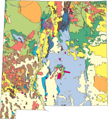
What are geologic maps and what are they used for?

Geologic maps are uniquely suited to solving problems involving Earth resources, hazards, and environments. Geologic maps represent the distribution of different types of rock and surficial deposits, as well as locations of geologic structures such as faults and folds. Geologic maps are the primary source of information for various aspects of land-use planning, including the siting of buildings and transportation systems. And perhaps most importantly for the people of New Mexico, such maps help identify ground-water aquifers, aid in locating water-supply wells, and assist in locating potential polluting operations, such as landfills, safely away from the aquifers.
Geologic maps are actually four-dimensional data systems, and it is the fourth dimension of time that is crucial to assessing natural hazards and environmental or socio-economic risk. To read a geologic map is to understand not only where materials and structures are located, but also how and when these features formed.
Digital geologic maps are interactive electronic documents that put earth science issues into geospatial frameworks. They capture the size, the shape, the depth, and the physical and chemical contexts of earth materials, and they blend data display with the results of interpretive research. The combination of geologic maps and GIS databases help us address a great variety of complex geologic and hydrologic issues, such as: How does subsurface distribution of porous and impermeable rock affect the flow of water, the potential for contamination, and the volume available for use?
Isn't New Mexico already mapped?
New Mexico contains nearly 2000 7.5-minute quadrangle maps, an area of 121,510 square miles. And yet only about 300 of those quads are available as geologic maps at the standard, scale of 1:24,000 (1 inch equals 2000 feet). Clearly, not all of New Mexico needs mapping at that scale. But, in the past, geologic mapping was not concentrated in the settled regions, such as along the Rio Grande and other major rivers. Instead, maps were made in mining districts and in areas of noteworthy scientific investigations. Recently, however, economic development and unprecedented growth of communities within the Rio Grande watershed have resulted in growing pressures to utilize our natural resources . It is critically important for communities and agencies to have access to modern and accurate scientific data concerning their environment. Much of the mapping that we undertake is directed toward providing such information.
How do I find what I'm looking for?
Searching for geologic or other maps that cover a given area can be complicated because maps may cover unpredicable areas (e.g. quadrangles, counties, study areas, etc.) and be at various scales. Aside from our statewide maps, most of our maps are of 7.5 minute quadrangles (search by name). Another way to locate maps is to use either our Interactive Map Portal or the USGS National Geologic Map Database which catalogs maps in various searchable ways.

