


Earthquakes in New Mexico
We are a research and service division of:
Thousands of faults are found in New Mexico but only a handful of them have ruptured in the geologically recent past, during the Quaternary Period or during the past 2,600,000 years. Quaternary faults are found throughout the western two-thirds of the state, but they are especially concentrated in the Rio Grande rift, a narrow belt of basins that bisect New Mexico and Colorado.
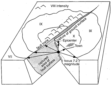
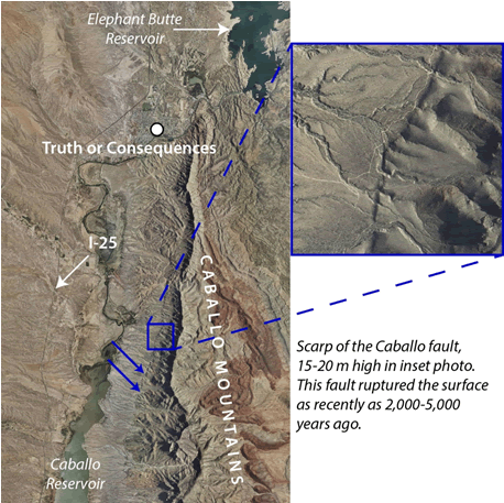
There are 162 Quaternary faults in New Mexico as shown in the Quaternary faults and folds database hosted by the U.S. Geological Survey. Of these, 20 are considered active based on evidence for surface-rupturing earthquakes within the last 15,000 years. Several of these could pose a risk to urban areas, such as the Hubbell Springs and Rincon faults near Albuquerque and the San Andres-Organ-East Franklin Mountains fault system near Las Cruces and El Paso.
Previous researchers have characterized the seismic hazard in the middle Rio Grande valley (from Santa Fe to Belen) as moderate compared to southern California and the Wasatch Front of Utah. Although rupture events along a single fault may not occur frequently, the large number of geologically young faults in central New Mexico increases the probability that an earthquake or earthquakes will occur in the region. Although the probability is moderate, the consequence of effects from such a quake is high.
Historic seismicity in New Mexico does not necessarily coincide with mapped Rio Grande rift faults. Many shocks are concentrated in the Socorro seismic anomaly that overlies a thin, horizontal body of magma located at a shallow depth (~19 km) in the crust. Two of the largest historic earthquakes in New Mexico, estimated at magnitudes of 5.76 and 6.18, occurred near Socorro in 1906.
The largest regional earthquake in historic records is the approximately 7.4-magnitude quake that ruptured the Pitaycachi fault in northeastern Sonora, Mexico in 1887. That event was felt as far away as Albuquerque and Santa Fe. Today, earthquakes of relatively low magnitude (≤3) occur all around the state, most barely or not at all perceptible to the average person.
While our understanding of Quaternary faults and seismicity in New Mexico has expanded greatly over the years, there is still much we don’t know. Much information from young faults comes from paleoseismic studies that involve digging trenches several meters deep across their profiles. Descriptions are made of faulting-related deposits, and sediment and/or charcoal samples are taken from those deposits that can be dated using techniques like luminescence or radiocarbon dating. Recurrence intervals, or the average amount of time between surface ruptures on a single fault, can then be estimated from the ages obtained. These types of studies will be essential for better characterizing the seismic hazard to population centers in New Mexico.
References
- Machette, M.N., Personius, S.F., Kelson, K.I., Haller, K.M., and Dart, R.L., 1998, Map and data for Quaternary faults and folds in New Mexico: U.S. Geological Survey Open-File Report 98-521, 443 p.
- Pearthree, P.A., Bull, W.B., and Wallace, T.C., 1990, Geomorphology and Quaternary geology of the Pitaycachi fault, northeastern Sonora, Mexico, in Gehrels, G.E., and Spencer, J.E., eds., Geological Excursions through the Sonoran Desert Region, Arizona and Sonora: Arizona Geological Survey Special Paper 7, p. 124-135.
- Pursley, J., Bilek, S.L., and Ruhl, C.J., 2013, Earthquake catalogs for New Mexico and bordering areas: 2005-2009: New Mexico Geology, v. 35, no. 1, p. 3-12.
- Sanford, A.R., 2008, New estimates of the magnitudes and locations for the strongest earthquakes in 1906-1907 Socorro, New Mexico, earthquake swarm: New Mexico Geology, v. 30, no. 4, p. 107-112.
- Sanford, A.R., and Lin, K-w., 1998, Strongest earthquakes in New Mexico—1860 to 1998: New Mexico Institute of Mining and Technology, Geophysics Open-File Report 87, 4 p.
- Sanford, A.R., Lin, K-w., Tsai, I., and Jaksha, L.H., 2002, Earthquake catalogs for New Mexico and bordering areas: 1869-1998: New Mexico Bureau of Mines and Mineral Resources Circular 210, 104 p.
- Sanford, A.R., Mayeau, T.M., Schlue, J.W., Aster, R.C., and Jaksha, L.H., 2006, Earthquake catalogs for New Mexico and bordering areas II: 1999-2004: New Mexico Geology, v. 28, no. 4, p. 99-109.
- Stover, C.W., Reagor, B.G., and Algermissen, S.T., 1988, Seismicity map of the state of New Mexico: U.S. Geological Survey Miscellaneous Field Studies Map MF-2035, 1:1,000,000 scale.
- Wong, I., Olig, S., Dober, M., Silva, W., Wright, D., Thomas, P., Gregor, N., Sanford, A., and Love, D., 2004, Earthquake scenario and probabilistic ground-shaking hazard maps for the Albuquerque-Belen-Santa Fe, New Mexico, corridor: New Mexico Geology, v. 26, no. 1, p. 3-33.