


What Decision Makers Should Know About Arroyos in New Mexico
We are a research and service division of:
by:
David W. Love, New Mexico Bureau of Geology & Mineral Resources; and
Allen Gellis, U.S. Geological Survey
Background
Arroyo is a Spanish term for stream, but in the Southwest the term is commonly applied to streambeds that are dry most of the time. Some geographers have tried to restrict arroyo to streambed shapes that are eroded narrow and deep as opposed to washes that are wide and shallow, but some streambeds alternate between the two shapes either from year to year or along their courses downstream. Streambeds with eroded vertical banks evoke negative reactions from most viewers, and arroyos are commonly seen as a symptom that something is wrong and that someone or something is to blame. The natural function of arroyos is complicated and depends on several independent and linked variables of landscape, climate, vegetation, and land use.
The primary reason streambeds exist is that water passes from higher in the drainage basin to the mouth of the drainage basin. Water moving downhill has energy to transport loose soil particles (sediment) and does work to do so. The size and shape of the streambed is a direct reflection of the amount of water (both quantity and duration of flow), the energy gradient, and the characteristics of the sediment along the stream channel as well as resistant features along the path, such as bedrock and vegetation. Arroyos tend to respond quickly to precipitation and have flashy flow—streamflow that rises to floodstage and wanes quickly.
Each one of these variables (such as runoff-water from rainfall) is complicated in its own natural behavior, and alterations in any one of the variables affect others in more than one way. For example, the amount of water a drainage basin processes during the year is related to the amount of precipitation and its fate across the landscape. Precipitation in New Mexico is extremely variable. It is measured in amount and duration (e.g. rainfall intensity). Intense thunderstorm rainfall may do more landscape work than melting snow, but may not aid the growth of vegetation. Vegetation depends on the amount, frequency, and sequence of precipitation as well as other landscape variables (bedrock, soils, and orientation of slopes). If vegetation is dense enough to slow overland flow downslope to the streambed, much flow may be trapped by the vegetation and seep into the ground, nurturing the vegetation. Soil is held in place. If vegetation is less dense, some flow reaches the channel and affects flow downstream. With less vegetation, runoff may increase and flow may increase downstream. If climate shifts to less precipitation, vegetation may die, affecting overland flow and flow within the channel. If soil is eroded from the hillslopes and overwhelms the ability of the channel to transport it, the channel becomes choked with sediment, and the slope in the channel may decrease, affecting the energy to transport sediment. Unsaturated loose sediment may absorb more water, reducing flow until a threshold is met, after which both water and sediment continue to move down gradient. Excess runoff leads to erosion and transport of sediment within the channels. That sediment may be redeposited downstream (such as in man-made reservoirs).
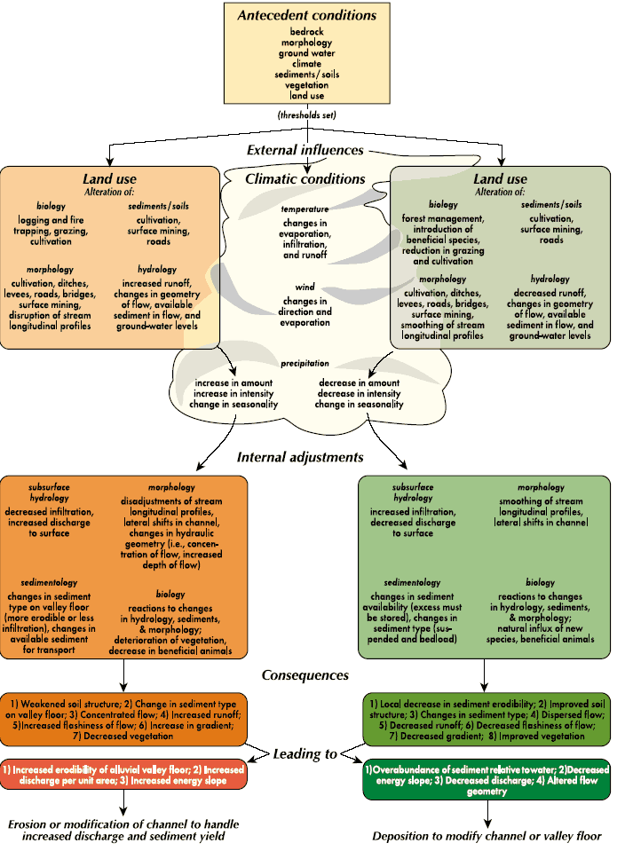
As a result of considering all these factors, one may construct a generalized pathway diagram (Fig 1) to show how adjusting different variables may result in forming the same type of arroyo channel. For example, if land use changes rainfall runoff and vegetation, increased water flow may increase sediment transport, causing erosion of the channel base and resulting in a deep, narrow channel or arroyo. A similar diagram could be used to show how arroyos could be filled in.
One drainage basin near Santa Fe, the Frijoles Basin, has been the subject of scientific scrutiny off and on for nearly 50 years to see how arroyos behave through time. The initial study applied simple monitoring techniques that have withstood the test of time. The locations of the monitors were marked with steel rebar and big nails with washers driven into the ground. Where the soil eroded, the washers followed the ground surface down. Where the ground surface aggraded, the nails and washers were buried. In the channels, 4-ft-deep (1.22 m) post-like holes were dug and loose chains were lowered into the holes to the level of the sediment surface. When streams scoured, the chains fell over to the level of scour and oriented their links downstream. Where streams aggraded, the chains were buried. The size and shape of the channels were measured in the 1950s and 1960s and have been remeasured since then more than once. In general the channels have eroded a little bit [entrenched approximately 1.2 inches (about 3 cm) on average] and gotten about 4% bigger in width and depth. The biggest changes were noted where new roads had disrupted the channels—causing deposition upstream from culverts and erosion as much as 5 ft (1.53 m) below culverts.
The banks of arroyos commonly preserve evidence to show that drainages have a history of aggrading and eroding. In the Santa Fe area, it is common to find artifacts of various ages within the sediments cut by arroyos. Some low stream banks along arroyos such as Tesuque Arroyo have developed during the 20th century and have metal cans and glass in them. Older banks contain prehistoric potsherds and fire hearths used by early Native Americans. Some stream banks show that prehistoric arroyos were eroded and later filled in before the extensive human land use changes associated with arroyo erosion of the late 19th and early 20th centuries. Some drainages have multiple episodes of arroyo cutting and filling; others have none. Clearly some drainages are more responsive to changes in climate, vegetation, and land use than others.
What Can Property Owners Do?
Management of the natural or human-influenced landscape depends on the many variables involved in shaping that landscape. The location of the land within the drainage basin, the slope of the land, the microclimate and vegetation, soils, and bedrock all play a role in determining what the “best” management practice may be. The projected future use of the land also may determine what the best current management should be. In this semiarid climate with intense summer rains, property owners may want to keep as much precipitation and vegetation on the land as possible and to slow the erosion and movement of sediments off the land. Disturbances such as roads and overgrazing lead to more runoff and more erosion. Commonly it is prudent not to alter the gradient of slopes and stream channels with soil removal or berms. Check dams may temporarily trap sediment and decrease erosion, but after the small dams fill, the problem may be worsened by entrenchment of the dams and sediments behind the dams.
What Can Geologists, Engineers, and Soil Scientists Do?
Hydrologic engineers are developing increasingly sophisticated modeling techniques to predict runoff, stream flow, and sediment transport within drainage basins. The modelers require detailed quantitative knowledge of the landscape variables of topography, rocks, soils, vegetation, and climatic variability outlined above. Geologists, soil scientists, hydrologists, and biologists all can contribute by documenting the details of the landscape variables and gathering them into geographic information systems (GIS). Geologists and soil scientists may also help by testing the results of the models by monitoring landscape changes in relation to weather-related events, longer-term climate fluctuations, vegetation changes, land-use changes, etc. Finally, geologists and paleobiologists can determine the longer-term record of changes by studying the sediments stored in arroyo banks and other deposits. New, more sophisticated techniques may be developed to extract the flood, vegetative, and climatic record from these deposits. More publicity about the complicated behavior of stream channels and banks may alter the present perception that all arroyos are caused by overgrazing or mining of streambeds. Greater public awareness of stream behavior may make both property sellers and buyers more apt to consider the consequences of property use in potentially erosive or flood-prone areas.
What Can Decision Makers Do?
Be aware of the complexity of drainage basins and their response to change. One can never do just one thing—there are always consequences both upstream and downstream. Once the work of a drainage basin is disrupted, humans will have to take on a workload to make up for what the stream used to do naturally. The dilemma for decision makers is how to balance the protection of would-be buyers and users of property at risk from arroyo erosion versus the undue burden of expensive engineering measures to curb runoff and erosion, regardless of the property's location. Impacts of erosion or sedimentation upstream or downstream from particular property are difficult to assess, but may lead to legal complications. Some municipalities and counties have zoning restrictions that may aid in limiting inappropriate uses of some property. All construction of public facilities should have proper evaluation before bidding takes place and should have supervision of the site during the building phase.
Where Can I Get More Information?
- http://climchange.cr.usgs.gov/rio_puerco/
- Cooke, R. U., and Reeves, R. W., 1976, Arroyos and environmental change in the American Southwest: Oxford University Press, 213 p. Gellis, A., Emmett, W., and Leopold, L., in review, Arroyo de los Frijoles revisited after 30 years of geomorphic change in a semiarid watershed: U.S. Geological Survey.
- Graf, W. L., 1983, The arroyo problem: paleohydrology and paleohydraulics in the short term; in Gregory, K. G. (ed.), Background to paleohydrology: New York, John Wiley, p. 279–302.
- Leopold, L. B., Emmett, W. E., and Myrick, R. M., 1966, Channel and hillslope processes in a semiarid area, New Mexico: U.S. Geological Survey, Professional Paper, 352-G, p. 193–253.
- Love, D. W., 1997, Historic incision of the middle Rio Puerco of the East—implications for models of arroyo entrenchment and distribution of archaeological sites; in Duran, M. S., and Kirkpatrick, D. T. (eds.), Layers of time, papers in honor of Robert H. Weber: Archaeological Society of New Mexico, v. 23, p. 69–84.
- Schumm, S. A., and Hadley, R. F., 1957, Arroyos and the semi-arid cycle of erosion: American Journal of Science, v. 255, p. 161–174.
- Meyer, D. F., 1989, The significance of sediment transport in arroyo development: U.S. Geological Survey, Water Supply Paper 2349, 61 p. Tuan, Yi-Fu, 1966, New Mexican gullies—a critical review and some recent observations: Association of American Geographers, Annals, v. 56, p. 573–97.
- Wells, S. G., Love, D. W., and Gardner, T. W., 1983, Chaco Canyon country: American Geomorphological Field Group, Field Trip Guidebook, 253 p. (several articles concerning arroyo behavior in northwestern New Mexico).
- Warren, A. H., 1984, Arroyos and archaeology in New Mexico: COAS, New Mexico, Archaeology and History, v. 2, no. 2, p. 20–43.
This document was reproduced from the 2001 Decision-Makers Field Guide—Water, Watersheds, and Land Use in New Mexico.