


National Uranium Resource Evaluation Data (NURE)
We are a research and service division of:
Database Manager: Dr. Virginia
McLemore
Data Interpretation:
Dr.
Richard Chamberlin
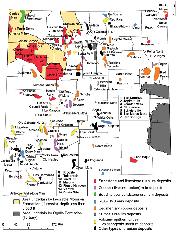
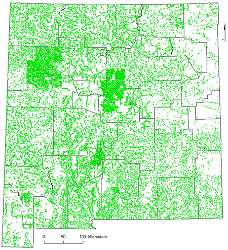
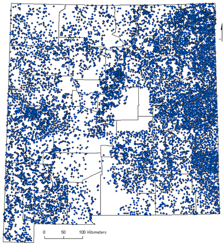
A regional geochemical (stream sediments and ground waters) and geophysical (magnetic and radiometric) database exists for the state of New Mexico. These data were generated from reconnaissance surveys as part of the U.S. Department of Energy’s National Uranium Resource Evaluation (NURE) program (1974-1984) and are available as maps and open-file reports through the Bureau. Integration of NURE data with available geologic maps and other geologic reports can provide a better understanding of the geology and geochemistry of New Mexico. The main purposes of the NURE program were to provide an assessment of the nation's uranium resources and to identify areas favorable for uranium mineralization. Elements of the NURE program include: geochemical surveys and maps, geologic maps, geophysical surveys, quadrangle assessments for uranium resources, miscellaneous geologic investigations, and drilling projects. The NURE database also includes numerous reports describing uranium resources in New Mexico. A free pamphlet describing the acquisition of NURE data is available for download (McLemore and Chamberlin, 1986).
The NURE data is typically arranged by 1x2 degree quadrangles, although a few areas were sampled and evaluated in greater detail. Two types of geochemical data exist, stream sediment and water data. Chemical analyses for New Mexico were performed at two national laboratories (Los Alamos and Oak Ridge) and each laboratory utilized different analytical techniques and elements. The stream sediment data, water data and analytical methods for the NURE program are available as U.S. Geological Survey Open-file Report 97-492 (Smith, 1997). The aeromagnetic and aeroadiometric data are available as U.S. Geological Survey Open-file Report 2009-1129 (Hill et al., 2009).
The NURE data were not designed to reveal uranium or other mineral deposits, but if used with caution, can identify areas of potential geochemical interest for further study. Numerous studies have utilized the NURE data for New Mexico to evaluate mineral resource potential (Laughlin et al., 1985; Bartsch-Winkler and Donatich, 1995; Bartsch-Winkler, 1997; New Mexico Bureau of Mines and Mineral Resources et al., 1998; McLemore et al., 2001), regional geochemical mapping (Zumlot et al., 2009), identify areas of geochemical anomalies (Chamberlin, 2009), provide insight into sedimentological processes (Chamberlin et al., 1992), and environmental studies.
In addition to the NURE data, the Uranium Library contains published and unpublished reports on the uranium deposits in New Mexico. Numerous unpublished mine maps and reports from uranium companies and the Atomic Energy Commission (AEC) are included in the collection. Additional data are always welcome.
A more detailed pamphet describing the NURE data available from the Bureau of Geology is available for free download in PDF format.
REFERENCES
- Bartsch-Winkler, S.B. and Donatich, A.J., ed., 1995, Mineral and Energy Resources of the Roswell Resource Area, East-Central New Mexico: U.S. Geological Survey, Bulletin 2063, 145 p.
- Bartsch-Winkler, S.B., ed., 1997, Geology, mineral and energy resources, Mimbres Resource Area, New Mexico: U.S. Geological Survey, Open-file Report 97-521, CD-ROM
- Chamberlin, R.M., Harris, J.S., and Onimole, M.I., 1992, A stream-sediment geochemical map (from NURE data) showing the bulk silica distribution within the Eocene San Jose Formation, San Juan Basin, New Mexico: New Mexico Geological Society Guidebook 43, p. 317-320.
- Chamberlin, R.M, 2009, Rare-earth geochemical anomaly at Sierra Larga, New Mexico: NURE stream sediment data suggest a monazite placer deposit in the Permian Gloria Sandstone: New Mexico Geological Society Guidebook 60, p. 71-73
- Hill, P.L., Kucks, R.P., and Ravat, D., 2009, Aeromagnetic and aeroradiometric data for the conterminous United States and Alaska from the National Uranium Resources Evaluation (NURE) Program of the U.S. Department of Energy: U.S. Geological Survey Open-File Report 2009–1129, http://pubs.usgs.gov/of/2009/1129/
- Laughlin, A.W., Cole, G.L., Freeman, S.H., Aldrich, M.J., and Maassen, L.W., 1985, A computer assisted mineral resource assessment of Socorro and Catron Counties, New Mexico: Geology and Geochemistry Group, Earth and Space Sciences Division, Los Alamos National Laboratory, Los Alamos, New Mexico, unclassified report LA-UR-85-375.
- McLemore, V. T., Donahue, K., Breese, M., Jackson, M. L., Arbuckle, J., and, Jones, G., 2001, Mineral-resource assessment of Luna County, New Mexico: New Mexico Bureau of Mines and Mineral Resources, Open file Report 459, 153 pp., CD-ROM, https://geoinfo.nmt.edu/publications/openfile/downloads/OFR400-499/451-475/471/ofr_471.pdf
- McLemore, V.T. and Chamberlin, R.M., 1986, National Uranium Resource Evaluation (NURE) data available through New Mexico Bureau of Mines and Mineral Resources: New Mexico Bureau of Mines and Mineral Resources, pamphlet, 11 p.
- New Mexico Bureau of Mines and Mineral Resources, New Mexico State University Southwest Technology Institute, and TRC Mariah Associates, Inc., 1998, Mineral and energy resource assessment of the McGregor Range (Fort Bliss), Otero County, New Mexico: New Mexico Bureau of Mines and Mineral Resources Open-file report 456, 543 pp., https://geoinfo.nmt.edu/publications/openfile/downloads/OFR400-499/451-475/456/ofr-456.pdf
- Smith, S.M., 1997, National geochemical database: reformatted data from the National Uranium Resource Evaluation (NURE) Hydrogeochemical and Stream Sediment Reconnaissance (HSSR) Program, version 1.4 (2006): U.S. Geological Survey Open-file Report 97-492. http://pubs.usgs.gov/of/1997/ofr-97-0492/
- Zumlot, T., Goodell, P., and Howari, F., 2009, Geochemical mapping of New Mexico, USA, using stream sediment data: Environmental Geology, v. 58, p. 1479-1497.
Updated June 14, 2022