


GM-64—Geology and coal resources of Vanderwagen quadrangle, McKinley County, New Mexico
We are a research and service division of:
By O. J. Anderson, 1990, lat 35°15' to 35°22'30", long 108°45' to 108°52'30", 1 sheet with text, scale 1:24,000.
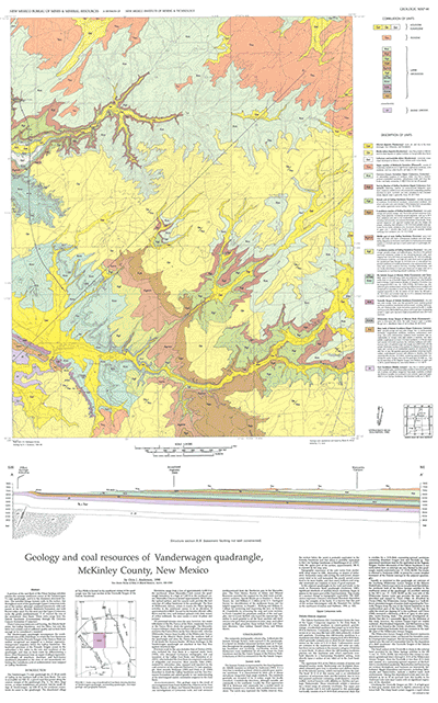
Vanderwagen 7½-min quadrangle is in the southern part of the Zuni Basin in southwest McKinley County approximately 15 mi south of Gallup. Elevations range from lows of approximately 6,650 ft in the Manuelito Canyon in the northwest part of the quadrangle and of approximately 6,800 ft where Whitewater Arroyo crosses the Piñon Springs anticline in the southwest corner of the quadrangle (type locality of the Whitewater Arroyo Tongue of the Mancos Shale) to a high of 7,283 ft in the northeast corner. Middle Jurassic (Zuni Sandstone) through Tertiary (Bidahochi Formation) units exposed in the quadrangle dip gently 1°– 4º to the northeast toward the center of the Zuni Basin. Most of the outcrops, however, are Upper Cretaceous rocks of the Dakota-Mancos sequence and the coal-bearing Gallup Sandstone and Crevasse Canyon Formation. Quaternary eolian sand and alluvial deposits of sand, silt, and clay blanket much of the older strata. GM-64 includes detailed discussions of the coal resources, regional stratigraphy, and regional relationship between the Gallup Sandstone and the Tres Hermanos Formation, one cross section, and 15 map-unit descriptions. This is a companion to GMs 65 and 66.
$6.00
Buy
Now
Also available as a free download.
Download
| File Name | Size | Last Modified |
|---|---|---|
| GM-64.pdf | 11.58 MB | 02/05/2021 04:01:45 PM |
| TIFF: | ||
| GM-64_map.tif | 7.10 MB | 07/30/2019 10:20:32 AM |