


GM-68—Geology of Lion Mountain and northern Arrowhead Well quadrangles, Socorro County, New Mexico
We are a research and service division of:
By G. R. Osburn, T. M. Laroche, and R. H. Weber, 1993, lat 34°05' to 34°15', long 107°30' to 107°37'30", 11 pp., 1 sheet, scale 1:24,000.
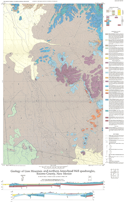
The area covered on this map lies north of NM-60, almost midway between Magdalena and Datil. Physiographically, it occupies the slope between the Gallinas Mountains to the east and the White Lake section of the Plains of San Augustin to the west. All rocks exposed within the map area are Tertiary volcanic or volcaniclastic rocks. Most of the volcanic rocks are regional ash-flow tuffs and lava flows from local vent areas. Eolian sand from the Pleistocene lake beds mantles extensive lacustrine, basin, and piedmont-slope deposits. Twenty lithologic units are mapped and described on the sheet, and relict shorelines of Lake San Augustin, identified in the southwest half of the area, are plotted in blue. Two cross sections illustrate regional structure. An 11-pp. text describes in detail each map unit, structural features in and around the study area, evidence of mineralization, and unusual wind-scoured rocks near the summit of Lion Mountain.
$5.00
Buy
Now
Also available as a free download.
Download
| File Name | Size | Last Modified |
|---|---|---|
| GM-68_booklet.pdf | 11.95 MB | 02/05/2021 04:02:59 PM |
| GM-68_complete.zip | 15.07 MB | 02/05/2021 04:03:17 PM |
| GM-68_map.pdf | 4.15 MB | 02/05/2021 04:03:05 PM |
| TIFF: | ||
| GM-68_map.tif | 72.05 MB | 09/07/2018 09:08:07 AM |
| GM-68_map_pal.tif | 12.67 MB | 09/07/2018 09:09:54 AM |